Showing 1372 results

Archival description
267 results with digital objects Show results with digital objects
Stewart River townsite
2012.13.2.15.27 · File · 2001
Part of J. Kent Sedgwick fonds

File consists of notes and reproductions relating to the Stewart River townsite. Includes photographs depicting newspaper articles about the Stuart River.

2012.13.2.02.33.10 · Item · [1990?]
Part of J. Kent Sedgwick fonds

The item is a reproduction of a survey map drafted June 1912. The reproduction was likely created in 1990. The area covered is Central Fort George, South of 5th Street, East of Alden Avenue, North of 12th Street and West of Fraser Street. Annotations state, "Plan 1085 Carney Addition."

2012.13.2.02.33.06 · Item · [1990?]
Part of J. Kent Sedgwick fonds

The item is a reproduction of a survey map drafted in approximately 1911 and revised in May 1914. The reproduction was likely created in 1990. The annotation states, "Plan 1391" and is circled in red ink. The area covered is along the Nechako and Fraser Rivers and Northeast of First Avenue.

2012.13.2.02.33.01 · Item · [1990?]
Part of J. Kent Sedgwick fonds

The item is a reproduction of a section of survey map drafted on 18 March 1915 and revised on 23 May 1916. The reproduction was likely created in 1990. The Plan Number is 1268 and highlights the area along the Nechako and Fraser Rivers. The map details subdivisions East of Carney Street, North of Twentieth Avenue and South of Ninth Avenue. Annotations in pencil state different map scale variations and "cemetery setback."

Subdivision planning
1996.8.4.29 · File · [between 1970 and 1990]
Part of Chander Suri fonds

File consists of neighbourhood planning maps for Langley, Abbotsford, Prince George, and Aldergrove. Includes housing plans in Calgary and a newspaper clipping.

Sutherland Land Company
2012.13.2.20.14 · File · 2011
Part of J. Kent Sedgwick fonds

File consists of notes and reproductions relating to the Sutherland Land Company created by the 4th Duke of Sutherland.

2020.4.4.07 · File · 1993
Part of G. Gary Runka fonds

File consists of records relating to the Agricultural Land Commission symposium "Urban Development and the ALRD: 'Up Not Out'" on March 9, 1993. Gary Runka attended as a speaker with the address "Agriculture in the Urban Shadow". Includes correspondence, symposium material, agenda, a copy of Ray Spaxman's speech "Urban Form in a Sustainable Region", attendee folder, notes, and background material. Also includes Agricultural Land Commission 'Preserving our Foodlands' buttons.

2006.20.3.26 · Item · [between 23 May 1906 and 15 October 1906]
Part of Northern BC Archives Historical Photograph Collection

Photograph depicts two unidentified men standing to right of flag mounted in rock pile.

Image is one of 65 photos documenting a survey of the Canada-Alaska Boundary, Taku River area, May 23 to Oct. 15, 1906.
This particular photo is one of 13 found in original enclosure with the following handwritten annotation: "SOME OTHERS." See also items 2006.20.3.22 - 2006.20.3.34.

2006.20.3.55 · Item · [between 23 May 1906 and 15 October 1906]
Part of Northern BC Archives Historical Photograph Collection

Photograph depicts two unidentified men standing to right of flag mounted in rock pile.

Image is one of 65 photos documenting a survey of the Canada-Alaska Boundary, Taku River area, May 23 to Oct. 15, 1906. This particular photo is one of 10 found in original enclosure with the following handwritten annotation: "From [Wahut?]-Azmuth and Koshu.” See also items 2006.20.3.47 - 2006.20.3.56.

2006.20.3.61 · Item · [between 23 May 1906 and 15 October 1906]
Part of Northern BC Archives Historical Photograph Collection

Photograph depicts two men on either side of camera on tripod, flag visible behind them. Mountain range and glacier in background.

Image is one of 65 photos documenting a survey of the Canada-Alaska Boundary, Taku River area, May 23 to Oct. 15, 1906. This particular photo is one of 9 found in original enclosure with the following handwritten annotation: "Pictures of different members of ‘our’ party.” See also items 2006.20.3.57 - 2006.20.3.65.

2020.4.6.360.02 · Item · 10 Dec. 1993
Part of G. Gary Runka fonds

Audio cassette titled "Tape 2 - Dec. 10, 1993 - 1:45-5:00" is believed to be an audio recording of a workshop for the East Kootenay CORE project.

2020.4.6.360.03 · Item · 10 Dec. 1993
Part of G. Gary Runka fonds

Audio cassette titled "Tape 3 - Dec. 10, 1993 - 5:00-" is believed to be an audio recording of a workshop for the East Kootenay CORE project.

Tape 5: 2:45-4:05
2020.4.6.425.1 · Item · 1996
Part of G. Gary Runka fonds

Audio cassette titled "Tape 5: 2:45-4:05" is believed to contain a recording of a workshop related to the Vernon commonage project.

Tape 6: 4:05-5:10
2020.4.6.425.2 · Item · 1996
Part of G. Gary Runka fonds

Audio cassette titled "Tape 6: 4:05-5:10" is believed to contain a recording of a workshop related to the Vernon commonage project.

Tape 7: 5:10-5:50
2020.4.6.425.3 · Item · 1996
Part of G. Gary Runka fonds

Audio cassette titled "Tape 7: 5:10-5:50" is believed to contain a recording of a workshop related to the Vernon commonage project.

2020.4.9.2.16 · File · 2008
Part of G. Gary Runka fonds

This CD-ROM contains digital records collected by Gary Runka during his consultancy work for client job 650, Canoe Creek Indian Band's "Overview of Issues and Concerns Related to Transmission Line Corridor Component" project. Includes three PDF format maps prepared by AXYS Ltd. for Taseko Mines Ltd. Prosperity Project depicting "Taseko Transmission Corridor Orthophotography".

2009.6.1.543 · Item · 1999
Part of The Honourable Iona Campagnolo fonds

The group stands in front of an ornate stone wall and two Canadian flags.

Handwritten annotation on photograph enclosure reads: “8/6/99. Dear Lady, When I saw this photograph I knew there was a certain person who would truly appreciate and ‘feel’ its significance. Not many steps left to take now . . . . your unwavering support is never more appreciated. best personal regards, Peter”; handwritten annotation on verso reads: “Nisga’a”.

Tete Jaune Cache and Penny
2012.13.2.17.37 · File · 2004
Part of J. Kent Sedgwick fonds

File consists of handwritten notes by Kent Sedgwick relating to pack saddling to Tete Jaune Cache in 1962. Also includes a photograph depicting Cecil Giscombe in Penny (May 2004).

2020.4.4.18 · Item · 1979
Part of G. Gary Runka fonds

Item is an original copy of a 1979 promotional booklet produced by the BC Agricultural Land Commission entitled "The Agricultural Land Reserve: Protecting B.C.'s Farmland". The booklet was prepared for the Provincial Agricultural Land Commission by J.M. Sawicki. Photographs by G.G. Runka.

2020.4.2.1.35 · File · Sept. 1979
Part of G. Gary Runka fonds

File consists of a speech given by Gary Runka entitled "The BC Agricultural Land Preservation Experience" to the Canadian Agricultural Extension Council Conference in Kelowna.

Commentary on this speech by Barry Smith of the Ministry of Agriculture and Lands:
"This speech represents a major paper that reiterates historical themes concerning the legislative initiative, B.C's very limited area available for agricultural production and the designation of the ALR plans.

GGR emphasizes that the main criteria when considering applications under the ALC Act is the soil/climate capability for agriculture. He mentions that the actual designation of the ALR and its subsequent refinement was fairly straight-forward but: "Much more difficult is the task that we are now facing, to make the right land-use decisions within the agricultural zone and encourage good land-use planning adjacent to it in order to accomplish the stated objectives."

GGR remarks that the ALC Act is based on the assumption that there are alternatives to farmland for urban uses and he personally agrees that alternatives do exist in almost all cases but he cautions: "But, the ability and willingness to go in these other directions necessitates a radical change in thinking on the part of governments, private industry, real estate interests, and the general public. It also demands an acceptance of the fact that agricultural land preservation is in British Columbia to stay and it assumes a commitment to preserve the agricultural industry as being in our own long term best interests. Some vibrations tell me we still have not quite made the grade in this area." These words were spoken by the Chair of the ALC 36 years ago and could be as appropriately be spoken by any of the subsequent ALC's Chairs to this day.

Competing land uses are listed and guidelines on expected policy content in Official Settlement Plans developed under the Municipal Act aimed at the protection of agricultural land and agriculture are noted.

Three examples are provided of studies to explore alternate areas of growth along with work on dealing with impact issues (edge/interface planning). GGR emphasizes the challenge of dealing with other governmental agencies and ends by outlining 3 general approaches to look at land needs, land uses and resource planning:

  1. Make land use decision based on the inherent natural characteristics rather than protecting land values or simply accommodating growth;
  2. The Fall 1977 amendments to the Act allowing greater Cabinet involvement will test the program but also emphasizes the importance of shared decision making; and
  3. The ALC Act has defined a land use priority and a direction around which all others can plan and there is a need for a national land use policy that GGR supports."
"The Bog Forests"
2020.4.2.3.051 · Item · 1980
Part of G. Gary Runka fonds

Item is a 1980 paper entitled "The Bog Forests" by the Corporation of the Township of Richmond Environmental Control Officer and Planning Department.

2020.4.2.1.23 · File · 1977-1978
Part of G. Gary Runka fonds

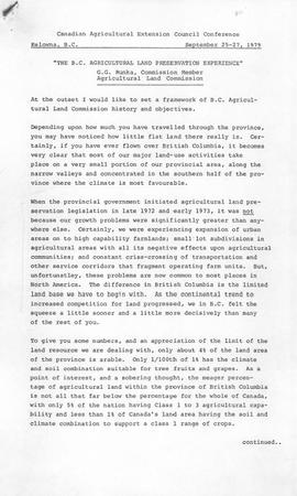
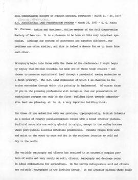
File consists of a speech given by Gary Runka entitled "B.C. Agricultural Land Preservation Program". This speech was originally given on March 23, 1977 at the Sol Conservation Society of America National Symposium. Includes a version of the speech turned into a paper submitted for publication as "British Columbia's Agricultural Land Preservation Program" in the Assessors Journal. The speech and paper is accompanied by:

  • supplementary transparencies for presentation
  • Resume for G. Gary Runka
  • Canada Land Inventory Ratings
  • Summary of Applications Processed under the Land Commission Act
  • Areas Included and Excluded from the ALR by Year
  • Flow Chart for Applications under the Agricultural Land Commission Act

Commentary on this speech by Barry Smith of the Ministry of Agriculture and Lands:
"This speech was given on March 23, 1977 and represents a major paper given to an international audience.

GGR provides a contextual overview of B.C. and breaks his speech into an overview of the legislation, how the ALR was established and the administration of the Reserve.

The speech, in part, draws upon themes in other speeches but this paper tends to pull all these subjects together in this single presentation.

GGR notes that up to this point 80% of the exclusion applications are from non-farmers and it is estimated that the program has saved 40,000 acres (16,187 ha.) of farmland from being converted to irreversible uses.

GGR outlines several key principles to having a successful program to preserve agricultural land including:

  • Regulations must be based on solid technical data people can understand;
  • Any control mechanism needs to be basically apolitical;
  • Must include shared decision-making - local governments and the public were involved in creating the ALR plans and local governments continue to provide comments and recommendations on applications; and
  • Ensure opportunity for integration and communication with the Ministry of Agriculture and other provincial government agencies and Advisory Committees of the B.C. Federation of Agriculture.

This speech was published as part of the symposium proceedings: "Land Use, Tough Choices in Today's World: The Proceedings of a
National Symposium, March 21-24,1977, in Omaha, Nebraska" by the Soil Conservation Society of America."