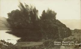
Photograph of a large explosion on a rocky shoreline. A bridge is visible in the foreground and a body of water is partially visible in the background. Printed annotation on recto reads: "McRae Bros Moving Mountains at Prince Rupert BC Apr 24th" Handwritten annotation on verso reads: "Rupert. July 17 1913. Dear [illegible]. Just a card for that album if you've got any room left by now. This is one of the blasts for the clearing of the drydock up here. [Illegible] W.M." Postcard is addressed to: "Miss C.M. Ranip[??] 931 Northlane Av.[sic] Seattle Wash." Two Canadian one cent stamps are affixed on verso. Postmark reads: "Prince Rupert BC. PM Jul 17 13."
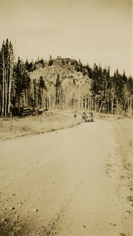
Photograph depicts Mount Begbie, noted by Wyness to be the highest point on the Cariboo Highway at mile 85. Mount Begbie is located at approximately 51°28'33''N, 121°22'00''W, on the east side of Cariboo Hwy, between 70 Mile House and 100 Mile House, in the Lillooet Land District. Wyness annotated this photograph with the statement that they "tied this one in"; 'tying in' is a land survey term, implying that the crew may have also been surveying in this area.
File consists of notes and reproductions relating to Mud River Elementary School. Also includes photographs depicting old Mud River buildings and roads.
Item is an original booklet by BC Cattlemen's Association entitled "Munching the Myths: a Factual Account of the Beef Cattle Industry in British Columbia".
File consists of zoning and property information including Regional District of Fraser Fort-George public hearing notifications, Quesnel subdivision and zoning bylaws, subdivision application guide, land use assessments, and multiple topographic and lot maps for Prince George, Burns Lake, Quesnel, and Fraser Lake.
File consists of an oral history given by Murray Krause, which was gathered as part of Dr. Mike Evan's Island Cache Recovery Project. Includes consent forms, transcripts, and the recorded oral history on the original media.
File consists of Carrier Sekani Tribal Council correspondence, briefs, plans, register population data, cost estimates, maps, planning background report, and physical development plan.
File consists of a physical development plan for the Nadleh Whut'en Band prepared by the Carrier Sekani Tribal Council.
File consists of a draft of the Nak'azdli Band physical development plan and a copy of the final version.
File consists of clippings, notes, and reproductions relating to the naming of the city of Prince George and the origins of the name. Includes: "Proclamation" photocopy of British Columbia Gazette discussing the naming of the city of Prince George (1915); "Prince George needs a new name" print of pgcitizen.ca article by Neil Godbout including comments on the article (July 2009); "Prince George" in Prince George Citizen, Northern Explorer (May 2006); and "History of Prince George" in a Prince George Towncenter Business Association publication (July 1985).
File consists of a brochure for Nelson Homes, a home construction company with a range of predesigned homes to choose from, with a business card of Prince George based home specialist R.J. (Bob) Fines stapled to the brochure.
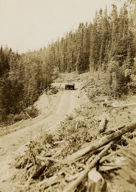
Photograph depicts a work vehicle on new road during road making north of Stuart Lake.
File consists of photocopied newspaper articles about Island Cache (Cottonwood Island) and the relocation of its residents.
Item is an original copy of "Non-Farmland with Long Term Urban Potential in the Lower Mainland" by the BC Agricultural Land Commission.
Item is an original copy of "Non-Farmland with Long Term Urban Potential in the South Okanagan" by the BC Agricultural Land Commission.
Item is a copy of the "North American Water and Power Alliance (NAWAPA)" presentation to Cornell University Water Resources Center, Ithaca, New York by Roland P. Kelly, Edward R. Trapnell, and Ralph M. Parsons Company.
File consists of documents pertaining to the sale of North Meadows Subdivision lot no. 10, prepared by Heights Land Development Co.
Item is a hand drawn and coloured map by the City of Prince George Planning Department depicting North Nechako neighbourhood area existing land use in 1976.
Item is a hand drawn and coloured map by the City of Prince George Planning Department depicting the North Nechako and Hart neighbourhood area proposed land use in 1976.
File consists census data from the North West and Peace River regions between 1966 and 1968. Also includes population data from 1951, 1956, 1961, and 1966.
File consists of photocopied lot maps for multiple locations including Porcher, Naikoon Park, Prince Rupert, Cranbrook, Nelson, and Comox.
Photographs within this file document stern wheelers operating in Northern BC from ca. 1901 - 1915.
File consists of a guide to Northern BC parks and attractions.
File consists of correspondence between the Northern Planners and the Planning Institute of BC (PIBC) regarding the formation of the northern group. Includes correspondence between the Northern Planners and PIBC as well as meeting minutes from the Northern Planners.
Item is a photocopied draft of the Northern Wetlands Research Project Final Report by P. Lynch-Stewart, B. Heli & D. Ouimet for Lands Directorate, Environment Canada.
File consists of notes written by Joan Sawicki for an untitled pending speech by Gary Runka.
Commentary on this speech by Barry Smith of the Ministry of Agriculture and Lands:
"Despite this being only 4 pages of rough notes, its focus on the initial work of the Commission and challenges of designating the ALR make it an historically important document.
For example it was initially thought the ALR would be guided by class 1 - 4 CLI ratings but this proved impractical in the north and range areas. An additional challenge was that parts of the province only had the benefit of 1:50000 mapping. This presented a very real problem for establishing the ALR.
One concern with this document is that because it is written in point form and consists of rough notes, it could be open to a degree of misinterpretation if not considered by an individual with experience in the administration of the ALR. For a much more refined statement on the B.C. Agricultural Land Preservation program and the designation of the ALR see Items [2020.4.2.1.23, 2020.4.2.1.24, and 2020.4.2.1.25]."
File consists of an offering memorandum on the 48 suite strata-title Westwood Apartments.
File consists of correspondence between Chander Suri and Kent Sedgwick regarding the development of the Official Community Plan bylaw no. 5909 for Prince George. Includes newspaper clippings, bylaw no. 3848, and a schedule for public hearings.
File consists of documents concerning the drafting of the City of Prince George's Official Community Plan between 1997 and 2006. Includes correspondence between planners, handwritten notes, questionnaires, staff reports, cost charge fee schedules and reviews, and a Department of Development Services bylaw update.
This CD-ROM contains digital records compiled for Gary Runka in relation to the OCP for Rural Graham Island, possibly for his consultancy work for client job 664, Misty Isles Economic Development Society's "Food Planning Presentations on Haida Gwaii" project or another Haida Gwaii based project. Includes correspondence, Canada Land Inventory maps for Haida Gwaii, the draft 2009 Official Community Plan for Rural Graham Island, Graham Island zoning documents, and population information for Graham Island and Tlell.
File consists of an official regional park plan for the Regional District of Fraser-Fort George.
File consists of an official regional plan for the municipalities of Prince George and Mackenzie, prepared by the Planning Department of the Regional District of Fraser-Fort George. Includes an accompanying map for the Official Regional Plan.
Item is a newsletter entitled "Old Growth: What is at stake?".
File consists of a clipping, printed emails, and reproductions relating to the Omineca region and Sedgwick's research. Includes: "Have you been to Hyder, friendliest ghost town in Alaska" large sticker (199-); and "Historical Museum Stewart B.C". large sticker (199-).
Item is an original copy of "On Nature's Terms" by the Fur Institute of Canada.
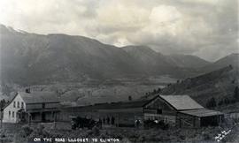
Photograph depicts a ranch home and barn along the road from Lillooet to Clinton. The location is believed to be a homestead 2 miles south of Pavilion Station. Two cars are parked beside the property, with a number of men nearby.
File consists of a report from Northern Interior Health regarding sewage disposal. Includes a press release and lagoon survey.
Series consists of digital records on optical disc media (CDs and DVDs) created or collected by Gary Runka and Joan Sawicki for personal and professional purposes. Includes computer back-ups, film documentaries, and digital publications on disc.
Series consists of the 46 oral histories conducted by the Island Cache Recovery Project. A file exists for each participant in the research project, which includes the original recorded oral history on cassette tape and/or VHS, consent forms for use of the oral history, a written transcript for the oral history, and a digital version of the written transcript. Label on diskette states, "Island Cache Research Project. Transcription of Heinz Bartkowski interview (by: Lori Koop) June 12-99 file: Heinz.rtf FNST 272."
File consists of material relating to placenames in British Columbia, specifically places in the Central Interior. Materials include newspaper clippings and correspondence.
Item is an original BC Wild booklet entitled "Overcutting the Chilcotin: Putting at Risk Southern BC's Great Caribou Herd".
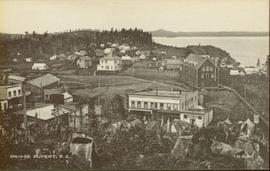
Wide angle photograph of many buildings scattered in a clear cut area. Foreground shows several businesses, including "Kelly Carruther's Supply" and "Prince Rupert Hardware and Supply Co." Some remaining forest is visible in the background. Annotation on recto reads: "Prince Rupert, BC 1659."
File consists of a speech given by Gary Runka entitled "Overview: Planning for Rural Land" for the Canadian Institute of Planners Annual Conference in Kitchener, Waterloo. Includes newspaper clipping titled "A pathetic tale of two resources" from the Victoria Colonist, June 22,1980.
Commentary on this speech by Barry Smith of the Ministry of Agriculture and Lands:
"This speech is aimed at the "urban" planner who is planning in rural areas. While 'rural land' can encompass many things and there are only passing references to agriculture, the planning approaches and principles - like the need for the urban planner to view the world from the rural side of the fence - is often going to involve agricultural land.
Mention is made of integrated natural resource management and an emphasis is made on the planner understanding the rural perspective.
The comment (warning) is made that "...the rural land use tug-of-war between lifestyle pursuits, population demands and natural resource production will continue" - the message being that planning practitioners will probably find themselves in the midst of these tug-of-wars.
This paper clearly recognizes the challenges of introducing urban planning techniques into rural landscapes and provides some very valuable insights. While farmland preservation isn't central to this speech the rural resource and planning theme is relevant."
File consists of notes, clippings, and reproductions relating to the original Pacific Great Eastern Railway line. Also includes photographs depicting various dirt roads (2001-2010).
File consists of correspondence with multiple parties including Wright Parry Taylor & Fuller Engineering, Paldi Estates, and the Cowichan Valley Regional District. Includes notes, sewage and waste disposal assessments, state of title certificate, and applications.
File consists of a development plan for Paldi Estates, a letter about the Paldi Estates Official Community Plan Concept (OCPC), a Bamberton OCPC and town proposal, correspondence from the Cowichan Valley Regional District, highway commercial development schedule, a Stonebridge development permit area, and scans of Registration of Charge applications. Includes design guidelines for rural residential community water systems and a guide for applicants.
File consists of a water supply and sewage disposal study for the townsite of Paldi. Includes maps, correspondence, water licensing information and application, and Bayview Village advertising brochure.
File consists of typescript documents, notes, and reproductions relating to papers about the 4th Duke of Sutherland in Brooks, Alberta. File contains material regarding the 4th Duke of Sutherland conducting a settlement scheme, through the purchasing and sale of land in Brooks, Alberta. Includes: "The Contribution of the Fourth Duke of Sutherland to the Brooks Community" typescript document by the Brooks Museum (1981).
