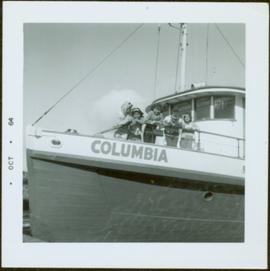
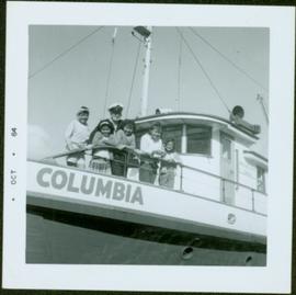
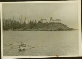
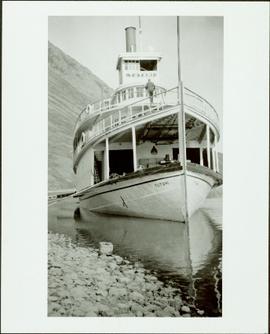
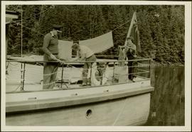
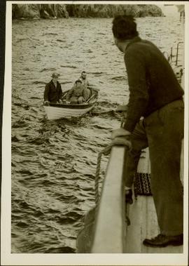
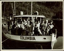
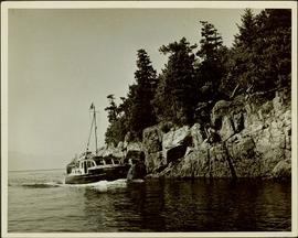
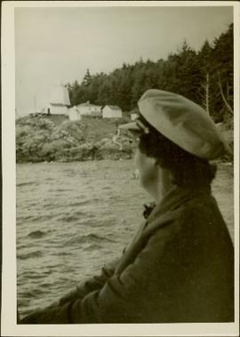
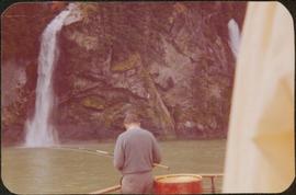
Photograph depicts a man on a boat standing with his back to the camera while holding a fishing rod. A waterfall and rocky cliff face are visible in the background. Handwritten annotation in pencil on verso reads: “Jim M.V. Columbia 1959”
Photograph depicts five First Nations children leaning over the deck on the M.S. Columbia. Stamped annotation on recto: “Oct – 64”. Handwritten annotation in pen on verso reads: “Mamalicula”
Photograph depicts five First Nations children and a ship captain on the deck of the M.S. Columbia. Stamped annotation on recto states: “Oct – 64”
Photograph depicts a woman wearing a Cowichan sweater rowing a boat away from a rocky island with a lighthouse. Handwritten annotation in pencil on verso reads: “Gal in boat wearing Indian sweater knit by my mother Eileen M. Jackson (she also spun the wool) for her brother J.J. Claxton, cook on the Columbia Coast Mission Boat. - S.K. Jackson”
Photograph depicts the multi-level steamship "Tutshi" anchored near a rocky shoreline. Stamped annotation on verso: “Yukon Archives, Whitehorse. Print No. No. 82/378 #3; Please credit: Poirer Collection, Yukon Archives”
Photograph depicts an unidentified woman standing with a man in uniform, believed to be an officer aboard the S.S. Tutshi. Stamped annotation on verso: "Yukon Archives, Whitehorse. Print No. 82/378 #1; Please credit: Poirer Collection, Yukon Archives."
Photograph depicts a fishing camp with boats and buildings on floating docks and a forested environment visible in the background. Handwritten annotation on verso states: “1960 Seymour Inlet. Oscar Johnston’s Camp on the Move. Taken from Mission Ship Columbia”; photographer’s stamp on verso states: “W.E. Nicholson”
Photograph depicts a wharf and buildings along the shore of an unidentified fishing community with a forested environment visible in the background.
J.J. Claxton fishing aboard the M.S. Columbia while a public health nurse does laundry on deck. Handwritten annotation on verso reads: “JJ Claxton fishing”.
Photograph depicts J.J. Claxton sitting on a rocky shore with the Columbia Mission Ship in the background at dock at Bendickson. Handwritten annotation on verso reads: “Bendickson”; “JJ Claxton on rock”; photographer’s stamp on verso: “W.E. Nicholson, 268 E. 10th, Vancouver 10, B.C.”
Photograph depicts James Joseph Claxton, on board the M.S. Columbia, awaiting the arrival of a public health nurse, lighthhouse keeper and assistant lighthouse keeper who are approaching in a small boat. Handwritten annotations on verso read: “James Joseph Claxton - my uncle. Cook on the Columbia”; “James Joseph Claxton. JJC awaiting arrival of Public Health Nurse, Lighthouse Keeper and Asst Light house Keeper at Pine Island between Port Hardy & Bull Harvour. M.S. Columbia, Columbia Coast Missions (Anglican)”
Photograph depicts a group of people standing on the boat "Columbia" with a forested environment visible in the background. Handwritten annotations on verso read: “Christening at Dedricksons Camp. Drury Inlet”; “Three babies baptized this time”
Photograph depicts the boat "John Antle" motoring on the water near a rocky, tree covered cliff. Handwritten annotation on verso states: "M.S. John Antle on her rounds entering Smuggler Cove". Stamped annotation on verso reads: “The National Film Board”
Photograph depicts an unidentified woman (Public Health Nurse?) looking back over the water towards some buildings and a lighthouse on a rocky shore (Pine Island?).
Photograph depicts an unidentified man, woman, and child sitting on a docked boat. Floating house and workshop visible behind boat while a step forested slope is visible in the background. Photographer’s stamp on verso reads: “W.E. Nicholson.”
Photograph depicts an unidentified man holding the lever of a piece of wharf machinery on a dock.
Photograph depicts two unidentified men standing on a log in front of the boat "Columbia", each holding a fish in one hand and a fishing pole in the other.
Photograph depicts two unidentified Canadian Provost Corps officers driving in a jeep labelled "79 Provost." Handwritten annotation on verso reads: "No. 1 Provost Coy, England 1940". Stamped annotation on verso reads: "Negative No. 7272. Please quote when reordering."
Photograph depicts two unidentified, young First Nations girls standing hand in hand on a rocky beach. Rail tracks extending from the water to the shore are visible in the lower right corner and in the background. Handwritten annotation on verso reads: “Kingcome Reserve”
Photograph depicts the steamship Princess May run aground on the rocky shoreline of Sentinel Island. Annotation on recto of photograph states: "PRINCESS MAY - WRECKED ON SENTINEL ISLAND ALASKA - AUG. 5 1910"
Photograph depicts the forested Genn Island with the steamship Prince Rupert run aground on the rocky shore of the island. Annotation on recto of photograph states: ""Prince Rupert" Stranded On Genn Island. Nr. Prince Rupert. B.C. 23 Mar: 1917. F. Button. Photo Pr. Rupert. No 567."
Photograph depicts the steamship Prince Rupert run aground on a rocky shoreline beside a forested area. Annotation on recto of photograph states: ""Prince Rupert" Wrecked On Genn Island Nr Prince Rupert B.C. 23 March 1917. F. Button Photo Pr. Rupert No.568"
Photograph depicts a man standing in front of the steamship Prince Rupert run aground on a rocky shoreline. Annotation on recto of photograph states: "Prince Rupert" Wrecked On Genn Island Nr Prince Rupert B.C. 23 Mar' 1917. F. Button. Photo Pr Rupert No. 573" Annotation on verso of photograph states: "Dear Ted.- I am just writing you a note to remind you you have not written me since the last time. This is the way the Rupert is now she sure looks fine. I had a fine time in Rupert during the holidays. I wish you would send me some stamps. I traded Willie quite a few and two dandy, Montenegro ones. I am using my fountain pen now, it writes fine. I guess I will close your loving brother Gordon"
Photograph depicts the steamship Prince Rupert run aground on a rocky shoreline. Annotation on recto of photograph states: ""Prince Rupert" On The Rocks. Yes Sir. Snow Storm. Near Prince Rupert, B.C. 23 Mar: 1917. F. Button Photo. Pr. Rupert. No. 576"
Photograph depicts the steamship Prince Rupert run aground on a rocky shoreline with a tree in the foreground. Annotation on recto of photograph states: ""Prince Rupert" "On The Rock Dock" Nr Prince Rupert B.C. Wrecked 23 March 1917. F. Button Photo Pr. Rupert no.575."
Photograph depicts the steamship Prince Rupert after being run aground on a rocky shoreline. Annotation on recto of photograph states: "STR. PRINCE RUPERT ASHORE NEAR RUPERT MAR 23. 1917."
Photograph depicts the steamship Prince Rupert run aground on a rocky shoreline. Annotation on recto of photograph states: "S.S. Prince Rupert Wrecked March 23rd 17."
Photograph depicts yard signals of the MacMillan Bloedel & Powell River Logging Railway, primarily protecting the Comox Logging & Railway Company crossing. The Esquimalt and Nanaimo Railway is about 300 yards to the north. Crossing is near Ladysmith. It is most unusual to find signal in B.C. at this point.
Photograph depicts CPR buildings near Shawnigan Lake depot on Vancouver Island. The buildings in the centre are a section house (left) and a speeder or tool shed (right). They sit inside a wye track. Spur on the left is all that is left of "Y" turning center. The view is looking south. The Shawnigan Lake station (not depicted) is located at mile post 27.8 approximately 1/2 mile to the railway south of these buildings which are to the south of the photographer.
Photograph depicts the service car of the Esquimalt and Nanaimo Railway in front of the E & N freight shed. The Nanaimo passenger depot (not depicted) is located behind the photographer.
Photograph depicts a railway track crossover. The Comox Logging & Railway Co. tracks (left to right) cross the Esquimalt & Nanaimo tracks (bottom to top). The MacMillan Bloedel & Powell River Logging Railway tracks join the Esquimalt & Nanaimo Railway just above the crossing. The Velco Tower appears to the right of the crossing. This crossing is one mile north of Ladysmith, with the view looking north to Nanaimo.
Photograph depicts the Nanaimo passenger depot of the Esquimalt and Nanaimo Railway (at right) and the E & N freight shed (at left).
The building of this spur in 1977 was a late and short lived attempt to move yearling cattle to Ontario for fattening by rail. The Last stock train ran in 1985. The CN rail track was still in use in August 1998. This photograph shows the spur running east and down grade to a stockyard owned by BC Interior Cattlemen's Association. Additional information is available in article, "Moving Livestock by Rail: An inquiry into an extinct traffic" in The Sandhouse journal, Issue 121, Spring 2006.
Photograph depicts what was believed to be locomotive #3 that was built by Jeffrey and was found on the main yard line.
Photograph depicts 3-truck Shay locomotive #114 at the Vancouver Wharves Ltd. in North Vancouver. It was built in July 1928 as #3320. The ability of geared locomotives to exert maximum traction at low speeds was an asset when moving loaded grain cars to dockside elevators. The shay did this work until its boiler certificate expired. The hut at night contains a vertical steam boiler which appears to heat the fuel oil for locomotives coming from a fixed rail tank car.
Handwritten annotation on verso of photograph reads: "George St. Prince George BC Photo. S Wrathall". Prince George Hotel and Cafe stand on left side of street in foreground, and many other buildings and businesses can be seen. Vehicles line the street, cut banks visible in background. Photograph believed to have been taken while George Street was being prepared for a new lawyer of asphalt.
Six men visible on hillside and wood plank roadway, working together to roll cut logs down the hill and load them onto the truck.
Handwritten annotation in pencil on verso read: “logs up to 32 feet in length.”
Photograph depicts a steamship "Camosun" in water with mountains in the background. Possibly near Stewart B.C.
Photograph depicts a Pacific Great Eastern Railway train at the Squamish dock.
Photograph depicts the Pacific Great Eastern Railway line at Pavilion looking south. An irrigation ditch line is also visible.
Photograph depicts the Pacific Great Eastern Railway #3 locomotive from the Davenport Locomotive Works. Two railway workers lean against the front of the locomotive for a posed portrait. The individual at left may be Angus McRae, a PGE locomotive engineer.
More information about the locomotive, Pacific Great Eastern #3:
The locomotive was built by Davenport Locomotive Works in Davenport, Iowa in February 1914, serial number 1477, for Patrick Welch, one of the developers (Foley, Welch & Stewart) of the PGE railway. Most of the early equipment, although lettered with the Pacific Great Eastern name, was owned by Patrick Welch. The Provincial Archives in Victoria holds a document showing that Welch sold all the equipment to the newly incorporated Pacific Great Eastern Equipment Company, of which he was also a director, on 14 June 1916 in exchange for 6000 shares in the company. Much, if not all, of the equipment had PGEEC "ownership plates" applied during the 1916-1918 period. It was not until the Provincial Government acquired the railway (and the Equipment Company) in 1918 that the equipment actually became the property of the railway. Pacific Great Eastern #3 was a switching locomotive with an 0-6-0 wheel arrangement and eight-wheel tender built to a standard Davenport design.
Photograph depicts a Pacific Great Eastern Railway locomotive in deep snow. A person, possibly a woman, stands near the train as snow continues to fall. The location is unknown, but may be Alta Lake or Squamish.
Photograph depicts a view of the Pacific Great Eastern Railway bridge across the Fraser River and the nearby Lillooet surrounding area. The photograph shows Lillooet looking up Town Creek Valley. Chinese gold washing activity is visible nearby the bridge.
Photograph depicts a Pacific Great Eastern Railway train on Pavilion Creek trestle at Mile 20.3. Also visible are a water tank and possibly the graveyard at Pavilion.
The ca. 1921-1927 “PGE Bridge List” from the notebook of William H. Hewlett (1914-1968) references a 389.4 foot long, 34 ft. high, framed trestle with 26 spans of 14.8 feet at Mile 20.3 carrying the line over Pavilion Creek. There was a water tank at Pavilion located between the North end of the siding and the South end of the trestle. A track profile chart confirms that the track at this point is on a 12 degree curve. This photograph was taken from a vantage point up the hill to the North. The structures at the lower left of this image (2020.08.82) are consistent with a small construction camp, which accounts for the presence of a camp cook in image 2020.08.83.
"Canadian Railway and Marine World" reported in their January 1916 issue (p. 11, c.1), that track had been laid to within ½ mile of Clinton (Mile 45.0) on Dec. 14, 1915. If a constant rate of construction had been maintained from Mile 14, reached on July 30, 1915 as previously discussed, to Clinton, the approximate date of completion to Pavilion would be around the end of August, 1915 which is probably the earliest possible date for this photograph.
Photograph depicts a view of the Pacific Great Eastern Railway bridge across the Fraser River at Lillooet.
Photograph depicts a view of a train on the Pacific Great Eastern Railway line approximately 2 miles south of the Pavilion station.
Photograph depicts a view of a train crossing the Sallus Creek wooden trestle along the Pacific Great Eastern Railway line near Lillooet, Fountain, and Pavilion. The angle of the photograph is looking north towards the Fraser River.
Photograph depicts a view of Seton Lake and the surrounding area, including the Pacific Great Eastern railway line. The railway grade is visible at left. Also visible is the Seton Lake fish hatchery at the east end of the lake and its employee boarding house, superintendent's cottage, and weir at the head of what was then referred to as "Lake Creek". The road seen in the centre foreground travelled from Lillooet to Seton Lake then to Golden Cache Mine.
Photograph depicts a Pacific Great Eastern Railway wooden trestle in Cheakamus Canyon at 19 mile.
Photograph depicts the Squamish dock in late afternoon sunshine.