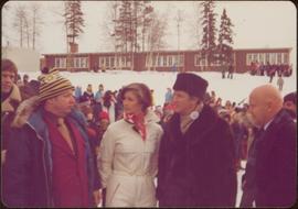
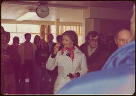
Handwritten annotation on verso reads: “Northern BC Winter Games ’77 Prince George”.
Photograph depicts crowd of people in foreground near log fence. More crowds can be seen in distance at base of ski jump on either sides of the run. Jump visible at top of tree-covered hill in background. It is believed that this photograph was taken near the current location of City Hall.
Photograph depicts railway crossing in front of tent buildings. Dirt road in foreground, forest trees in background. Photograph speculated to have been taken in a construction camp at Prince George.
Photograph depicts lane in front of tent buildings flooded with water, forest trees in background. Photograph taken from canoe, portion of canoe visible in foreground. It is believed that this photograph may depict the Island Cache in flood, at Prince George, BC.
Photograph depicts lane in front of tent buildings flooded with water. Tree in midground, forest trees in background. A man can be seen between first and second row of tent buildings. Photograph taken from canoe, portion of canoe visible in right foreground. It is believed that this photograph may depict the Island Cache in flood, at Prince George, BC.
Image depicts Highway 97 at 15th Ave. looking north. Map coordinates 53°54'36.0"N 122°46'55.5"W
Image depicts a group of individuals on the sidewalk outside Spee-Dee Printers on Brunswick Street in Prince George, B.C.
Image depicts a woman, wearing clothes reminiscent of traditional First Nations, who appears to be dancing in the street outside of a Native Friendship Centre in Prince George, B.C. A large crowd is looking on.
File consists of a transcript of an oral history interview with Terry Johnson.
File consists of a transcript of an oral history interview with Ralph Spoklie.
Item is a hand drawn and coloured map by the City of Prince George Planning Department depicting the North Nechako and Hart neighbourhood area proposed land use in 1976.
Item is a hand drawn and coloured map by the City of Prince George Planning Department depicting existing land use for the Van Bow neighbourhood area.
Item is a map depicting a future medium density development plan for the Peden Hill neighbourhood in Prince George.
Item is Map 2 of a group of five maps relating to a City of Prince George Study of Construction Aggregates by the firm Willis, Cunliffe, Tair & Company Limited. Map 2 shows development areas and aggregate requirements for 1984 and 1994. As the map is undated, it is unclear whether the 1984 and 1994 dates are future estimates.
Item is Map 5 of a group of five maps relating to a City of Prince George Study of Construction Aggregates by the firm Willis, Cunliffe, Tair & Company Limited. Map 5 shows drill hole locations.
This map is part of Schedule B of the 1993 Official Community Plan, Bylaw No. 5909 for the City of Prince George. This particular map depicts the central area of the City of Prince George, including the Bowl area, the VLA, the Crescents, South Fort George, Heritage, and Peden Hill.
This map is part of Schedule B of the 1993 Official Community Plan, Bylaw No. 5909 for the City of Prince George. This particular map depicts the northwest area of the City of Prince George, including the North Nechako neighbourhood and the Hart.
This map is part of Schedule B of the 1993 Official Community Plan, Bylaw No. 5909 for the City of Prince George. This particular map depicts the southwest area of the City of Prince George, including College Heights, UNBC, University Heights, and Vanway.
This map is the May 2006 amendment (Bylaw 7807) of the Schedule C of the 2001 Official Community Plan, Bylaw No. 7281 for the City of Prince George. This Schedule C map shows the long range land use for the City of Prince George.
Postcard photograph depicts lofty view of sternwheeler in river. Scattered buildings and tents in background, river and shore in foreground. Printed annotation on recto reads: “South Fort George Oct 30th 1910”
Photograph depicts lane in front of tent buildings flooded with water, and a man standing near doorway to first building. It is believed that this photograph may depict the Island Cache in flood, at Prince George, BC.
Printed annotation on recto reads: “Central Avenue Fort George B.C. Copyright Canada June 25th 1913”. Handwritten annotation in ink on recto reads: “Hotel Fort George; Pool room; Men’s furnishing; General store; Bank Vancouver; Telephone office; Temperance House; Trust-company; Grand stand & fair grounds; Hospital; Ware house and general store.” Cancelled 1 cent Canadian stamp on verso is dated: "Fort George BC Jul 14 13". Handwritten message in ink on verso is addressed to Mr. Chas H Wilson 94 Gould St Toronto: "Fort George. B.C> Box 65, July 13/ 13. Dear Father, This is a 'bird's eye view' of our main street - ha! ha! some class alright. We live right behind the bakery lunch room on the right hand side of the picture, on 1st avenue, some people eh? Will be moving to Cassiar Ave soon. How are all the folks. Mae is writing. Peace. M."
Boardwalk in foreground, buildings and roads in mid ground, cut banks in background. Printed annotation on recto reads: “Prince George. B.C. 1921 by Moore”. Handwritten annotation in ink on verso reads: “The Netchaco river is between the mountain and the city and the C.N.R. runs along the river bank nearest the city. This picture is taken looking north.”
Street scene in Prince George B.C. Several Union Jack flags are visible and there is a celebration banner at the end of the street. Long shadows in photo indicate summer (perhaps Dominion Day?). River in foreground, railroad and city in mid ground and hill in background. Printed annotation on recto reads: “Prince George. B.C.”
Street view photograph of a commercial section in downtown Prince George with several "Campbell's" delivery carts parked along the road. Visible establishments include "Campbell's All Cash Store" and "Club Cafe." Handwritten annotation in blue ballpoint pen on recto reads: "Howdy from Prince George! Going easy with all these kids- good to see Kathee. Snow here. Have fun at the sports show & don't over do it. Thinking of you guys, love Judy and Vic. P.S. Can't wait to go home to somewhere peaceful and quiet. 2-27-83." Postcard is addressed to: "Mr. & Mrs. Hauffer 8429-221 PL. Sn. Edmonds, WA. U.S. 98020." Verso is affixed with four Canadian 8-cent stamps.
Photograph depicts landscape with cleared land in foreground, river in middle, building and trees in background.
Handwritten annotation on verso: "Central Fort George 1911".
Photograph depicts two connected buildings; the building on the left is possibly the theatre, other building with sign that reads: "The Nechaco (sic?) General Stores." Boardwalk with people and unpaved street in foreground.
Water and dock in foreground, trees and cliffs in background.
Handwritten annotation on verso “’Boat Hammond at South Fort Geroge”.
File consists of a transcript of an oral history interview with Bob Harkins/
File consists of a transcript of an oral history interview with Myra and Glen Hooker.
File consists of a transcript of an oral history interview with Ivan and Bev Westerland.
File consists of a transcript of an oral history interview with John Broderick.
File consists of a transcript of an oral history interview with John Gaal.
Item is a hand drawn and coloured map by the City of Prince George Planning Department depicting zoning proposed by the Prince George City Planner for the VLA neighbourhood.
Item is a map depicting the Vancouver Carney study neighbourhood area in Prince George.
Item is the Proposed Land Use Map, 1978-2012, referred to in By-law No. 3138, the City of Prince George Official Community Plan. The original draft of this map was completed on October 24, 1977. This version of the map was amended in July 1982.
This map is part of Schedule B of the 1993 Official Community Plan, Bylaw No. 5909 for the City of Prince George. This particular map depicts the east area of the City of Prince George, including the Prince George Airport (YXS) and the Blackburn area.
This map is the Schedule A accompanying map for the City of Prince George's Soil Removal and Deposit Bylaw No. 7022 of 1999. It depicts designated soil removal areas and M.O.T.H. gravel reserves.
This map is Schedule C of the 2001 Official Community Plan, Bylaw No. 7281 for the City of Prince George. This Schedule C map shows the long range land use for the City of Prince George.
Photograph depicts group of men and women eating on deck attached to unknown house. Photo believed to have been taken during event held to celebrate Bridget Moran receiving an Honourary Law Degree from the University of Northern British Columbia in Prince George, B.C.
File consists of photocopies of 1960s records from the City of Prince George related to Island Cache that were organized by researchers involved with the Island Cache Recovery Project. Includes an Urban Renewal Report and municipal memoranda.
Sloped banks visible across the Nechako River in background. It is believed that this photograph was taken from Connaught Hill. Tree silhouetted in right foreground.
Photograph features the hotel on George Street, Prince George BC. Handwritten annotation on verso of photograph reads: "Xmas [1948?]", on recto: "From Mr. & Mrs. Fask Douglas." Poem on verso reads: "May Christmas Joy And all its cheer Be yours throughout A good New Year".
Handwritten annotation on verso of photograph: "PRINCE GEORGE B.C. FARMERS TAKING DELIVERY OF CATERPILLAR TRACTORS." Bob sits on first tractor in line of three. Fifteen men stand in a line against street buildings. "THE SALVATION ARMY" building stands in background on right. This photograph was taken at the corner of 4th and George St.
Photograph depicts crowd gathered to watch a baseball game in rustic field. Handwritten annotation on recto reads: “BASE-BALL FORT GEORGE BC” added annotation in ink reads: “1910”.
Photograph depicts Hotel Fort George with people, cars and power pole in foreground. Handwritten annotation on verso reads: “Hotel Fort George - 1913”.
Street scene showing people, dog, team of horses & wagon. Signage reads: “Beds; Mecca Café; Hardware.” Printed annotation on recto reads: “Hamilton Avenue, South Fort George, B. C. No. 110.” Verso displays cancelled 1 cent Canadian Postage Stamp and handwritten message in ink is addressed to Mr. Eathan Villard Burt Mish, U.S.A.
Photograph of Prince George Hotel with several early model cars and a few people. Printed annotation on recto reads: “Hotel Prince George, Prince George, B. C.”
Photograph of George Street in Prince George B.C. Cars, people, and signage are visible. Printed annotation on recto reads: “George St. Prince George B.C. 1921 R7 by Moore” There is an “X” in ink over the fire hall. Handwritten annotation in ink on verso reads: “This view is also looking north and where I have put the X is the one and only fire hall and you can see the fire engine in the street. This is the main street.”