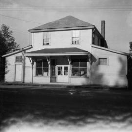
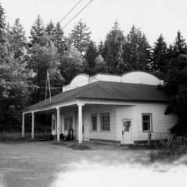
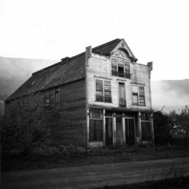
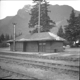
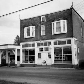
Photograph depicts the post office, store, and gas pump in Clayburn, north of Abbotsford, B.C.
Photograph depicts the Buckingham Apartments at 925 Cardero St.and Barclay St. in Vancouver, B.C.
Photograph depicts a girls' school, Strathcona Lodge, at Shawnigan Lake.
Photograph depicts an abandoned church at Extension, B.C., west of Nanaimo.
Photograph depicts a former store on main street in Pitt Meadows in the Fraser Valley.
Photograph depicts a former service station on the main street of Pitt Meadows in the Fraser Valley.
Photograph depicts the catholic church at Cobble Hill on Shawnigan Lake.
Photograph depicts a west end fire hall in Vancouver on Nelson and Nicola St.
Photograph depicts a church on a reservation at Mosquito Creek in North Vancouver, B.C.
Photograph depicts the fire hall in Moyie, 20 miles south of Cranbrook. When the photo was taken there were 2 hose reel carts inside, a hose, and huge log stove under the hose drying tower (partially seen through window). Moyie was a prosperous village about 1900-1910.
Photograph depicts a courthouse at Revelstoke, B.C. that was built in 1912-1913.
Photograph depicts a possibly derelict hotel in Slocan City, 25 miles northwest of Nelson. Slocan City was once famous for its silver, lead etc. mines.
Photograph depicts an abandoned log cabin in the Kettle Valley between Rock Creek and Westbridge, on the east side of the road approximately 5 miles from Rock Creek.
Photograph depicts a derelict shop on what was the Main St. of Slocan City.
Photograph depicts one of the earlier brick buildings beside the river, sited opposite the sternwheeler landing pier. It is called Commercial Block and was built in 1897.
Photograph depicts the Buckingham Apartments at 925 Cardero St. in Vancouver, B.C. after a snowfall. The view is looking south and depicts Barclay St. crossing in the foreground.
Photograph depicts the Sun Building at the intersection of Beatty and West Pender St. in Vancouver, B.C. The photo was taken after the Pacific Press Ltd. Vacated the building on December 26, 1965, and the "Sun" neon sign on the tower was removed. The view is looking west from West Pender St.
Photograph depicts a shop on the north side of Main St. in Cumberland on Vancouver, Island.
Photograph depicts the Mission City CPR depot located at mile 87.3 from North Bend in Cascade Substation. It was built in 1902 and add onto in 1909. It has living quarters on the 2nd floor that are still in use, which is quite rare for BC in 1973.
Photograph depicts a CPR storehouse at Mission City. It was marked as "Petroleum Store" but in fact was holding speeders and miscellaneous track equipment. It was sited on the north side of the track at the extreme east end of the depot platform.
Photograph depicts the CPR depot at Salmon Arm. It is occupied and in use. The view is looking east.
Photograph depicts the CPR at the Huntingdon/Sumas border (BC/Washington State border). A Mission way freight train is standing at about 5 pm, ready to return to Mission. The photo shows CP caboose #436733, built in 1920 out of wood. The border is about 10 ft. behind the camera.
Photograph depicts the joint CPR and CN depot at Vernon. The depot office had three employees working inside. Vernon is at mile 46.2 from Sicamous, on the Okanagan Subdivision of the CPR. It has daily way freight.
Photograph depicts the CPR depot at Armstrong. It is located about mile 32 from Sicamous on the Okanagan Subdivision. The view is looking south.
Photograph depicts the derelict CPR depot at Hope, part of the former Kettle Valley line. A spur of about 3 miles still exists between the Odlum junction with the main line on the north side of the Fraser River and this depot, and continues southeast to a point near the CNR. It is not abandoned, but little used. The Hope yard has a 47 car capacity.
Photograph depicts the interior of a snow shed at about mile 29.0 using CPR mileages commencing at Brookmere, which is 4 miles east of Brookmere. It is on the ex CPR Coquihalla Line from Hope to Brodie Junction.
Photograph depicts the CPR line at Brookmere, 30 miles south of Merritt (now mile 108.7 on the Princeton Subdivision). Summit point is at 3200 ft. between Spences Bridge, Hope, and Princeton. The Kettle Valley Railway carved out a railway town in the wilderness in 1914/1915 to hold about 300 people. The men were train crews and track a gangs, particularly for the troublesome Coquihalla route. The photo includes the boarded up depot and the view is looking north.
Photograph depicts an abandoned water tower on CPR line at Brookmere, 30 miles south of Merritt. The trackage on the right has had the spikes removed but the yard consists of a mixture of completely removed, partially removed, and completely undisturbed track. An elderly couple and 2 elderly bachelors are the only year-round remaining inhabitants.
Photograph depicts the CPR depot at Merritt. When the Spences Bridge to Merritt branch line was first built its principal traffic was coal taken from the mines on the south edge of the city. As late as 1923 Middlesborough Mine produced 75,862 tons/year.
Photograph depicts the CPR Osoyoos station and the arrival of the daily (except Sunday) way freight train from Penticton. The depot is at about mile 36.1.
Photograph depicts the CPR line at Osoyoos at the BC Tree Fruits Ltd. warehouse and spur. This is about 1 mile north of the depot. The daily freight train from Penticton is returning from Osoyoos, having just collected 1 boxcar of fruit, backing onto caboose. This is approximately at mile 35.4 from Penticton.
Photograph depicts Myra depot on the CPR Kettle Valley line. The depot is at mile 83.8 and is only 8 miles from Kelowna but 2800 ft. above it. Trevor Davies, aged 8 3/4, is in the foreground.
Photograph depicts houses being demolished on Beach Ave, West End, Vancouver.
Photograph depicts a well cared for house that was empty and being stripped along with 3 other house on Barclay to make way for a high rise apartment block. Built circa 1905.
Photograph depicts a house that at the moment was being pushed up on its side by a bulldozer.
Photograph depicts a house on 10th Ave., Vancouver.
Photograph depicts a large house that was actually the Sunset Beach Lodge. The western end of the block was being demolished. Image captured the last complete block of houses on Beach Ave.
Photograph taken looking northwest at a corner house and another home to its left. They were 2 of 9 houses in this Beach Block, the last block of houses on Beach Ave.
Photograph depicts a house that had just been repainted on the north side of Pender Street.
Photograph depicts one of the few remaining inhabioted and well kept houses that still survived in the very heart of downtown Vancouver.
Photograph depicts an Independent Order of Foresters 1895 house.
Photograph depicts one of the four houses on the corner of Barclay and Nicola. It was being demolished to make way for high rise apartments.
Photograph depicts the post office in Union Bay. It was a "Heritage" building and internally restored. Believed to have been built in 1908.
Photograph depicts a one roomed school that was seemingly still in use.
Photograph depicts HMCS Discovery Naval Reserve headquarters in located on Deadman's Island, Vancouver.
Photograph depicts the Department of National Defence Armoury headquarters of the British Columbia regiment.
Photograph depicts a courthouse in Richfield, 1 mile above Barkerville. It was the only building left standing of the former mining community.
Photograph depicts one of the churches on Denman Island.
Photograph depicts a church that was built of shaped logs on the territory of the Tsal'alh Nation on the road leading to Seton Lake. Church was derelict, but still held pews, plastic flowers and small shrines.