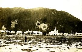
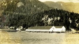
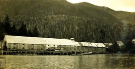
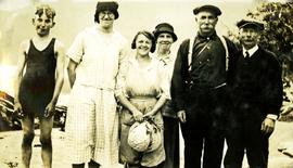
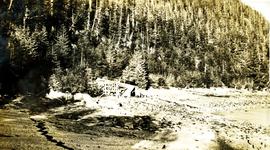
Mostrar 89 resultados

Archival description
74 resultados com objetos digitais Mostrar resultados com objetos digitais
2009.7.1.045 · Item · [1903?]
Parte de Archdeacon W. H. Collison fonds

Three men stand in centre, each wearing a chief's dress and head-dress. Family members stand and sit on either side. Carved boxes and masks are positioned in foreground. The group poses in front of drapery hung against tall wooden wall.

Community members have stated that the people in this photo are from the Gitwilluyaxw clan from the wolf tribal house of Ksdiyaawak. The photo was taken at Gitlax̱t’aamiks along the Nass River.

Handwritten annotation on verso reads: "Tsimpshian Chiefs & family. Goods [for or fr.] Potlatch".

Chief's lodge and totem, Nass River, BC
2009.7.1.104 · Item · [ca. 1878 - ca. 1915]
Parte de Archdeacon W. H. Collison fonds

Photograph depicts two men standing at base of totem pole in front of large elaborate lodge building with post reading "MINESQU". Smaller structure stands in background (elevated cache?).

Handwritten annotation on verso reads: "Chapter XXIV. No. 3. A chief's lodge and totem Nass River."

2009.7.1.137 · Item · [ca. 1910?]
Parte de Archdeacon W. H. Collison fonds

Three men can be seen on deck of small boat. Rocky shore in foreground, forest and hills on opposite shore in background.

Handwritten annotations on verso read: "Dad - en route up Nass River on official business. (hence the flag & business suit!)"; "Going up the Nass. Dad (Indian Agent) Cap Barry (Inspect. of Schools) travelling up the Nass River to Aiyansh".

2023.7.2.04 · Dossiê/Processo · May 1984
Parte de Grant Hazelwood fonds

File consists of a copy of "Preliminary Environmental Assessment of Railway Corridor Options to Service Mount Klappan Coal Project and the Northwest Region of British Columbia" (1984) by the Industrial and Energy Project Evaluation Section, Planning and Assessment Branch of the BC Ministry of Environment.

Capability classification for Bowser Lake
2023.7.2.09 · Dossiê/Processo · 1986
Parte de Grant Hazelwood fonds

File consists notes, correspondence, summary reports, inventory data, and a map regarding capability classification for Bowser Lake. The map is a "clean copy" of Grant Hazelwood's ungulate biophysical map without symbols. Summary reports include:

  • Grant Hazelwood, "Ungulate Capability Classification"
  • Grant Hazelwood, "Winter Flights, February 1986"
  • "Ungulate Biophysical Mapping in the Stikine-Iskut Area"
Three women standing on a boardwalk
2009.21.27 · Item · [ca.1932]
Parte de Thomas Crosby Mission Ship Photograph Collection
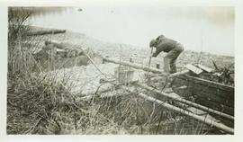
Three women, two wearing hats and pants and one in a dress, stand together in front of what is possibly the Hudson's Bay Store. The woman on the left is Mrs. Huston, wife of the Hudson's Bay Company store manager. Handwritten annotation on verso reads: "Light House caretakers, wife in centre, Lady with cap on, wife of ....the Hudson Bay Store at 1932 ."

Cannery at Nass Harbour
2009.10.1.42 · Item · [July 1926]
Parte de Fred Jeffery Photograph Collection

Photograph depicts a cannery built on pilings, dense forest in the background. Handwritten annotation below photograph reads, "Cannery at Naas Harbour".

"Hagaga : Special Edition"
2009.7.4.11 · Item · April 1895
Parte de Archdeacon W. H. Collison fonds

Newspaper consists of the recto and verso of 2 pages (p. 1-4). It was published in Aiyansh on the Nass River in British Columbia in April 1895 and presents a missionary's perspective of regional First Nations traditions and current affairs of the day.

2009.7.1.140 · Item · [ca. 1925?]
Parte de Archdeacon W. H. Collison fonds

Group of six men sit and stand on small boat close to shore. Rev. W.E. Collison stands on far right (son of Marion and Archdeacon W.H. Collison).

Handwritten annotation on verso reads: "Dr. Macdonald Med officer (Kincolith) / Dr. [McQuarrie?] Med officer Victoria / Steven Clayton Native boat owner / Capt. Bary - Insp. of Indian Schools / W.E. Collison Indian agent. / Inspection trip to villages of upper Nass River".

'Place of Echoes' at Kincolith, BC
2009.7.1.150 · Item · [ca. 1878 - ca. 1915]
Parte de Archdeacon W. H. Collison fonds

Photograph features a steep cliff across water, rocky shore in foreground.

Handwritten annotation on verso reads: "Up the 'Big Creek' at Kincolith B.C. Rock face called 'the place of echoes' by the Indian people."

Upper Nass Assessment Project notes and correspondence
2023.7.2.02 · Dossiê/Processo · 1984-1986
Parte de Grant Hazelwood fonds

File consists of Grant Hazelwood's notes and collected correspondence created in conjunction with the BC Ministry of Environment's "Upper Nass Assessment Project", a project that included the biophysical mapping of the Northwest-Klappan Road Access Area. Includes a summary document entitled "Klappan Access Road Project - Wildlife Component", as well as Hazelwood's handwritten species inventory notes.

"Mount Klappan Anthracite Project"
2023.7.2.05 · Dossiê/Processo · Oct. 1984
Parte de Grant Hazelwood fonds

File consists of an original "Mount Klappan Anthracite Project" document by Gulf Canada Resources Ltd. Includes accompanying map entitled "Gulf Canada Resources Inc.: Northwest British Columbia" that shows proposed coal mine sites in the Mount Klappan area, near Spatsizi Wilderness Park and Tatlatui Provincial Park.

"Mount Klappan Access Road Study"
2023.7.2.06 · Dossiê/Processo · Apr. 1985
Parte de Grant Hazelwood fonds

File consists of an original "Mount Klappan Access Road Study" proposal for consulting services to the BC Ministry of Industry and Small Business Development by Phillips Barratt Kaiser Engineering Ltd. in association with Associated Engineering (B.C.) Ltd.