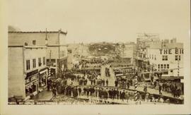
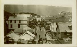
Photograph of Centre Street in Prince Rupert on Dominion Day. The Union Bank of Canada is located on the left side of the street, and a decorative arch can be seen in the background. Annotation on recto reads: "Centre Sr. Prince Rupert Dominion Day Celebrations 1909 Allen Photo July 09."
Photograph of a small marching band parading down Second Avenue in Prince Rupert. A large crowd is gathered. Annotation on recto reads: "Photo by MacRae Bros Prince Rupert BC 2nd Ave Prince Rupert BC."
Photograph of several floats parading down Second Avenue in Prince Rupert. A large crowd is gathered. Annotation on recto reads: "Photo by MacRae Bros Prince Rupert BC Prince Rupert B."
Photograph of a stone monument atop a small hill on a forested shoreline. Annotation on recto reads: "Alexander Mackenzie Monument, Dean Channel, Near Ocean Falls, BC."
Photograph of a young girl believed to be Katy Collison seated for a formal portrait on a wheeled chair. Handwritten annotation in pen on recto reads: "With love from 'Mama'[?] 1907." Handwritten address on verso reads: "Miss West[?] Metlakatla British Columbia N.W. America." Two half penny stamps affixed on verso and partially obscured by two postmarks which read: "Folkstone 1.15 PM SP 19 07."
Photograph of an illustration of an elderly man peering over a photograph of Prince Rupert, BC with a magnifying glass. Beaded leather tassels are affixed to the edges of the illustration. Printed annotation on recto reads: "Taken in 1911. And Today The Eyes of the World are on Prince Rupert. Craig N of Prince Rupert."
Totem poles (crest poles?) stand in front of a line of houses. Sandy beach in foreground, forest on hill in background.
Handwritten annotation on verso reads: "Kai sun W. Coast Q.C.I."
Totem poles (crest poles?) stand in front of wood building, hills visible in background.
Handwritten annotation on verso reads: "Poles on QC Isl."
Totem poles (crest poles?) stand in front of forest trees, fallen logs on beach in foreground.
Handwritten annotation on verso reads: "Indian Totems along beach on Q.C. Islands"
Totem poles (crest poles?) stand in front of remains of wood structures, forest visible in background.
Handwritten annotation on verso reads: "A deserted Village, Q.C. Islands [...]" (various notes crossed through on verso).
Totem poles (crest poles?) stand in front of remains of wood structures built along sandy shore. View from above, forest on hill in background.
Handwritten annotation on verso reads: "[? illegible] Deserted village West Coast QCIs."
Photograph depicts two connected buildings; the building on the left is possibly the theatre, other building with sign that reads: "The Nechaco (sic?) General Stores." Boardwalk with people and unpaved street in foreground.
Image depicts the Fort George Regional Museum in Prince George, B.C.
Image depicts the Lheidli T'enneh Burial Grounds in Fort George Park.
Image depicts the Two Rivers Art Gallery in Prince George, B.C.
Image depicts a building which is a part of the Studio 2880 Arts Complex on 15th Avenue in Prince George, B.C.
Image depicts the Wells Museum in Wells, B.C.
Image depicts the historical village of 'Ksan near Hazelton, B.C.
Image depicts a totem pole in the historical village of 'Ksan near Hazelton, B.C.
Image depicts a group of people in the historical village of 'Ksan near Hazelton, B.C.
Image depicts numerous totem poles in Kispiox, B.C.
Image depicts a large gathering of people in the interior of a First Nations' longhouse located in the historical village of 'Ksan in Hazelton, B.C.
Image depicts the 'Ksan historical village in Hazelton, B.C.
Image depicts the public library in Hazelton, B.C.
Image depicts numerous totem poles in Kispiox, B.C.
Image depicts the historical village of 'Ksan in Hazelton, B.C.
Image depicts the Battle Hill National Historic Site in Kitwanga, B.C.. The sign located there says: "The small knoll in the valley was a native fortress. Legends maintain that it was man-made: built to repel marauding coastal tribes. The hill was the scene of local tribal battles, and at one time was crowned with the defenders' buildings. Known as Dhawdezp, the unique mound is a prominent feature in the legends and history of the Indian people."
Image depicts two totem poles in Skeena Crossing, B.C.
Image depicts an old, partially burnt totem pole in Kispiox, B.C.
Image depicts a totem pole beside the grave marker of the Chief Lu-dal-da-zuatz, in Kispiox, B.C.
Image depicts the entrance to the historical village of 'Ksan in Hazelton, B.C.
Image depicts a street, possibly in Kamloops, which has been closed for a Sunday morning Farmer's Market.
Image depicts a representation of the crucified Christ in the St. Joseph's Roman Catholic Church in Kamloops, B.C.
Image depicts a row of totem poles in Kitwanga, B.C.
Image depicts a totem pole in Kitwanga, B.C.
Image depicts a row of totem poles in Kitwancool, B.C.
Image depicts several old totem poles on their sides in Kitwancool, B.c.
Image depicts a totem pole in Kitwancool, B.C.
Image depicts the Omineca Museum in Manson Creek, B.C.
Image depicts an old Hudson Bay Company house, with a totem pole in the foreground, in Kitwanga, B.C.
Image depicts an unknown woman pointing towards some faded First Nations' rock paintings.
Image depicts a faded First Nations' rock painting.