Showing 4534 results

Archival description
3113 results with digital objects Show results with digital objects
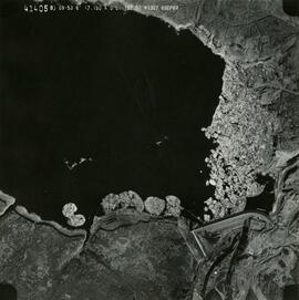
2019.10.4.41405 · Item · 8 Sept. 1969
Part of Lockwood Survey Corporation Ltd. collection

This remote-sensing aerial photograph was taken by Lockwood Survey Corporation Ltd. under contract for the B.C. Forest Service. This historically important aerial photograph depicts the W.A.C. Bennett Dam and Williston Reservoir soon after its flooding in 1968.

The identification coding on these photographs can be interpreted as follows:

  • The largest number on the leftmost side is the frame number for the photograph.
  • The following code to the right in the format B) 69-53 is currently unknown, but may refer to an internal project number for the Lockwood Survey Corporation.
  • The 6" may refer to the camera's focal length in inches.
  • Next is "17,150 ASL" which is 17,150 feet Above Sea Level.
  • Following is "152.52" which refers to the camera's focal length in millimeters, which equals 6 inches.
  • The "W1307" may refer to the reel, but that is unconfirmed.
  • "8 SEP 69" is the date the photo was taken.
2019.10.9 · File · 1 Aug. 1970
Part of Lockwood Survey Corporation Ltd. collection

These remote-sensing aerial photographs were taken by Lockwood Survey Corporation Ltd. under contract for the B.C. Forest Service. Some photographs are annotated to show logging activity; clearcuts, slash piles, log booms, and tree debris on the water are also visible in some of the images. No detailed location information or index accompanies the photographs. These historically important aerial photographs depict Williston Lake soon after its creation in 1968 with the building of the W.A.C. Bennett Dam on the Peace River. Also depicted are the rivers and tributaries that empty into the Williston Reservoir, such as the Finlay River, the Ospika River, and the Omineca River.

The identification coding on these photographs can be interpreted as follows:

  • The largest number on the leftmost side is the frame number for the individual photograph.
  • The following code to the right in the format "B) 70-38" is currently unknown, but may refer to an internal project number for the Lockwood Survey Corporation.
  • The 6" may refer to the camera's focal length in inches.
  • Next is "17,150 ASL" which is 17,150 feet Above Sea Level.
  • Following is "152.63" which refers to the camera's focal length in millimeters, which equals 6 inches.
  • The "W1339" may refer to the reel, but that is unconfirmed.
  • "1 AUG 70" is the date the photos were taken.
2019.10.7 · File · 10 Sept. 1969
Part of Lockwood Survey Corporation Ltd. collection

These remote-sensing aerial photographs were taken by Lockwood Survey Corporation Ltd. under contract for the B.C. Forest Service. Some photographs are annotated to show logging activity; clearcuts, slash piles, log booms, and tree debris on the water are also visible in some of the images. No detailed location information or index accompanies the photographs. These historically important aerial photographs depict Williston Lake soon after its creation in 1968 with the building of the W.A.C. Bennett Dam on the Peace River. Also depicted are the rivers and tributaries that empty into the Williston Reservoir, such as the Finlay River, the Ospika River, and the Omineca River.

The identification coding on these photographs can be interpreted as follows:

  • The largest number on the leftmost side is the frame number for the individual photograph.
  • The following code to the right in the format "B) 69-53" is currently unknown, but may refer to an internal project number for the Lockwood Survey Corporation.
  • The 6" may refer to the camera's focal length in inches.
  • Next is "17,150 ASL" which is 17,150 feet Above Sea Level.
  • Following is "152.52" which refers to the camera's focal length in millimeters, which equals 6 inches.
  • The "W1308" may refer to the reel, but that is unconfirmed.
  • "10 SEP 69" is the date the photos were taken.
2019.10.8 · File · 1 Aug. 1970
Part of Lockwood Survey Corporation Ltd. collection

These remote-sensing aerial photographs were taken by Lockwood Survey Corporation Ltd. under contract for the B.C. Forest Service. Some photographs are annotated to show logging activity; clearcuts, slash piles, log booms, and tree debris on the water are also visible in some of the images. No detailed location information or index accompanies the photographs. These historically important aerial photographs depict Williston Lake soon after its creation in 1968 with the building of the W.A.C. Bennett Dam on the Peace River. Also depicted are the rivers and tributaries that empty into the Williston Reservoir, such as the Finlay River, the Ospika River, and the Omineca River.

The identification coding on these photographs can be interpreted as follows:

  • The largest number on the leftmost side is the frame number for the individual photograph.
  • The following code to the right in the format "B) 70-38" is currently unknown, but may refer to an internal project number for the Lockwood Survey Corporation.
  • The 6" may refer to the camera's focal length in inches.
  • Next is "17,150 ASL" which is 17,150 feet Above Sea Level.
  • Following is "152.63" which refers to the camera's focal length in millimeters, which equals 6 inches.
  • The "W1339" may refer to the reel, but that is unconfirmed.
  • "1 AUG 70" is the date the photos were taken.
2019.10.6 · File · 9 Sept. 1969
Part of Lockwood Survey Corporation Ltd. collection

These remote-sensing aerial photographs were taken by Lockwood Survey Corporation Ltd. under contract for the B.C. Forest Service. Some photographs are annotated to show logging activity; clearcuts, slash piles, log booms, and tree debris on the water are also visible in some of the images. No detailed location information or index accompanies the photographs. These historically important aerial photographs depict Williston Lake soon after its creation in 1968 with the building of the W.A.C. Bennett Dam on the Peace River. Also depicted are the rivers and tributaries that empty into the Williston Reservoir, such as the Finlay River, the Ospika River, and the Omineca River.

The identification coding on these photographs can be interpreted as follows:

  • The largest number on the leftmost side is the frame number for the individual photograph.
  • The following code to the right in the format "B) 69-53" is currently unknown, but may refer to an internal project number for the Lockwood Survey Corporation.
  • The 6" may refer to the camera's focal length in inches.
  • Next is "17,150 ASL" which is 17,150 feet Above Sea Level.
  • Following is "152.52" which refers to the camera's focal length in millimeters, which equals 6 inches.
  • The "W1308" may refer to the reel, but that is unconfirmed.
  • "9 SEP 69" is the date the photos were taken.
2019.10.1 · File · 3 July 1968
Part of Lockwood Survey Corporation Ltd. collection

These remote-sensing aerial photographs were taken by Lockwood Survey Corporation Ltd. under contract for the B.C. Forest Service. Some photographs are annotated to show logging activity; clearcuts, slash piles, log booms, and tree debris on the water are also visible in some of the images. No detailed location information or index accompanies the photographs. These historically important aerial photographs depict Williston Lake soon after its creation in 1968 with the building of the W.A.C. Bennett Dam on the Peace River. Also depicted are the rivers and tributaries that empty into the Williston Reservoir, such as the Finlay River, the Ospika River, and the Omineca River.

The identification coding on these photographs can be interpreted as follows:

  • The largest number on the leftmost side is the frame number for the individual photograph.
  • The following code to the right in the format B) 67-326 is currently unknown, but may refer to an internal project number for the Lockwood Survey Corporation.
  • The 6" may refer to the camera's focal length in inches.
  • Next is "17,000 ASL" which is 17,000 feet Above Sea Level.
  • Following is "152.17" which refers to the camera's focal length in millimeters, which equals 6 inches.
  • The "W1245" may refer to the reel, but that is unconfirmed.
  • "3 JUL 68" is the date the photos were taken.
2019.10.2 · File · 8 Sept. 1969
Part of Lockwood Survey Corporation Ltd. collection

These remote-sensing aerial photographs were taken by Lockwood Survey Corporation Ltd. under contract for the B.C. Forest Service. Some photographs are annotated to show logging activity; clearcuts, slash piles, log booms, and tree debris on the water are also visible in some of the images. No detailed location information or index accompanies the photographs. These historically important aerial photographs depict Williston Lake soon after its creation in 1968 with the building of the W.A.C. Bennett Dam on the Peace River. Also depicted are the rivers and tributaries that empty into the Williston Reservoir, such as the Finlay River, the Ospika River, and the Omineca River.

The identification coding on these photographs can be interpreted as follows:

  • The largest number on the leftmost side is the frame number for the individual photograph.
  • The following code to the right in the format B) 69-53 is currently unknown, but may refer to an internal project number for the Lockwood Survey Corporation.
  • The 6" may refer to the camera's focal length in inches.
  • Next is "17,150 ASL" which is 17,150 feet Above Sea Level.
  • Following is "152.52" which refers to the camera's focal length in millimeters, which equals 6 inches.
  • The "W1307" may refer to the reel, but that is unconfirmed.
  • "8 SEP 69" is the date the photos were taken.
2019.10.3 · File · 8 Sept. 1969
Part of Lockwood Survey Corporation Ltd. collection

These remote-sensing aerial photographs were taken by Lockwood Survey Corporation Ltd. under contract for the B.C. Forest Service. Some photographs are annotated to show logging activity; clearcuts, slash piles, log booms, and tree debris on the water are also visible in some of the images. No detailed location information or index accompanies the photographs. These historically important aerial photographs depict Williston Lake soon after its creation in 1968 with the building of the W.A.C. Bennett Dam on the Peace River. Also depicted are the rivers and tributaries that empty into the Williston Reservoir, such as the Finlay River, the Ospika River, and the Omineca River.

The identification coding on these photographs can be interpreted as follows:

  • The largest number on the leftmost side is the frame number for the individual photograph.
  • The following code to the right in the format B) 69-53 is currently unknown, but may refer to an internal project number for the Lockwood Survey Corporation.
  • The 6" may refer to the camera's focal length in inches.
  • Next is "17,150 ASL" which is 17,150 feet Above Sea Level.
  • Following is "152.52" which refers to the camera's focal length in millimeters, which equals 6 inches.
  • The "W1307" may refer to the reel, but that is unconfirmed.
  • "8 SEP 69" is the date the photos were taken.
2019.10.4 · File · 8 Sept. 1969
Part of Lockwood Survey Corporation Ltd. collection

These remote-sensing aerial photographs were taken by Lockwood Survey Corporation Ltd. under contract for the B.C. Forest Service. Some photographs are annotated to show logging activity; clearcuts, slash piles, log booms, and tree debris on the water are also visible in some of the images. No detailed location information or index accompanies the photographs. These historically important aerial photographs depict Williston Lake soon after its creation in 1968 with the building of the W.A.C. Bennett Dam on the Peace River. Also depicted are the rivers and tributaries that empty into the Williston Reservoir, such as the Finlay River, the Ospika River, and the Omineca River.

The identification coding on these photographs can be interpreted as follows:

  • The largest number on the leftmost side is the frame number for the individual photograph.
  • The following code to the right in the format B) 69-53 is currently unknown, but may refer to an internal project number for the Lockwood Survey Corporation.
  • The 6" may refer to the camera's focal length in inches.
  • Next is "17,150 ASL" which is 17,150 feet Above Sea Level.
  • Following is "152.52" which refers to the camera's focal length in millimeters, which equals 6 inches.
  • The "W1307" may refer to the reel, but that is unconfirmed.
  • "8 SEP 69" is the date the photos were taken.
2019.10.5 · File · 9 Sept. 1969
Part of Lockwood Survey Corporation Ltd. collection

These remote-sensing aerial photographs were taken by Lockwood Survey Corporation Ltd. under contract for the B.C. Forest Service. Some photographs are annotated to show logging activity; clearcuts, slash piles, log booms, and tree debris on the water are also visible in some of the images. No detailed location information or index accompanies the photographs. These historically important aerial photographs depict Williston Lake soon after its creation in 1968 with the building of the W.A.C. Bennett Dam on the Peace River. Also depicted are the rivers and tributaries that empty into the Williston Reservoir, such as the Finlay River, the Ospika River, and the Omineca River.

The identification coding on these photographs can be interpreted as follows:

  • The largest number on the leftmost side is the frame number for the individual photograph.
  • The following code to the right in the format "B) 69-53" is currently unknown, but may refer to an internal project number for the Lockwood Survey Corporation.
  • The 6" may refer to the camera's focal length in inches.
  • Next is "17,150 ASL" which is 17,150 feet Above Sea Level.
  • Following is "152.52" which refers to the camera's focal length in millimeters, which equals 6 inches.
  • The "W1308" may refer to the reel, but that is unconfirmed.
  • "9 SEP 69" is the date the photos were taken.
Heritage River Trail System
2012.13.2.21.07 · File · 1984-2000
Part of J. Kent Sedgwick fonds

File consists of records created and collected by Kent Sedgwick regarding the Heritage River Trails System and surrounding park areas in Prince George such as Cottonwood Island Park. Highlights include:

  • Full page newspaper feature in The Citizen written by Kent Sedgwick that includes a detailed history of Cottonwood Island Park and the River Trails as well as a contest for naming the trail system (2 Nov. 1984)
  • Graham Farstad, Director of Planning, City of Prince George, "Prince George's Heritage River Trail System" document, May 1986
  • records relating to the dedication plaque for the opening of the trails
  • "Heritage River Trails: A Guide to the Pathways along the Fraser and Nechako Rivers, Prince George, British Columbia" brochures created by Kent Sedgwick
  • map on transparency depicting the Heritage River Trails System
2012.13.2.21.04 · File · 1973-1978
Part of J. Kent Sedgwick fonds

File consists of proposals and documents by Kent Sedgwick regarding Cottonwood Island. Includes: "Proposal for Cottonwood Island as a Park Reserve" and "Some Comments on the Cottonwood Island Park Designation of the Official Community Plan".

2012.13.2.21.03 · File · 1973-2001
Part of J. Kent Sedgwick fonds

File consists of records created and collected by Kent Sedgwick regarding Cottonwood Island. Includes: "Welcome to Cottonwood Island Nature Park" brochure [197-?]; "A Brief History of Cottonwood Island Park" by Kent Sedgwick (2001); "History of Cottonwood Island Park and Side Channel Restoration" (2001?); a Regional District of Fraser-Fort George "Notice of Public Hearing" (1973); an outline for "Cottonwood Island Brief" (1973); an original copy of the "Cottonwood Island Study" by the Regional District of Fraser-Fort George (1975); annotated hand-drawn small maps of Cottonwood Island; photocopied aerial photographs; and photocopied newspaper clippings about Cottonwood Island and Island Cache. Also includes 15 colour photographic prints and accompanying negatives taken of Cottonwood Island by Bob Nelson.

Photographic negatives
2012.13.1.135.02 · File
Part of J. Kent Sedgwick fonds

File consists of a printed email correspondence between Ramona Rose, Florence Smith, and Sue Sedgwick regarding an additional donation of photographic negatives. The file includes photographs depicting photographs of Knox United Church and historic Prince George.

2012.13.2.21.02 · File · 1970-1979
Part of J. Kent Sedgwick fonds

File consists of records created and collected by Kent Sedgwick regarding the removal of Island Cache residents after the 1972 flood and suggestions for creation of park on Cottonwood Island. The majority of the file consists of reproduced City of Prince George records. Includes memoranda to and from the mayor, city manager, and aldermen; meeting minutes of the Flood Committee; city reports on Cottonwood Island and the flooding situation; a listing of Cottonwood Island properties offered for sale to the municipality; a report entitled "Cottonwood Island - A report on desirable land use" (Nov. 1970); a "Proposal for Cottonwood Island as a Park Reserve" (1973); a document from the Cottonwood Island Study Committee; correspondence from Mary Fallis; and a City of Prince George memorandum regarding a Public Hearing.

2012.13.2.21.01 · File · 1983-1991
Part of J. Kent Sedgwick fonds

File consists of records created or collected by Kent Sedgwick relating to various community projects associated with river parks. Example projects included in the file are a proposed Carrier village at Hudson Bay Slough, a Cottonwood Island park, proposed commercial boat tours on the Nechako and Fraser River, and the Quesnel Paddlewheel Park. Includes a project proposal document by the Fort George Band entitled "Establishing a Permanent Carrier Village in Prince George" (1990); a 1991 meeting package of the Nechako and Fraser River Valleys Committee (regarding the Cottonwood Island property and development of the Heritage River Trails System); a 1991 memorandum entitled "Prince George River Runners - Proposed commercial boat tours on the Nechako and Fraser River"; a 1983 "Submission to Rivers Committee Public Hearings by Heritage Advisory Committee, City of Prince George" describing the various river-adjacent heritage sites in Prince George; and documentation from the Quesnel Paddlewheel Association.

2012.13.4.46 · File · 1975
Part of J. Kent Sedgwick fonds

File consists of two original copies (one in English, one in French) of "Peyto Glacier: General Information" prepared by Kent Sedgwick and E.S. Hencock for Environment Canada. Includes attached supplementary map along with each publication. Also includes duplicate original maps in the file.

2012.13.3.3.04 · File · 1994
Part of J. Kent Sedgwick fonds

File consists of typed documents, letters, and reports relating to the Alexander Mackenzie voyageur route near Vanderhoof. Includes: "Nuxalk-Carrier Grease Trail / Alexander Mackenzie Voyageur route" management plan annual report from the Vanderhoof Forest District (Jan.-Dec. 1994) and "RE: Alexander Mackenzie Heritage Trail" letter to the regional managers of the Prince George Forest Region and Cariboo Forest Region and the Director of the Archaeology Branch from Greg Nicoholls, the chair of the Alexander Mackenzie Heritage Trail Coordinating Committee (19 Apr. 1995).

2012.13.3.3.02 · File · 1985
Part of J. Kent Sedgwick fonds

File consists of bound documents, plans, and reproductions. Includes: "Public input summary" spiral bound book from Parks Canada (Dec. 1985) and "Alexander Mackenzie Heritage Trail" bound book published by Parks Canada (17 July 1985).

2012.13.2.19.29 · File · 1972
Part of J. Kent Sedgwick fonds

File consists of a pamphlet titled "The Quesnel-Lillooet Bulletin Area" prepared by the Department of Lands, Forests, and Water Resources from the Province of British Columbia. The pamphlet is a revised 2nd edition published in 1973, the original was published in 1968.

Tweedsmuir Provincial Park
2012.13.2.14.30 · File · 1986-1987
Part of J. Kent Sedgwick fonds

File consists of a book and typescript correspondences. Includes: "Tweedsmuir Provincial Park Background Document" by the Province of British Columbia (1986).

Heritage River Trails
2012.13.2.14.18 · File · 1984
Part of J. Kent Sedgwick fonds

File consists of notes and reproductions relating to the Heritage River Trails in Prince George that follow the shores of the Nechako and Fraser Rivers. Includes: "Heritage River Trails" brochure prepared by Kent Sedgwick (1984).

Prince George rivers
2012.13.2.14.22 · File · 1980-1991, 2006
Part of J. Kent Sedgwick fonds

File consists of notes, clippings, and reproductions relating to rivers in Prince George. Includes: "Proposal for Cottonwood Island as a park reserve" typescript document by the New Caledonia Institute of Environmental Studies [ca. 1980]; "Ministry of Provincial Secretary and Government Services" typescript letter from John McMurdo to Graham Farstad (15 Dec. 1982); "Rip-rap for Goat Island" typescript letter from Kent Sedgwick to Ernie Obst (23 Oct. 1986); "Ted Williams' river tour notes" typescript document by Ted Williams (June 1991); and "RE: Moffat A.L.R Exclusion and Archaeological Site F1Rq 2" typescript letter from Steve Acheson to Daniel Guerrette (11 May 1982).

Monkman Pass area
2012.13.2.14.24 · File · 1973-2006
Part of J. Kent Sedgwick fonds

File consists of notes, clippings, and reproductions relating to the Monkman Pass area. Includes: "Monkman Pass Memorial Trail" brochure prepared by Tumbler Ridge (2006); "The trail to Monkman Pass" clipped article from BC Outdoors magazine (July 1983); "Regional District of Fraser-Fort George" typescript letter from Y.D. Kennedy to Kent Sedgwick (5 Sept. 1973); and "Alberta Wilderness Association Newsletter" newspaper vol. 13 no. 1 (1983).

2012.13.2.14.19 · File · 2004-2006
Part of J. Kent Sedgwick fonds

File consists of notes, clippings, and reproductions relating to the Volksport trail in Prince George. The trail starts at the Prince George Railway and Forestry Museum and follows the Heritage River Trail through parks along the Fraser and Nechako Rivers with some residential walking. Includes: "Prince George Railway & Forestry Museum 11 km trail for Volkssporting members" typed document (2004) and "Presentation for Railway and Forestry Museum Directors Meeting" typed document by Audrey L'Heureux (Jan. 2004).

2012.13.2.14.08 · File · 1985-2000
Part of J. Kent Sedgwick fonds

File consists of notes, clippings, and reproductions relating to the planning of Millennium Park at First Avenue and George Street in Prince George. Includes: "Cairn at Millennium Park" typed document by Kent Sedgwick (Mar. 2000) and correspondence letters between Kent Sedgwick, The City of Prince George, and Environment Canada (1987).

2012.13.2.14.09 · File · 1987-1989
Part of J. Kent Sedgwick fonds

File consists of notes, reproductions, and letters relating to L.C. Gunn Park in Prince George. Includes: "Signage for Gunn Park" letter from Kent Sedgwick to the Mayor and Council (21 Dec. 1989); "L.C. Gunn viewpoint a proposal" documents within a duotang (1987); and "Donation to the City of Prince George" typescript letter from Graham Farstad to the Administration Committee ( 1 June 1988). Includes photographs depicting the opening of L.C. Gunn Park and the sign unveiling (3 Oct. 1988).

2012.13.2.11.18 · File · 1990
Part of J. Kent Sedgwick fonds

File consists of a report titled "Nechako and Stuart River Corridors" prepared by the Ministry of Forests for the Province of British Columbia. The report has background data and reference information for a recreation planning study of the Nechako and Stuart River Corridors.

2012.13.2.11.10 · File · 1983
Part of J. Kent Sedgwick fonds

File consists of notes, clippings, and reproductions relating to the Prince George Rivers Committee. Includes: "Report of the Rivers Committee" spiral bound typescript reports submitted to City Council of the City of Prince George (26 Sept. 1983) and "Submission to Rivers Committee by Heritage Advisory Committee" typescript document by Kent Sedgwick (Apr. 1983).

Forest fires
2012.13.2.11.14 · File · 1997-2011
Part of J. Kent Sedgwick fonds

File consists of notes, clippings, and reproductions relating to forest fires in Prince George and region. Includes: "Significant Fire Years in the Prince George Area - A Media Perspective Taken from the Prince George Citizen Newspaper (1912-1961)" typed document by Brad C. Hawkes (June 1997).

Interior rainforest
2012.13.2.11.13 · File · 2008
Part of J. Kent Sedgwick fonds

File consists of notes, clippings, and reproductions relating to the central interior rainforest and the Ancient Forest/Chun T'oh Whudujut Provincial Park and Protected Area.

Prince George climate
2012.13.2.11.08 · File · 1984-2005
Part of J. Kent Sedgwick fonds

File consists of notes and reproductions relating to climate in Prince George. Includes: "Annual meteorology summary Prince George, B.C". document from Environment Canada (1989).

2012.13.2.09.03 · File · 1967-2005
Part of J. Kent Sedgwick fonds

File consists of notes, clippings, and reproductions relating to British Columbia historical bibliographies and reference material. Includes: "Rural British Columbia: A Bibliography of Social and Economic Research" typescript document compiled by Dean S. Goard (1967); "Photo chronicler of B.C. a century ago" clipped article from Canadian Photography magazine (Feb. 1977); and "A Guide to British Columbia Stop of Interest Plaques" pamphlet by the Parks Branch of British Columbia (1969).

Agriculture in Prince George
2012.13.2.07.02 · File · 1983-2007
Part of J. Kent Sedgwick fonds

File consists of notes, clippings, and reproductions relating to historical agriculture in Prince George. Includes material on the Prince George Farmer's Institute; experimental plots surrounding Prince George; farming in areas surrounding Prince George including Pineview, Mud River, and Blackburn; ranching; gardening; and the Prince George Experimental Farm. Includes: "Moose in British Columbia, Canada" an educational pamphlet from the Fish and Wildlife Branch of the Department of Recreation and Conservation in British Columbia.

Dairies in Prince George
2012.13.2.07.03 · File · 2004-2006
Part of J. Kent Sedgwick fonds

File consists of notes, clippings, and reproductions relating to dairying and dairy farming in Prince George. Includes material on Harry Moffat; cattle in Mud River; Mr. Hewlett and Centralia Dairy (established in 1923); Interior Creamery, located at the corner of Brunswick and First Avenue; and pasteurization.

Grand Canyon of the Fraser
2012.13.2.03.04 · File · 1995-2004
Part of J. Kent Sedgwick fonds

File consists of notes, clippings, and reproductions relating to the Grand Canyon of the Fraser River. The Grand Canyon of the Fraser is a short gorge on the upper Fraser River, about 6 kilometres south-southwest of Hutton. The canyon head was about 171 kilometres by river from Fort George, and is about 100 kilometres due east of downtown Prince George.