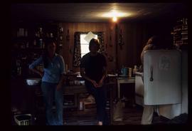
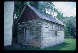
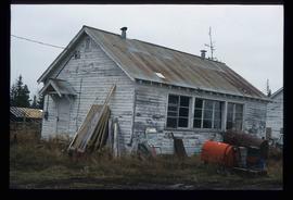
Mostrar 2470 resultados

Archival description
1595 resultados com objetos digitais Mostrar resultados com objetos digitais
Spring House
2012.13.1.52.61 · Item · [1980?]
Parte de J. Kent Sedgwick fonds

Image depicts an old building at an uncertain location. The slide is simply labelled "Spring house."

Lillooet Area
2012.13.1.053 · Subsérie · [between 1971 and 1982]
Parte de J. Kent Sedgwick fonds

File contains slides depicting places in the Lillooet area.

Lillooet - Howe Sound
2012.13.1.054 · Subsérie · [between 1977 and 1987]
Parte de J. Kent Sedgwick fonds

File contains slides depicting places around and between Lillooet and Howe Sound.

Britannia Mine Entrance?
2012.13.1.54.52 · Item · July 1980
Parte de J. Kent Sedgwick fonds

Image depicts the entrance to a mine with an unknown individual present. It is possibly the entrance to the closed Britannia Mine in the Howe Sound Region.

McBride Hotel
2012.13.1.56.80 · Item · 1973
Parte de J. Kent Sedgwick fonds

Image depicts the McBride Hotel near the Mt. Robson Provincial Park.

Hat Creek Ranch - McLean Cabin
2012.13.1.58.05 · Item · June 1987
Parte de J. Kent Sedgwick fonds

Image depicts the McLean Cabin, built in 1861, which belonged to a retired Hudson's Bay Chief trader named Donald McLean, who was shot and killed while part of a posse that was searching for the murderers of a survey party. It is located at the historic Hat Creek Ranch site north of Ashcroft, B.C.

Terzaghi Dam
2012.13.1.59.22 · Item · July 1980
Parte de J. Kent Sedgwick fonds

Image depicts the Terzaghi Dam viewed from the downstream side near Bralorne B.C.

Log Cabin
2012.13.1.2.009 · Item · Nov. 2001
Parte de J. Kent Sedgwick fonds

Image depicts a log cabin, possibly in Beaverly.

Prince George
2012.13.1.3.046 · Item · Jan. 1978
Parte de J. Kent Sedgwick fonds

Image depicts a view of Prince George from City Hall looking northeast along George Street. Map coordinates 53°54'46.3"N 122°44'41.9"W

Central Business District
2012.13.1.3.057 · Item · July 1979
Parte de J. Kent Sedgwick fonds

Image depicts the Central Business District of Prince George looking north from Connaught Hill. Map coordinates 53°54'41.4"N 122°44'58.5"W

Fort George Park
2012.13.1.3.073 · Item · Oct. 1983
Parte de J. Kent Sedgwick fonds

Image depicts the Fort George Park. Map coordinates 53°54'30.2"N 122°43'57.4"W

Prince George
2012.13.1.3.077 · Item · May 1984
Parte de J. Kent Sedgwick fonds

Image depicts downtown Prince George looking northwest. Map coordinates 53°54'48.7"N 122°44'45.6"W

Prince George
2012.13.1.3.078 · Item · May 1984
Parte de J. Kent Sedgwick fonds

Image depicts a view of Prince George from City Hall looking northeast along George Street. Map coordinates 53°54'46.3"N 122°44'41.9"W

Log House
2012.13.1.3.083 · Item · July 1985
Parte de J. Kent Sedgwick fonds

Image depicts the balcony of a log house, likely somewhere in or near Prince George B.C.