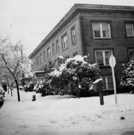
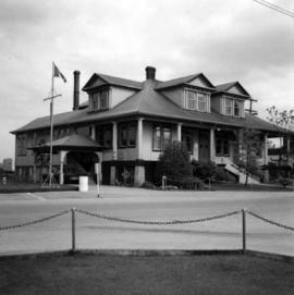
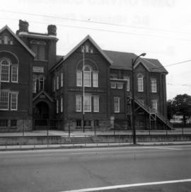
Photograph depicts a former fire hall now used as a boy's club on 12th Ave and St. Catherine's St., in Vancouver, B.C. It is one and a quarter miles southeast of C.N.R. station.
Photograph depicts Pier B of C.P.R., just west of the C.P.R. railway station. This is the only pier accessible to ocean going passenger liners and is used by P&O vessels. Facilities generally in adequate for the 1960s.
Photograph depicts the Sun Building at the intersection of Beatty and West Pender St. in Vancouver, B.C. The photo was taken after the Pacific Press Ltd. Vacated the building on December 26, 1965, and the "Sun" neon sign on the tower was removed. The view is looking west from West Pender St.
Photograph depicts the Pacific Press Ltd. Vancouver Sun building at Beatty and West Pender St. The view is looking northeast from Beatty St. It was vacated by the Vancouver Sun at Christmas 1965 with the neon "Sun" sign on the tower removed.
Photograph depicts the Buckingham Apartments at 925 Cardero St. in Vancouver, B.C. after a snowfall. The view is looking south and depicts Barclay St. crossing in the foreground.
Photograph depicts East Pender St., looking west towards the Vancouver Sun newspaper office near Abbot St. in Vancouver, B.C.
Photograph depicts a fire hall for fire float VFD "J.H. Carlisle" at False Creek. It is on the north shore and in line with Willow St., Vancouver.
Photograph depicts Mainland St. in Vancouver, B.C. , looking northeast with Helmken St. intersecting.
Photograph depicts a former C.P.R. connection between the False Creek yards and the south side of Vancouver harbour on West Pender St. in Vancouver, B.C. This spur used daily to get cars into the B.C. Electric Rail yard at the Georgia Viaduct from the C.P.R. False Creek yards.
Photograph depicts Hamilton St. in Vancouver, looking northeast.
Photograph depicts the site of a former C.P.R. connection between the mainline into Vancouver and False Creek yards at West Pender St. In Vancouver. The rails are not used but still appear in the street and on the parking lot on the far side. Another parallel set of tracks 30 yards to the east are in daily use.
Photograph depicts a church on a reservation at Mosquito Creek in North Vancouver, B.C.
Photograph depicts a corner building on Chilco and West Georgia St. facing Stanley Park in Vancouver, B.C. The view is looking east across Chilco St.
Photograph depicts a west end fire hall in Vancouver on Nelson and Nicola St.
Photograph depicts the corner building on West Georgia and Chilco St., facing Stanley Park in Vancouver B.C. View looking south across Georgia St.
Photograph depicts the Grand Central Hotel at the intersection of Marpole Ave and Hudson St. in south Vancouver. The hotel was built in 1912 by J.J. Graver and run from 1913-1915. It re-opened in 1920 as a home for incurables (veterans). In 1937 it became the provincial infirmary and closed in May 1965.
Photograph depicts the Buckingham Apartments at 925 Cardero St.and Barclay St. in Vancouver, B.C.
Photograph depicts a stone house on 17th St. and Esquimalt St. in West Vancouver, B.C.
Photograph depicts a home at 1310 Comox St. in Vancouver, B.C. View is of the east side of the house, facing Jervis St.
Photograph depicts an old church or school being demolished at 1701-1721 West 3rd Ave. (and Pine), in Vancouver, B.C.
Photograph depicts a home located at 1459 Robson St., at the northeastern intersection of Robson and Nicola, in Vancouver B.C.
Photograph depicts the former C.P.R. route connecting existing False Creek rail yards and the Burrard shoreline main line. The view is looking southwest from the intersection of Powell St. (in foreground) and Columbia St. (not seen) in Vancouver.
Photograph depicts the Mussenden Building used by the Hudson's Bay Company. It is located on Water St. in Vancouver, B.C. View is from the north side looking east.
Photograph depicts the building for the Vancouver Supply Company located at 25 Alexander St. in Vancouver, B.C. It is at the center of the old downtown and may have been a former fire hall.
Photograph depicts the headquarters and general offices of the National Harbours Board in Vancouver, B.C., located at the foot of Dunlery St.
Photograph depicts an old building at 119 Water St. in Vancouver, B.C.
Photograph depicts the former "Terminus Hotel" on 32 Water St., 50 yards from the center of old Vancouver.
Photograph depicts a former Sailor's Home at the southeast corner of the intersection at Alexander St. and Jackson St. in Vancouver, B.C.
Photograph depicts what is believed to be the only remaining "summer cottage" on Beach Ave. in English Bay.
Photograph depicts a bandstand at English Bay in Vancouver, B.C.
Photograph depicts a CNR lifting bridge in Vancouver.
Photograph depicts West Coast Electric Ltd., an electric manufacturers and shop.
Photograph depicts buildings of the former Vancouver-Lansdale ferry. They appeared to now be used by Kingcome Navigation Co. as well as other businesses.
Photograph depicts the demolished site of Nelson Laundries Ltd. The boiler in the foregorund was having tubes removed by a wrecker. The site was to be occupied by a Ford motor dealer.
Photograph depicts the rear view of Ridgewood Studio, Ltd., furnishers and furniture renovators. The wood shed was used for repair and repolishing of furniture.
Photograph depicts a Public Weigh Scale that was operated in Vancouver, on Main Street, opposite the CN Depot.
Photograph depicts an RCAF Langer that was erected in 1942 as part of a flying boat base to counter possible Japanese sea and activities. It was used subsequently as whaling station premises.
Photograph depicts Mount Pleasant Elementary School in Vancouver. Date over doorway was 1892.
Photograph depicts HMCS Discovery Naval Reserve headquarters in located on Deadman's Island, Vancouver.
Photograph depicts the Department of National Defence Armoury headquarters of the British Columbia regiment.
Photograph depicts HMCS Discovery Naval Reserve headquarters in located on Deadman's Island, Vancouver.
Photograph depicts Vancouver City College, formerly King Edward Secondary School.
Photograph depicts the Great Northern Railway station on Main Street, Vancouver being demolished.
Photograph depicts one of the four houses on the corner of Barclay and Nicola. It was being demolished to make way for high rise apartments.
Photograph depicts a house that had just been repainted on the north side of Pender Street.
Photograph depicts one of the few remaining inhabioted and well kept houses that still survived in the very heart of downtown Vancouver.
Photograph depicts a house on the southern edge of Chinatown.
Photograph depicts a house on the east side of Ontario Street, Vancouver.
Photograph depicts a house that had a "sold" notice on it and was partly demolished. Up to the date the photograph was captured, this block on Beach Ave. was the sole remaining one to have only houses on it, as opposed to a mixture of houses and apartment blocks, or blocks only.