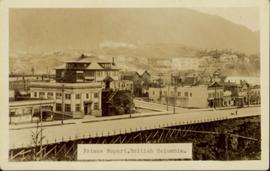
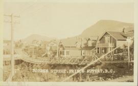
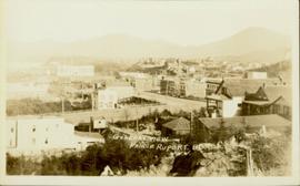
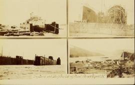
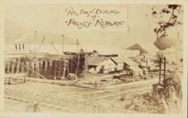
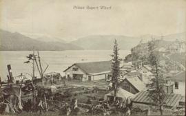
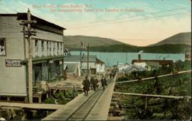
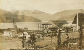
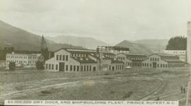
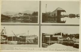
Showing 165 results

Archival description
158 results with digital objects Show results with digital objects
2011.3 · Collection · 1901 - [ca.1930]

A collection of postcard photographs of Port Essington BC, Port Simpson BC, Atlin, Quesnel, McBride, Hagwilget Village, Giscome, Likely, Kitwanga, Smithers, Prince Rupert BC, Prince (Fort) George BC Images depict street scenes, water scenes, community events, businesses, buildings, and aerials of the towns. Collection also depicts a number of Northern BC paddle wheelers.

2011.3.3 · File · 1909 - [ca. 1930]
Part of North Coast & Central BC Postcard Collection

File contains postcards portraying life in Prince Rupert, B.C. Images depict harbour scenes, street scenes (Third Avenue, Sixth Street, Central Street, and Mainstreet), airplanes, large ships, fisheries, city aerials, parades, military, a dog sled mail team, and a frozen fishing boat.

2011.3.3.104 · Item · [ca. 1909-1930]
Part of North Coast & Central BC Postcard Collection

Street view down Centre Street in Prince Rupert, BC. Printed annotation on recto reads: "Centre Street, Prince Rupert, B.C. 1664." Handwritten annotation on verso reads: "Minnie sent a parcel to you by express to-day- some things you left behind you. I hope you and Bertie had a good trip up. Florrie and the children will leave on the morning train. All are pretty well and send their love to you. Harrie." Postcard is addressed to: "Miss M.V. Beattie Enderby, B.C." Verso is affixed with a two cent Canadian stamp. Postmarkson recto and verso are illegible.

Prince Rupert wharf
2011.3.3.108 · Item · [ca. 1909-1930]
Part of North Coast & Central BC Postcard Collection

Lofty view of the buildings along the Prince Rupert wharf with workers unloading a vessel. Water and mountains can be seen in the background. Printed annotation on recto reads: "Prince Rupert Wharf."

2011.3.3.113 · Item · [ca. 1909-1930]
Part of North Coast & Central BC Postcard Collection

Hand coloured photo of Main Street in Prince Rupert, with various tents and buildings on either side of the wooden road. Printed annotation on recto reads: "Main Street, Prince Rupert, B.C. : On comparatively Level Line London to Yokohama." Artist's mark on lower right corner reads: "104,035 J.V."

2011.3.3.89 · Item · [ca. 1909-1930]
Part of North Coast & Central BC Postcard Collection

Photograph of a bridge along a rocky shoreline. Printed annotation reads: "Colloway Rapids Bridge Prince Rupert Highway W.W.W." Handwritten annotation on verso is heavily obscured by residual album paper and reads: "PO Box 777 Prince Rupert BC. [Illegible] Lal. This[??] is a piece of our new bridge which [obscured] neats our Island with the mainland. We have had picnics on the other side & [illegible] is open for [illegible] to [illegible]ve ours this side of the [obscured] our stuff to the little [obscured] patronize[??]. Mrs. [illegible] are back again in Rupert [obscured] Kamloops office closed down [obscured] was no chance of transfer. Have not."

2011.3.3.106 · Item · [ca. 1909-1930]
Part of North Coast & Central BC Postcard Collection

Front view of several commercial buildings in Prince Rupert, BC. Visible are "The Ideal Clothing & Shoe Store," "Bailey and Bell Bakers," and "Hotel Premier." Printed annotation on recto reads: "Prince Rupert, BC." Handwritten annotation on verso reads: "Dear Peggy, Mailui[??] will show you where [illegible] and Dunn Florence [illegible] when you come in Prince Rupert you will see this [illegible]. Aunt Florence." Postcard is addressed to: "Margaret [Illegible] Suby Seabold. Kipap County Washington[??]. Verso is affixed with a Canadian one Cent stamp. Postmarks on verso read: "[Illegible] WASH Sep 6 19[??] Prince Rupert B.C. SP 2 69."

Saw mill in Prince Rupert BC
2011.3.3.118 · Item · [ca. 1909-1930]
Part of North Coast & Central BC Postcard Collection

Hand coloured photo of a clearing in Prince Rupert with a sawmill in the distance. Printed annotation on recto reads: "Prince Rupert, B.C. : Saw Mill Grand Trunk Pacific Railway." Artist's stamp in the lower right corner reads: "103112 J.V."

2008.2.1.15 · Item · 1929
Part of Northern BC Cartographic Collection

Colour-coded map depicting surveyed lands respectively open and closed to preemption. Depicts land recording divisions, land district boundaries, government reserves, communities, bodies of water, and transport routes. Includes topographical inset.