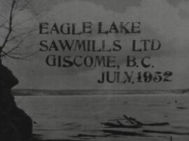
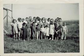
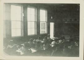
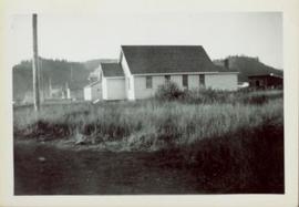
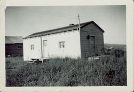
Image depicts the Giscome mill site in Giscome, B.C. The bunkhouse is no longer there and the school is in the foreground on the right. Map coordinates 54°04'04.8"N 122°22'04.7"W
Image depicts the Giscome mill site in Giscome, B.C. The railroad tracks are in the foreground. Map coordinates 54°04'17.6"N 122°22'06.1"W
Image depicts mill site and dock in Giscome, B.C. with Eaglet Lake in the background covered in ice. There is a large crowd of people gathered near the dock. Map coordinates 54°04'34.9"N 122°21'50.0"W
Image depicts a street in Giscome. The store was previously located on the left. The church is in the background. Map coordinates 54°04'18.5"N 122°21'57.7"W
Image depicts the dairy farm in Giscome, B.C. Map coordinates 54°03'53.3"N 122°21'22.6"W
Image depicts Eaglet Lake in the winter taken from Giscome, B.C. Map coordinates 54°04'20.9"N 122°21'53.1"W
Image depicts a house in Giscome, B.C. Map coordinates 54°04'17.6"N 122°22'06.1"W
Image depicts the old CN station in Giscome, B.C. Map coordinates 54°04'20.7"N 122°22'01.1"W
Image depicts an open field and Giscome, B.C. in the background. Map coordinates 54°03'52.9"N 122°22'10.0"W
Image depicts a row of houses at an uncertain location, possibly in Giscome, B.C.
Image depicts what is possibly the CN Railway Station and tracks located in Giscome, B.C.
Image depicts Giscome with the school on the left, the remnants of the town site in the middle and the church on the right. Map coordinates 54°03'58.2"N 122°22'04.8"W
Image depicts a Catholic church in Giscome, B.C. Map coordinates 54°04'15.5"N 122°21'52.1"W
File consists of a transcript of an oral history interview with Ken Sasaki.
File consists of a transcript of an oral history interview with Buster Brown.
This 16mm film of Eagle Lake Sawmills was produced by Torajiro Sasaki in July 1952, likely commissioned or with permission from the sawmill owners, the Spurs. The film depicts logging and sawmilling operations at the Eagle Lake Sawmill, as well as shots of the bunkhouses, exterior shots of the mill, and the beehive burner. Employees of the mill are shown at work. In 1952, Eagle Lake Sawmill used both machinery and horses in their operations.
Sasaki, TorajiroOriginal photographic print included in "Northern Interior Forest Experiment Station: Report of Preliminary Investigations" by Percy Barr. Photograph depicts mature spruce and balsam reproduction.
Man driving a two horse cart in front of beehive burner, cart is full of bark presumably sawed off the logs.
Handwritten annotation in pencil on verso: "Mill Burner".
Six men visible on hillside and wood plank roadway, working together to roll cut logs down the hill and load them onto the truck.
Handwritten annotation in pencil on verso read: “logs up to 32 feet in length.”
Fully loaded logging truck driving along a switchback, wood plank logging road.
Handwritten annotation in pencil on verso reads: “Truck Logging / Giscome BC.”
Fully loaded logging truck driving along a wood plank logging road. Another road under construction is also visible through forest in background.
Overhead photograph of Giscome buildings with Eaglet Creek running through the foreground. Handwritten annotation in pen on verso reads: “Notice the flatness of the land. Part of our community.”
Head on class photo featuring 28 students of grade 3, 4 and 5 posing for an outdoor photo in a field of grass. Wooden support for swing set visible to the left.
Photograph taken from the back of the classroom. Handwritten annotation in pen on verso reads: “In the classroom.”
Side perspective of Knox United Church located on Brown Ave. in Giscome. Handwritten annotation in pen on verso reads: “United Church.”
Side perspective of the teacherage located on Brown Ave. in Giscome. Photo taken in September. Handwritten annotation in pen on verso reads: “The Teacherage.”
Handwritten annotation in pen on verso reads: “Looking out of our classroom window up the street.” According to the donor, the car stuck in the snow belonged to his colleague, Bob White.
Image depicts a field in Giscome, B.C. On the right side of the image, in the background, is a grey strip that appears to be a mine, possibly the quarry at Eaglet Lake in Giscome, B.C. Map coordinates 54°03'52.9"N 122°22'10.0"W
Image depicts the Giscome B.C. townsite from across the railroad tracks looking southeast. Map coordinates 54°04'19.7"N 122°22'04.7"W
Image decpicts the old road to the townsite in Giscome, B.C. Map coordinates 54°04'19.7"N 122°22'04.7"W
Image depicts a house with the main floor and entrance high off the ground. The location is uncertain, likely Giscome, B.C.
Image depicts a large, old and collapsing barn, as well as a nearby house of the dairy farm in Giscome, B.C. Map coordinates 54°03'53.3"N 122°21'22.6"W
Image depicts the former location of employee houses on mill site in Giscome, B.C. Map coordinates 54°04'23.4"N 122°22'16.9"W
Image depicts the old CN station in Giscome, B.C. Map coordinates 54°04'20.7"N 122°22'01.1"W
Image depicts the Giscome mill foreman's house on the hill, with Eaglet Lake in the background and numerous piles of logs in the foreground. Map coordinates 54°04'28.0"N 122°22'05.8"W
Image depicts the mill site at Giscome, B.C. Map coordinates 54°04'19.7"N 122°22'04.7"W
Image depicts the mill site at Giscome, B.C. A sign in the foreground reads "Maynard's Industrial Auctioneers." Map coordinates 54°04'19.7"N 122°22'04.7"W
Image depicts a food stand at the mill site at Giscome, B.C. Map coordinates 54°04'19.7"N 122°22'04.7"W
Image depicts a street in Giscome B.C. The Giscome Store is located on the left side of the image with the church in the background. Map coordinates 54°04'18.5"N 122°21'57.7"W
Image depicts the Giscome, B.C. town site with the Giscome railway station and the Giscome store in the center surrounded by vehicles. Map coordinates 54°04'18.5"N 122°21'57.7"W
Image depicts a view of Giscome with a train passing through.
Image depicts the site of Giscome's first quarry, with Eaglet Lake located in the foreground.
File consists of a transcript of an oral history interview with Arturo Garcia-Alonso.
File consists of a transcript of an oral history interview with Ray Williston.
File consists of an audio recording of an interview with Arturo Garcia-Alonso. Includes two copies of the original recorded audio cassette; the original recording is not held by the archives.
An “Indiana” flatbed logging truck releases logs from its load onto a makeshift log slide at the edge of a road.
Handwritten annotation in pencil on verso: "unloading logs".
Overhead photograph of Giscome with the Eagle Lake Sawmill's beehive burner clearly visible in left foreground. Handwritten annotation in pen on verso reads: “Part of our community. school * ”
Street view featuring a dirt road leading directly to Giscome School, a three room institution. On the right the steeple of the Catholic church is visible, beside which was Neff’s (sp?) corner store. Handwritten annotation in pen on verso reads: “Looking up our street. The school is at the end.”