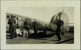
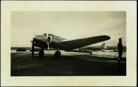
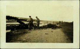
Showing 238 results

Archival description
2006.20.12.42 · Item · [ca. 1940]
Part of Northern BC Archives Historical Photograph Collection

Handwritten photo album caption below this photo reads: "The above ship, after 'doing' a barrel-roll 50 feet above the runway." Photograph depicts three men in uniform bent over wreckage of plane crash in airstrip believed to be at Whitehorse, YT. Large group of men and vehicles in background on right, trees and hillside in background on left.

Royal Canadian Air Force
2006.20.3.6 · Item · [between 29 August 1906 and 9 October 1906]
Part of Northern BC Archives Historical Photograph Collection

Photograph depicts glacier in valley below mountains. Handwritten annotation on negative: "K. Glacier [...illegible]".

Image is one of 65 photos documenting a survey of the Canada-Alaska Boundary, Taku River area, May 23 to Oct. 15, 1906.
This particular photo is one of 13 found in original enclosure with the following handwritten annotation: "Kopoka River - river scenes Aug 29 to Oct. 9 [19]06". See also items 2006.20.3.1 - 2006.20.3.13.

Taku River Survey - Campsite
2006.20.3.7 · Item · [between 29 August 1906 and 9 October 1906]
Part of Northern BC Archives Historical Photograph Collection

Photograph depicts tent among trees, hills visible in background.

Image is one of 65 photos documenting a survey of the Canada-Alaska Boundary, Taku River area, May 23 to Oct. 15, 1906.
This particular photo is one of 13 found in original enclosure with the following handwritten annotation: "Kopoka River - river scenes Aug 29 to Oct. 9 [19]06". See also items 2006.20.3.1 - 2006.20.3.13.

2006.20.3.9 · Item · [between 29 August 1906 and 9 October 1906]
Part of Northern BC Archives Historical Photograph Collection

Photograph depicts river and rocky shores, glacier visible on mountain in background. Handwritten annotation on negative: "Glacier [?] Kopoka".

Image is one of 65 photos documenting a survey of the Canada-Alaska Boundary, Taku River area, May 23 to Oct. 15, 1906.
This particular photo is one of 13 found in original enclosure with the following handwritten annotation: "Kopoka River - river scenes Aug 29 to Oct. 9 [19]06". See also items 2006.20.3.1 - 2006.20.3.13.

2006.20.3.15 · Item · [between 23 May 1906 and 15 October 1906]
Part of Northern BC Archives Historical Photograph Collection

Photograph depicts two unidentified men standing and sitting at campfire by large fallen trees. Forest and mountains in background. Handwritten annotation on negative: "[?] Taken Near Kopoka".

Image is one of 65 photos documenting a survey of the Canada-Alaska Boundary, Taku River area, May 23 to Oct. 15, 1906.
This particular photo is one of 8 found in original enclosure with the following handwritten annotation: "From main camp up Kopoka River. Scenes with persons in." See also items 2006.20.3.14 - 2006.20.3.21.

2006.20.3.20 · Item · [between 23 May 1906 and 15 October 1906]
Part of Northern BC Archives Historical Photograph Collection

Photograph depicts unknown man standing in water while pulling loaded canoe by rope. Rocky shore in foreground, mountains in background. Handwritten annotation visible on negative: "[?] hauling canoe. Big [?], Kopoka".

Image is one of 65 photos documenting a survey of the Canada-Alaska Boundary, Taku River area, May 23 to Oct. 15, 1906.
This particular photo is one of 8 found in original enclosure with the following handwritten annotation: "From main camp up Kopoka River. Scenes with persons in." See also items 2006.20.3.14 - 2006.20.3.21.

2006.20.3.21 · Item · [between 23 May 1906 and 15 October 1906]
Part of Northern BC Archives Historical Photograph Collection

Photograph depicts three unknown men standing in water while pulling loaded canoe by rope. Rocky shore and hills in background. Illegible handwritten annotation visible on negative: "...[K. River]?" (Kopoka?)

Image is one of 65 photos documenting a survey of the Canada-Alaska Boundary, Taku River area, May 23 to Oct. 15, 1906.
This particular photo is one of 8 found in original enclosure with the following handwritten annotation: "From main camp up Kopoka River. Scenes with persons in." See also items 2006.20.3.14 - 2006.20.3.20.

2006.20.3.23 · Item · [between 23 May 1906 and 15 October 1906]
Part of Northern BC Archives Historical Photograph Collection

Photograph depicts man [Gilroy?] sitting with small tin cup. Canoe lies upside down in foreground. Water and opposite shore visible in background. Handwritten annotation visible on negative: "Camp. [Gilroy?] on way up from trail. 9 pm".

Image is one of 65 photos documenting a survey of the Canada-Alaska Boundary, Taku River area, May 23 to Oct. 15, 1906.
This particular photo is one of 13 found in original enclosure with the following handwritten annotation: "SOME OTHERS." See also items 2006.20.3.22 - 2006.20.3.34.

2006.20.3.26 · Item · [between 23 May 1906 and 15 October 1906]
Part of Northern BC Archives Historical Photograph Collection

Photograph depicts two unidentified men standing to right of flag mounted in rock pile.

Image is one of 65 photos documenting a survey of the Canada-Alaska Boundary, Taku River area, May 23 to Oct. 15, 1906.
This particular photo is one of 13 found in original enclosure with the following handwritten annotation: "SOME OTHERS." See also items 2006.20.3.22 - 2006.20.3.34.

2006.20.3.32 · Item · [between 23 May 1906 and 15 October 1906]
Part of Northern BC Archives Historical Photograph Collection

Photograph depicts unknown men standing with walking sticks, carrying large bundles on their backs. Water and opposite shore in background, mountains visible in distance. Handwritten annotation visible on negative: "Billy [Gilroy?] & [?] packed for [?]".

Image is one of 65 photos documenting a survey of the Canada-Alaska Boundary, Taku River area, May 23 to Oct. 15, 1906.
This particular photo is one of 13 found in original enclosure with the following handwritten annotation: "SOME OTHERS." See also items 2006.20.3.22 - 2006.20.3.34.

2006.20.3.35 · Item · [between 23 May 1906 and 15 October 1906]
Part of Northern BC Archives Historical Photograph Collection

Photograph depicts two men standing on mountain with walking sticks, carrying bundles on their backs. Valley and mountains visible in background below. Handwritten annotation visible on negative: "[?] Climbing [?] Sta - K. River" (Kopoka?).

Image is one of 65 photos documenting a survey of the Canada-Alaska Boundary, Taku River area, May 23 to Oct. 15, 1906. This particular photo is one of 7 found in original enclosure with the following handwritten annotation: "Around River Taku and main camp on same." See also items 2006.20.3.35 - 2006.20.3.41.

2006.20.3.38 · Item · [between 23 May 1906 and 15 October 1906]
Part of Northern BC Archives Historical Photograph Collection

Icebergs can be seen in foreground, opposite shore crosses midground, mountains stand in background.

Image is one of 65 photos documenting a survey of the Canada-Alaska Boundary, Taku River area, May 23 to Oct. 15, 1906. This particular photo is one of 7 found in original enclosure with the following handwritten annotation: "Around River Taku and main camp on same." See also items 2006.20.3.35 - 2006.20.3.41.

2006.20.3.41 · Item · [between 23 May 1906 and 15 October 1906]
Part of Northern BC Archives Historical Photograph Collection

Water spans foreground, trees on shore can be seen on far left, mountains stand in background.

Image is one of 65 photos documenting a survey of the Canada-Alaska Boundary, Taku River area, May 23 to Oct. 15, 1906. This particular photo is one of 7 found in original enclosure with the following handwritten annotation: "Around River Taku and main camp on same." See also items 2006.20.3.35 - 2006.20.3.40.

2006.20.3.42 · Item · [between 23 May 1906 and 15 October 1906]
Part of Northern BC Archives Historical Photograph Collection

View of snowy mountain range.

Image is one of 65 photos documenting a survey of the Canada-Alaska Boundary, Taku River area, May 23 to Oct. 15, 1906. This particular photo is one of 5 found in original enclosure with the following handwritten annotation: "Boundary No.2 camera Sta. Twin Lake & Glacier.” See also items 2006.20.3.43 - 2006.20.3.46.

2006.20.3.43 · Item · [between 23 May 1906 and 15 October 1906]
Part of Northern BC Archives Historical Photograph Collection

Water spans foreground, cliffs cross midground, mountains stand in background.

Image is one of 65 photos documenting a survey of the Canada-Alaska Boundary, Taku River area, May 23 to Oct. 15, 1906. This particular photo is one of 5 found in original enclosure with the following handwritten annotation: "Boundary No.2 camera Sta. Twin Lake & Glacier.” See also items 2006.20.3.42 - 2006.20.3.46.

2006.20.3.48 · Item · [between 23 May 1906 and 15 October 1906]
Part of Northern BC Archives Historical Photograph Collection

Photograph depicts mountain range, river or glacier visible below.

Image is one of 65 photos documenting a survey of the Canada-Alaska Boundary, Taku River area, May 23 to Oct. 15, 1906. This particular photo is one of 10 found in original enclosure with the following handwritten annotation: "From [Wahut?]-Azmuth and Koshu.” See also items 2006.20.3.47 - 2006.20.3.56.

2006.20.3.50 · Item · [between 23 May 1906 and 15 October 1906]
Part of Northern BC Archives Historical Photograph Collection

Photograph depicts small tent set up in bushes, fallen trees in foreground.

Image is one of 65 photos documenting a survey of the Canada-Alaska Boundary, Taku River area, May 23 to Oct. 15, 1906. This particular photo is one of 10 found in original enclosure with the following handwritten annotation: "From [Wahut?]-Azmuth and Koshu.” See also items 2006.20.3.47 - 2006.20.3.56.

2006.20.3.51 · Item · [between 23 May 1906 and 15 October 1906]
Part of Northern BC Archives Historical Photograph Collection

Photograph depicts river or glacier in valley bellow mountains. Handwritten annotation visible on negative: "From No. 2 Cam. Sta. [?] Taku River [?]".

Image is one of 65 photos documenting a survey of the Canada-Alaska Boundary, Taku River area, May 23 to Oct. 15, 1906. This particular photo is one of 10 found in original enclosure with the following handwritten annotation: "From [Wahut?]-Azmuth and Koshu.” See also items 2006.20.3.47 - 2006.20.3.56.

2006.20.3.53 · Item · [between 23 May 1906 and 15 October 1906]
Part of Northern BC Archives Historical Photograph Collection

Photograph depicts river or glacier in valley bellow mountains, flat snowy area in foreground.

Image is one of 65 photos documenting a survey of the Canada-Alaska Boundary, Taku River area, May 23 to Oct. 15, 1906. This particular photo is one of 10 found in original enclosure with the following handwritten annotation: "From [Wahut?]-Azmuth and Koshu.” See also items 2006.20.3.47 - 2006.20.3.56.

2006.20.3.59 · Item · [between 23 May 1906 and 15 October 1906]
Part of Northern BC Archives Historical Photograph Collection

Photograph depicts group of six men standing and sitting in forest in front of tent structure with log base. Handwritten annotation visible on negative: "[Myself?] Main Camp".

Image is one of 65 photos documenting a survey of the Canada-Alaska Boundary, Taku River area, May 23 to Oct. 15, 1906. This particular photo is one of 9 found in original enclosure with the following handwritten annotation: "Pictures of different members of ‘our’ party.” See also items 2006.20.3.57 - 2006.20.3.65.

2006.20.9.4 · Item · November 1942
Part of Northern BC Archives Historical Photograph Collection

Photo description on accompanying photo album page: " 'Yonge Street' at Teslin Lake, Yukon. The centre tent was used by the radio men. Teslin, 130 miles south of Whitehorse, is the site of one of the aircraft radio stations on the new Edmonton-Whitehorse circuit, paralleling the Alaska Highway."

Cassiar - Stewart Highway
2006.20.9.25 · Item · [ca. 1897 - 1960]
Part of Northern BC Archives Historical Photograph Collection

View of snow capped mountains in the distance, vast rolling treed hills in mid ground and a gravel road in the foreground. Road sign indicating severe curve in road situated at the right of the gravel road. Handwritten annotation on verso in pen reads: “Cassiar – Stewart highway”

2006.20.10.14 · Item · 28 July 1901
Part of Northern BC Archives Historical Photograph Collection

Group of five miners stand in mining area on left. Woman, man, and young girl sit and stand on far right in more formal attire. Mining tools and equipment throughout.

Printed annotation on recto of photograph: "Société Minière de B.C., Atlin B.C. July 28th, 1901, A.C. Hirschfeld, No. 707".

Bridge over Dog Creek
2006.20.11.5 · Item · June 1923
Part of Northern BC Archives Historical Photograph Collection

Photograph depicts a short wooden bridge spanning Dog Creek mid-ground and a stand of trees in the background. There are many Dog Creeks within British Columbia, it is believed this Dog Creek is located just south of Fort St. James, BC. Handwritten photo caption below photograph reads: "Dog Creek".

Pack Dogs at Fort St. James
2006.20.11.7 · Item · June 1923
Part of Northern BC Archives Historical Photograph Collection

Photograph depicts two First Nations men and two pack dogs loaded with bags. A small group of people can be seen in distance in front of semi-visible building. Stand of trees in background. Handwritten photo caption below photograph reads: "Indians & Pack Dogs - Fort St. James."

Train at Endako
2006.20.11.13 · Item · June 1923
Part of Northern BC Archives Historical Photograph Collection

Photograph depicts two men standing at tracks in front train engine. The number "615" is displayed on train. Trees and hills can be seen in background as well as a semi-visible group of buildings. Handwritten photo caption below photograph reads: "Canadian National Rlys Endako, BC."

2006.20.11.18 · Item · June 1923
Part of Northern BC Archives Historical Photograph Collection

Photograph depicts a glassy body of water with trees on opposite bank crossing mid ground. Mountains visible in distant background. A clear reflection of the trees and mountains is mirrored in the water. Handwritten photo caption below photograph reads: "The Whistlers across Lake Beau Vert (7. AM.)"

Pearl Street in Atlin, BC
2006.20.11.22 · Item · August 1899
Part of Northern BC Archives Historical Photograph Collection

Photograph depicts buildings and signage on either side of dirt road. Unidentified man stands on far left, Atlin Lake and mountains can be seen in background.

Hand inscribed annotation on recto of photograph reads: “Pearl St., Atlin, B.C. Aug. 1899. A.C. Hirschfeld, No.74”.

Pearl Avenue in Atlin, BC
2006.20.11.23 · Item · [ca. 1899]
Part of Northern BC Archives Historical Photograph Collection

Photograph depicts tent buildings on either side of dirt road. Unidentified men are visible on left, Atlin Lake and mountains can be seen in background.

Hand inscribed annotation on recto of photograph reads: “Pearl Av. looking towards Atlin Lake, Atlin, B.C., A.C. Hirschfeld, No. 174”

Loading for the North
2006.20.12.3 · Item · [ca. 1940]
Part of Northern BC Archives Historical Photograph Collection

Photograph depicts five men in uniform loading supplies onto a military plane with the number "7632" on its side. Handwritten photo album caption below this photo reads: "LOADING FOR THE NORTH." It is believed this photograph was taken at the military base in Whitehorse, YT.

Royal Canadian Air Force
2006.20.12.4 · Item · [ca. 1940]
Part of Northern BC Archives Historical Photograph Collection

Photograph depicts two men (one in uniform) standing in an airstrip under the nose of a military plane with the number "7632" on its side. A third man stands in uniform on far right, and a building can be seen in distance behind him on the flat horizon. Handwritten photo album caption below this photo reads: "MAJESTIC '32'." It is believed this photograph was taken at the military base in Whitehorse, YT.

Royal Canadian Air Force