Affichage de 3025 résultats

Archival description
3025 résultats avec objets numériques Afficher les résultats avec des objets numériques
Canoe Creek
2012.13.1.52.58 · Pièce · [1980?]
Fait partie de J. Kent Sedgwick fonds

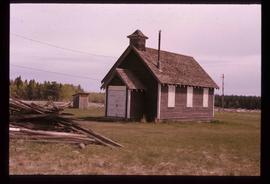
Image depicts a church and several other buildings in Canoe Creek.

Spring House
2012.13.1.52.61 · Pièce · [1980?]
Fait partie de J. Kent Sedgwick fonds

Image depicts an old building at an uncertain location. The slide is simply labelled "Spring house."

Fraser River
2012.13.1.53.06 · Pièce · June 1974
Fait partie de J. Kent Sedgwick fonds

Image depicts a view of the Fraser River near Lillooet, B.C.

Moran Canyon
2012.13.1.53.23 · Pièce · Mar. 1975
Fait partie de J. Kent Sedgwick fonds

Image depicts the Fraser River running through the Moran Canyon near Lillooet, B.C.

Moran Canyon
2012.13.1.53.48 · Pièce · July 1982
Fait partie de J. Kent Sedgwick fonds

Image depicts a view of Moran Canyon in the Lillooet area. The Fraser River is visible on the left.

Howe Sound - Squamish (Stawamus) Chief
2012.13.1.54.33 · Pièce · July 1977
Fait partie de J. Kent Sedgwick fonds

Image depicts a view of Howe Sound from the Stawamus Chief Nature Trail to the Stawamus Chief Mountain, which is often incorrectly referred to as "Squamish" Chief.

Nairn Falls
2012.13.1.54.39 · Pièce · July 1977
Fait partie de J. Kent Sedgwick fonds

Image depicts the Nairn Falls in Nairn Falls Provincial Park south of Pemberton, B.C.

Nairn Falls
2012.13.1.54.41 · Pièce · July 1977
Fait partie de J. Kent Sedgwick fonds

Image depicts the Nairn Falls in Nairn Falls Provincial Park south of Pemberton, B.C.

Britannia Mine Entrance?
2012.13.1.54.52 · Pièce · July 1980
Fait partie de J. Kent Sedgwick fonds

Image depicts the entrance to a mine with an unknown individual present. It is possibly the entrance to the closed Britannia Mine in the Howe Sound Region.

Slough - Canoeing
2012.13.1.55.35 · Pièce · 1971
Fait partie de J. Kent Sedgwick fonds

Image depicts a few unknown individuals canoeing in a slough area while on approach to Bowron Lake.

Slough
2012.13.1.55.37 · Pièce · 1971
Fait partie de J. Kent Sedgwick fonds

Image depicts a slough area while on approach to Bowron Lake.

Two Men
2012.13.1.56.03 · Pièce · 1973
Fait partie de J. Kent Sedgwick fonds

Image depicts two men on the hiking trail near Mt. Robson.

Felled Trees
2012.13.1.56.06 · Pièce · 1973
Fait partie de J. Kent Sedgwick fonds

Image depicts a large number of felled trees, and an unknown individual standing on the path.

Waterfall
2012.13.1.56.12 · Pièce · 1973
Fait partie de J. Kent Sedgwick fonds

Image depicts a waterfall on a mountain side in Mt. Robson Provincial Park.