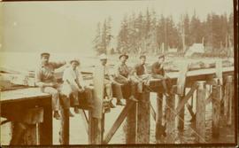
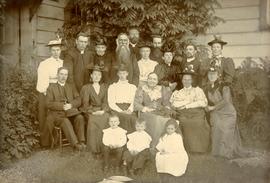
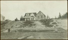
Members of the Collison family casually fishing from a large dock. Handwritten annotation on verso reads: "Collison family fishing from dock (Portland[?] Canal) {Max Elsie Henry Will Arthur Herbert}."
Large crowd gathered on the street in downtown Prince Rupert around a lavishly decorated arch which reads "Come One Let 'Em All Come Come All. Welcome to Prince Rupert." Annotation on recto reads: "Arch Prince Rupert, BC. Dominion Day Celebration 1909. Allen Photo."
Photograph of several floats parading down Second Avenue in Prince Rupert. A large crowd is gathered. Annotation on recto reads: "Photo by MacRae Bros Prince Rupert BC Prince Rupert B."
Photograph depicts Marion and William Henry Collison standing on left with shovel, Bertha Collison on right, and young Muriel and Katherine Collison in centre with shovel (eldest daughters of W.E. Collison). Wood buildings cross midground, trees and hills visible in background.
Handwritten annotation on verso reads: "Garden at Kincolith / Grandad, Grannie / Mimi, Katie / Mother".
Group of men, women, and children pose in front of large building.
Handwritten annotation on verso reads: "Metlakatla BC / with Bishop Ridley - 4th from left - back row / Mrs Ridley - 4th from left - front row / [?] - [super?] of Ridley Home (beside the Bishop) / Father Hogan - behind the Bishop".
Large church stands behind white fence, unidentified man visible on front steps. Photograph depicts the first church built in Metlakatla, which was burned in a fire in 1901, and replaced in 1903.
Handwritten annotation on verso reads: "With love, from your two old friends JH [& AM Keen?]".
Banner at front of sanctuary reads "Do this in remembrance of Me".
Handwritten annotation on verso reads: "Interior of old church. Built by natives themselves".
Groups of men and women can be seen gathered on paths between two large totem poles.
Handwritten annotation on verso reads: "Totem Park Pr Rupert park."
Photograph depicts large buildings on shore. Three unidentified individuals can be seen walking on dock in foreground.
Printed on image: "METLAKATLA B.C. / McRAE BROS"; handwritten annotation on verso reads: "A section of Metlakahtla, showing Church & Schoolhouse." See also item 2009.7.1.58 for similar image also featuring the new church building at Metlakatla, B.C.
Photograph depicts fenced area in front of church building with turret. Other community buildings can be seen in background.
Handwritten annotation on verso reads: "Metlakatla Church. Replacement for larger church lost in village fire 1903?" See also item 2009.7.1.55 for similar image depicting new church building at Metlakatla, B.C.
Photograph depicts an unidentified man walking on path in front of Bishop Ridley's home. Several children can be seen in fenced yard in midground.
Handwritten annotation below image reads: "Ridley Home and Mission house Metlakahtla."; on verso: "Chapter XXVII / Heading for Chapter / Ridley Home Metlakahtla".
Photograph depicts a man and woman standing on steps to a round tower in fenced area. Roofs of other buildings can be seen below on right; water and shore visible in background.
Printed on image: "Indian Jail, Metlatkla".
Photograph has been altered with drawings of people on shore fighting canoes approaching the town. Buildings stand behind fenced and walled areas in background.
Handwritten annotation below image reads: "Drawing by F.A., old Hudson B. [...?]"; on verso: "27. To head Chapter III. No. 2. Tsimshians and Haidas fighting on shore at Fort Simpson."
Large bear carving sits on top of wide pole, erected in memory of a chief of the Bear crest. Lines of houses stand in background.
Printed below image: "Totem Pole. Old Massett. Q.C.I / J.D. Allen photo Co."; handwritten below: "Mortuary Pole Bear [Crest?]"; on verso: "For Chapt. XIX. The old style and the new. Mortuary Pole & modern houses. No. 3. W.H.C. Oct. [6/ ?] 13".
Photograph depicts village buildings along shore.
Handwritten annotation on verso reads: "Massett in Winter dress."
Photographs depict large building in fenced area, trees in yard and in background.
Handwritten annotations on verso read: "Mission House at Massett QCIs"; "Mission House at Massett - Mother & Dad lived there."
Group of eight men wearing suits and ties pose with Reverend Collison (oldest son of Marion & Archdeacon W.H. Collison).
Handwritten annotation on verso reads: “Rev. W. E. Collison & his Lay Readers at Massett, Q.C.Is.”
Photograph depicts an unidentified individual leaning against a large overturned dugout canoe; barrel, bucket, and wood planks in foreground. Houses and other buildings can be seen on shore above beach, and two unidentified individuals stand in distance on far right.
Handwritten annotations on verso read: “Haida canoe on beach at Masset / ? 1898”; “No. 4 Page 5. Haida Canoe ready for steaming to [widen?] out and finish.”
An original negative of this photograph is held by the Canadian Museum of Civilization, no. 26664.
Chief Allen sits in chair on raised wooden platform, with bear skin over his knee, and two more bear skins laid on wood blocks in front of him. House stands behind picket fence in background. Pot and pan sit to right of chair in foreground.
Handwritten annotation on verso reads: "Albert Allen Kincolith (Nisga Chief)".
Arthur Collison stands behind large fish hung from wood shelter, Noah seated in foreground. Arthur is the youngest son of Marion and Archdeacon W.H. Collison.
Handwritten annotation on verso reads: "Arthur Collison with our friend 'Noah' with catch - at Kincolith Nass River".
Photograph depicts large church building behind white fence. Other buildings visible in background.
Handwritten annotation on verso reads: "New Church Kincolith Nass River BC".
Photograph depicts an empty canoe floating beside a canoe full of fish. Hills visible on opposite shore in distance.
Handwritten annotation on verso reads: "Loaded with fish - Nass River".
Group of six men sit and stand on small boat close to shore. Rev. W.E. Collison stands on far right (son of Marion and Archdeacon W.H. Collison).
Handwritten annotation on verso reads: "Dr. Macdonald Med officer (Kincolith) / Dr. [McQuarrie?] Med officer Victoria / Steven Clayton Native boat owner / Capt. Bary - Insp. of Indian Schools / W.E. Collison Indian agent. / Inspection trip to villages of upper Nass River".
Shoreline perspective of an unidentified coastal village situated on B.C.’s north coast. European style houses run parallel to a rocky shore. Seven men and one child stand within this frame and totem poles and a mortuary pole are also visible along the shoreline.
Seven young boys enjoying a game of tug-a-war alongside a wooden track. Track runs along a picket fence through a village. A small girl watches the fun from the sidelines and older woman carries a basket in the background. Handwritten annotation in pen on verso reads: “Native children at play”.
Image depicts Highway 97 at 15th Ave. looking north. Map coordinates 53°54'42.1"N 122°46'53.1"W
Image depicts a marching band with numerous other unidentified individuals. One man is carrying a Canadian flag with the depiction of men in a boat and the words "Canada Sea-to-Sea" on it.
Image depicts a marching band with numerous other unidentified individuals. One man is carrying a Canadian flag with the depiction of men in a boat and the words "Canada Sea-to-Sea" on it, and there is a mascot beside him that appears to be a chipmunk in an RCMP uniform.
Image depicts a marching band with numerous other unidentified individuals. One man is carrying a Canadian flag with the depiction of men in a boat and the words "Canada Sea-to-Sea" on it.
Image depicts a group of individuals standing on the corner of 3rd Ave in Prince George, B.C.
Item is a hand drawn and coloured map by the City of Prince George Planning Department depicting North Nechako neighbourhood area existing land use in 1976.
Item is a hand drawn and coloured map by the City of Prince George Planning Department depicting the College Heights and southwest (Vanway) neighbourhood area existing land use in 1976.
Item is a map depicting a future low density development plan for the Peden Hill neighbourhood in Prince George.
Item is a map depicting a future high density development plan for the Peden Hill neighbourhood in Prince George.
Item is a map depicting the areas of winter shadow in the Peden Hill neighbourhood in Prince George.
Item is Map 1 of a group of five maps relating to a City of Prince George Study of Construction Aggregates by the firm Willis, Cunliffe, Tair & Company Limited. Map 1 shows development areas and population for 1984 and 1994. As the map is undated, it is unclear whether the 1984 and 1994 dates are future estimates.
Item is Map 4 of a group of five maps relating to a City of Prince George Study of Construction Aggregates by the firm Willis, Cunliffe, Tair & Company Limited. Map 4 shows development areas, aggregate sources, and requirements for 1984 and 1994. As the map is undated, it is unclear whether the 1984 and 1994 dates are future estimates.
This map is part of Schedule B of the 1993 Official Community Plan, Bylaw No. 5909 for the City of Prince George. This particular map reflects the 1998 amendment to the Official Community Plan.
This map depicts the City of Prince George's plan for soil removal and deposit.
This map is part of Schedule B of the 1993 Official Community Plan, Bylaw No. 5909 for the City of Prince George. This particular map reflects the 1998 amendment to the Official Community Plan.
This map is the May 2008 amendment (Bylaw 8061) of the Schedule C of the 2001 Official Community Plan, Bylaw No. 7281 for the City of Prince George. This Schedule C map shows the long range land use for the City of Prince George.