Affichage de 54061 résultats

Archival description
21791 résultats avec objets numériques Afficher les résultats avec des objets numériques
Eagles in Kaleden, BC
2020.4.8.1.0017 · Pièce · May 1968
Fait partie de G. Gary Runka fonds

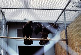
Slide depicts two eagles in an enclosure. The photograph was taken in Kaleden, BC. Original slide index description: "Eagles, Kaleden."

Camel in Kaleden, BC
2020.4.8.1.0016 · Pièce · May 1968
Fait partie de G. Gary Runka fonds

Slide depicts a close up of a camel behind a fence. The photograph was taken in Kaleden, BC. Original slide index description: "Camel, Kaleden."

Camel and llamas in Kaleden, BC
2020.4.8.1.0015 · Pièce · May 1968
Fait partie de G. Gary Runka fonds

Slide depicts a camel and two llamas in an enclosed pasture. The photograph was taken in Kaleden, BC. Original slide index description: "Camel & Llamas in pasture, Kaleden."

Peach blossoms in Casa Loma
2020.4.8.1.0014 · Pièce · May 1968
Fait partie de G. Gary Runka fonds

Slide depicts peach trees blossoming in an orchard. Original slide index description: "Peach blossoms Casa Loma."

Apple blossom in Kelowna
2020.4.8.1.0013 · Pièce · May 1968
Fait partie de G. Gary Runka fonds

Slide depicts an apple tree blossoming in a backyard. The yard is surrounded by a wooden fence. Original slide index description: "Apple blossoms Kelowna."

Peach blossoms in Shanboolard
2020.4.8.1.0010 · Pièce · May 1968
Fait partie de G. Gary Runka fonds

Slide depicts peach trees blossoming in an orchard. Original slide index description: "Peach blossoms Shanboolard."

Peach blossoms in Shanboolard
2020.4.8.1.0009 · Pièce · May 1968
Fait partie de G. Gary Runka fonds

Slide depicts a close up of peach blossoms on a branch. Original slide index description: "Peach blossoms Shanboolard."

Cherry blossoms
2020.4.8.1.0008 · Pièce · May 1968
Fait partie de G. Gary Runka fonds

Slide depicts a close up of cherry blossoms on a branch. Original slide index description: "Cherry blossoms Kel."

Peach blossoms in Casa Loma
2020.4.8.1.0007 · Pièce · May 1968
Fait partie de G. Gary Runka fonds

Slide depicts a close up of two peach trees blossoming in someone's yard. Original slide index description: "Close up of Peach Blossoms, Casa Loma."

Tulips and cherry blossom trees
2020.4.8.1.0006 · Pièce · May 1968
Fait partie de G. Gary Runka fonds

Slide depicts a row of red and yellow tulips in front of a row of blossoming cherry trees. Original slide index description: "Tulips & Chery Blossoms Ok. Mission."

Mount Boucherie orchards
2020.4.8.1.0005 · Pièce · May 1968
Fait partie de G. Gary Runka fonds

Slide depicts orchards surrounding Mount Boucherie. The Okanagan Lake and mountains can be seen in the background. Original slide index description: "Orchards & sunflowers from Mt. Boucherie."

Kelowna park entrance
2020.4.8.1.0004 · Pièce · May 1968
Fait partie de G. Gary Runka fonds

Slide depicts the park entranceway to Kelowna on the East side of the Okanagan Lake Bridge. Original slide index description: "Park entrance to Kelowna."

Mission Flats
2020.4.8.1.0003 · Pièce · May 1968
Fait partie de G. Gary Runka fonds

Slide depicts Mission Flats from South East Kelowna. Photograph taken from an empty field and depicts a developed field and a wooden house. Mountains and the Okanagan Lake can be seen in the background. Original slide index description: "Mission Flats from SE Kel."

Kelowna and Casa Loma
2020.4.8.1.0002 · Pièce · May 1968
Fait partie de G. Gary Runka fonds

Slide depicts Kelowna and Casa Loma photographed during the day from across the Okanagan Lake in the Lakeview Heights area. Original slide index description: "Kel & Casa Loma from Lakeview Hts."

Apple blossom in Kelowna
2020.4.8.1.0001 · Pièce · May 1968
Fait partie de G. Gary Runka fonds

Slide depicts a tree with apple blossoms in a backyard of a brown house. The yard is surrounded by a wooden fence. The neighbor's white house can be seen next door. Photographed in Kelowna, BC. Original slide description: "Apple Blossom bkyd. Kel."

Maps
2012.13.6 · Série organique · 1917-2003
Fait partie de J. Kent Sedgwick fonds

Series consists of maps collected by Kent Sedgwick covering historical and contemporary British Columbia. The maps include originals and photocopies that depict Fort George; Indian Reserve No.1; Anahim Lake, Bella Colla, Quesnel; Salmon Valley; the Cariboo district; the Peace River Country; Prince Rupert; Terrace; Bowron River; Giscome; Prince George; and Isle Pierre. The maps include tourism and recreation maps, pre-emptor maps, and resource maps created by the Province of British Columbia.

"Prince George B.C."
2012.13.2.21.08.1 · Pièce · 26 Apr. 1967
Fait partie de J. Kent Sedgwick fonds

This very large drawing shows CN leases and private property buildings on Island Cache in detail.

Sans titre
Cottonwood Island maps and plans
2012.13.2.21.08 · Dossier · [between 1972 and 1979]
Fait partie de J. Kent Sedgwick fonds

File consists of maps and plans depicting the Cottonwood Island area in Prince George. Includes:

  • "Plan of Subdivision pursuant to the replotting provisions of the Municipal Act of Parcel A of Plan 25046, of District Lots 343, 662, 1511, 4736, and 7813, Cariboo District" by McWilliam, Whyte, Goble & Associates B.C. Land Surveyors for the City of Prince George, 26 July 1979 (reproduction on 2 sheets)
  • "Cottonwood Island" original draft map with annotations by Kent Sedgwick; the map may have been created by Sedgwick during his time as Senior City Planner with the City of Prince George [197-?]
  • "Prince George B.C., Fraser Subdivision, Mile 146.05" plan for Canadian National Railways by Lockwood Survey Corporation Ltd., 1967. This very large technical drawing shows CN leases and private property buildings on Island Cache in detail.
  • McWilliam-Whyte-Goble & Associates, B.C. Land Surveyors, "Plan Showing Sections in Proposed Lakeland Mill Site", July 1978 (original reproduction).
  • Carroll, Hatch & Associates, "Lakeland Mills (1973) Ltd., Prince George, B.C., Stud Mill Studies, Site Plan", 31 July 1978 (original reproduction).
2012.13.2.21.06 · Dossier · 1973-1980
Fait partie de J. Kent Sedgwick fonds

File consists of records created and collected by Kent Sedgwick regarding Cottonwood Island in connection with his employment with the City of Prince George Planning Department. Includes briefs, proposals, memoranda, correspondence, newspaper clippings, questionnaires, legal correspondence, meeting minutes, and photocopied excerpts from maps/plans. Also includes two polaroid photo prints depicting garbage in Cottonwood Island Park circa 1979. Highlights include:

  • Prince George Kiwanis Club, "Brief to City Council, City of Prince George, re: Nechako Riverfront Park", 12 Mar. 1973.
  • New Caledonia Institute of Environmental Studies, "Proposal for Cottonwood Island as a Park Reserve", Summer 1973.
  • "Cottonwood Island Study", [before 1975] (photocopy).
  • Mary Fallis, "Letter to the Editor of The Citizen", 5 Mar. 1976 (photocopy).
  • City of Prince George Planning Department, "Ownership, Legal and Assessment Data - Private and School District Properties within the Proposed Replot Area [Island Cache]", 11 Oct. 1978.
  • "Assessed Values for City and Crown Lands within the Proposed Replot Area North of First Ave" (handwritten table), 16 Oct. 1978.
Fort George Canyon
2012.13.2.03.05.54 · Pièce · 1986
Fait partie de J. Kent Sedgwick fonds

The item is a photograph depicting the Fraser River running through Fort George Canyon.

Fort George Canyon
2012.13.2.03.05.53 · Pièce · 1986
Fait partie de J. Kent Sedgwick fonds

The item is a photograph depicting the Fraser River running through Fort George Canyon.

Barn at Holzworth homestead
2012.13.2.03.05.52 · Pièce · 1986
Fait partie de J. Kent Sedgwick fonds

The item is a photograph depicting an old, abandoned wooden barn on the Holzworth homestead in the Fort George Canyon.

Fort George Canyon
2012.13.2.03.05.49 · Pièce · 1986
Fait partie de J. Kent Sedgwick fonds

The item is a photograph depicting the Fraser River running through the Fort George Canyon.

Fort George Canyon
2012.13.2.03.05.48 · Pièce · 1986
Fait partie de J. Kent Sedgwick fonds

The item is a photograph depicting the Fraser River running through the Fort George Canyon.

Kent Sedgwick in Fort George Canyon
2012.13.2.03.05.47 · Pièce · 1986
Fait partie de J. Kent Sedgwick fonds

The item is a photograph depicting Kent Sedgwick sitting at the edge of the Fraser River running through the Fort George Canyon. Sedgwick is sitting on the riverside smoking a pipe.

Kent Sedgwick in Fort George Canyon
2012.13.2.03.05.46 · Pièce · 1986
Fait partie de J. Kent Sedgwick fonds

The item is a photograph depicting Kent Sedgwick sitting at the edge of the Fraser River running through the Fort George Canyon. Sedgwick is sitting on a large rock smoking a pipe next to a dog.

Fort George Canyon
2012.13.2.03.05.45 · Pièce · 1986
Fait partie de J. Kent Sedgwick fonds

The item is a photograph depicting the Fraser River running through the Fort George Canyon.

Fort George Canyon
2012.13.2.03.05.44 · Pièce · 1986
Fait partie de J. Kent Sedgwick fonds

The item is a photograph depicting the Fraser River running through the Fort George Canyon.

Fort George Canyon
2012.13.2.03.05.43 · Pièce · 1986
Fait partie de J. Kent Sedgwick fonds

The item is a photograph depicting the Fraser River running through the Fort George Canyon.

Fort George Canyon
2012.13.2.03.05.42 · Pièce · 1986
Fait partie de J. Kent Sedgwick fonds

The item is a photograph depicting the Fraser River running through the Fort George Canyon.

Fort George Canyon
2012.13.2.03.05.41 · Pièce · 1986
Fait partie de J. Kent Sedgwick fonds

The item is a photograph depicting the Fraser River running through the Fort George Canyon.

Fort George Canyon
2012.13.2.03.05.40 · Pièce · 1986
Fait partie de J. Kent Sedgwick fonds

The item is a photograph depicting the Fraser River running through the Fort George Canyon.

Fort George Canyon
2012.13.2.03.05.39 · Pièce · 1986
Fait partie de J. Kent Sedgwick fonds

The item is a photograph depicting the Fraser River running through the Fort George Canyon.

Fort George Canyon
2012.13.2.03.05.38 · Pièce · 1986
Fait partie de J. Kent Sedgwick fonds

The item is a photograph depicting the Fraser River running through the Fort George Canyon.

Fort George Canyon
2012.13.2.03.05.36 · Pièce · 1986
Fait partie de J. Kent Sedgwick fonds

The item is a photograph depicting the Fraser River running through the Fort George Canyon.

Fort George Canyon
2012.13.2.03.05.37 · Pièce · 1986
Fait partie de J. Kent Sedgwick fonds

The item is a photograph depicting the Fraser River running through the Fort George Canyon.

Fort George Canyon
2012.13.2.03.05.35 · Pièce · 1986
Fait partie de J. Kent Sedgwick fonds

The item is a photograph depicting the Fraser River running through the Fort George Canyon.

Fort George Canyon
2012.13.2.03.05.34 · Pièce · 1986
Fait partie de J. Kent Sedgwick fonds

The item is a photograph depicting the Fraser River running through the Fort George Canyon.

Fort George Canyon
2012.13.2.03.05.33 · Pièce · 1986
Fait partie de J. Kent Sedgwick fonds

The item is a photograph depicting the Fraser River running through the Fort George Canyon.

Fort George Canyon
2012.13.2.03.05.32 · Pièce · 1986
Fait partie de J. Kent Sedgwick fonds

The item is a photograph depicting the Fraser River running through the Fort George Canyon.

Fort George Canyon
2012.13.2.03.05.31 · Pièce · 1986
Fait partie de J. Kent Sedgwick fonds

The item is a photograph depicting the Fraser River running through the Fort George Canyon.