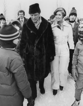
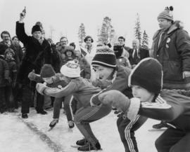
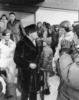
Photograph depicts Iona Campagnolo standing on ice with Pierre Trudeau at a children's speed skating event during the 1978 Northern BC winter games. Several unidentified children and adults surround them.
Photograph depicts Pierre Trudeau firing a starting pistol at a children's speed skating event during the 1978 Northern BC Winter Games. Iona Campagnolo, Ron Bassford and an unidentified crowd watch four children crouch at the starting line.
Photograph depicts Pierre Trudeau talking with a crowd of children and adults at a children's speed skating event during the 1978 Northern BC Winter Games. Iona Campagnolo stands behind Pierre Trudeau, looking downward. Two photographers are in the foreground.
Photograph depicts Pierre Trudeau talking with a four unidentified children at a children's speed skating event during the 1978 Northern BC Winter Games. Iona Campagnolo stands behind Pierre Trudeau. An unidentified man is in the foreground. Several unidentified adults are in the background.
Photograph depicts Prime Minister Pierre Trudeau and three women in a crowd at a Northern BC Winter Games event in Prince George.
Image depicts a view of Prince George from City Hall looking northeast with the pulp mills in the background. Map coordinates 53°54'46.3"N 122°44'41.9"W
Image depicts a view of Prince George from Cranbrook Hill looking southeast. Map coordinates 53°54'51.5"N 122°49'05.2"W
Map depicts the city of Prince George Boundary expansions since incorporation in 1915.
Item consists of transcript of taped interview with Prince George Fire Chief Harold Dornbierer conducted by Bob Harkins at Prince George Radio Station, CJCI regarding his career in fire protection. Dornbierer also discusses history of of the fire department of Prince George.
Zonder titelItem consists of transcript and tape summary of interview with Tom Waller who discusses fire protection and forest fires in the Prince George and Peace River region.
Zonder titelItem consists of transcript and tape summary of recording and speeches during the Freeman Banquet honouring Harold Moffat, Mayor of Prince George on his retirement as mayor.
Zonder titelItem consists of transcript of interviews with guests on the Simon Break radio show including members of the musical group The Rhythm Pals and librarian Anne Allgaier.
Zonder titelImage depicts a view of the landscape surrounding Tabor Mountain in Prince George, B.C.
Image depicts Brunswick Street at 3rd Ave in -35 degree weather. Map coordinates 53°55'03.0"N 122°44'51.7"W
Image depicts the Central Business District of Prince George looking north from Connaught Hill. Map coordinates 53°54'41.4"N 122°44'58.5"W
Image depicts a view of Prince George from Gunn Point in the L.C. Gunn Park looking north. Map coordinates 53°54'26.2"N 122°43'35.8"W.
Image depicts the Columbus Hotel in Prince George, which was destroyed by a fire in 2008.
Image depicts the Canadian Forces Recruiting Centre on the north side of 3rd Ave in Prince George, B.C.
File contains slides depicting schools in Prince George, B.C.
Image depicts trains at the Grand Trunk Pacific railway roundhouse in Prince George, B.C.
Image depicts the Grand Trunk Pacific railway roundhouse in Prince George, B.C.
Image depicts the interior of the GTP roundhouse in Prince George, B.C.
Item consists of printed transcript and tape summary of interview with Tony and Alma Skae who discuss their family's history in Stone Creek and later Prince George particularly in the newspaper and food and hospitality industry
Zonder titelItem consists of transcript and tape summary of interview with Tom Payne who discusses his life, emigration from England, service in World War I, and career as shoemaker in Quesnel. Also discusses his subsequent work at the Experimental Farm in Prince George
Zonder titelItem consists of transcript of interview with musician Gary Fjellgaard
Zonder titelSubseries contains material collected and created by Kent Sedgwick for research regarding various areas surrounding Prince George. Includes materials on the Crooked River area; Summit Lake; Ferguson Lake; Chief Lake; Salmon Valley; Mud River; Beaverly; Buckwater; Chilako River; Indian Reserve no. 4; Blackburn; Pineview; Stone Creek; Red Rock; Woodpecker; and Hixon. The files primarily consist of research notes and photographs depicting the communities.
Image depicts logs being stripped of their bark at a saw mill in Prince George, B.C.
Image depicts a view of Prince George from Gunn Point in the L.C. Gunn Park looking north. Map coordinates 53°54'26.2"N 122°43'35.8"W.
Image depicts the south side of 3rd Ave in Prince George, B.C.
Image depicts the Europe Hotel on the south side of 3rd Ave in Prince George, B.C.
File contains slides depicting images of the Grand Trunk Pacific railway roundhouse in Prince George, B.C.
Image depicts what is possibly a train fuelling station at the GTP Roundhouse in Prince George, B.C.
Image depicts the Grand Trunk Pacific railway roundhouse in Prince George, B.C.
Image depicts machinery in the GTP roundhouse in Prince George, B.C.
Image depicts the GTP roundhouse in Prince George, B.C.
Image depicts a train in the interior of the GTP roundhouse in Prince George, B.C.
Image depicts the interior of the GTP roundhouse in Prince George, B.C.
Image depicts an old, boarded up school, possibly the Central Fort George Traditional School in Prince George, B.C.
Item is a map depicting proposed land use between 1978 and 2012 in the City of Prince George. This map was drawn for the City of Prince George Community Plan; this particular version of the map was displayed in City of Prince George council chambers through 1979.
Image depicts 3rd Ave at Brunswick Street in -35 degree weather. Map coordinates 53°55'03.0"N 122°44'51.7"W
Image depicts a view of Prince George from Gunn Point in the L.C. Gunn Park looking north. Map coordinates 53°54'26.2"N 122°43'35.8"W.
Image depicts the north side of 3rd Ave in Prince George, B.C.
Image depicts a tractor with a claw lifting logs at a saw mill in Prince George, B.C.
Image depicts numerous logs that have been stripped of their bark at a saw mill in Prince George, B.C.
Image depicts what is possibly a train fueling station at the GTP Roundhouse in Prince George, B.C.
Image depicts a train in the GTP roundhouse in Prince George, B.C.