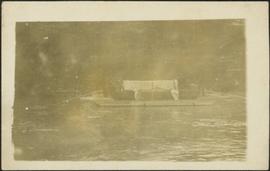
Showing 4832 results

Archival description
4073 results with digital objects Show results with digital objects
2009.5.3.43 · Item · [ca. 1913]
Part of Taylor-Baxter Family Photograph Collection

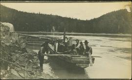
Photograph depicts group of men seated on scow carrying unidentified material. One man stands on rocky shore in left foreground, leaning on plank attached to scow. A second scow can be seen behind men. Tree-covered hills on opposite shore in background.

Bourchier Supply Camp
2009.5.3.35 · Item · [ca. 1913]
Part of Taylor-Baxter Family Photograph Collection

Photograph depicts men standing on shore in front of tents, forest trees in background. Photograph was taken from a boat; portion of boat and oar are visible in foreground. Handwritten annotation on recto of photograph: "View of all four tents."

2013.6.36.1.069.24 · Item · [July 1973]
Part of David Davies Railway Collection

Photo depiicts a bridge over the Fraser River, south of Williams Lake. It was in poor condition, but was being prepared by the Department of Highways. The bridge was taken on the Gang Ranch public road, and led to the ranch and its uninhabited hinterland.

2013.6.36.1.069.18 · Item · [9 July 1980]
Part of David Davies Railway Collection

Photograph taken on Highway 16, between Vanderhoof and Burns Lake. This road and bridge was to be passed by a new section of the highway. To the date the photograph was taken, all traffic between Prince George and Prince Rupert had used the bridge.

Bridge Crossing River Canyon
2009.5.1.72 · Item · [ca. 1900]
Part of Taylor-Baxter Family Photograph Collection

Photograph depicts bridge built with wooden planks and poles, with triangles built into its frame. Water rapids in foreground, opposite shore in background behind bridge. This is speculated to be one of the bridges that crossed the Hagwilget Canyon on the Bulkey River since 1859, five kilometres from its confluence with the Skeena River. See items 2009.5.1.69 - 2009.5.1.71.

2013.6.36.1.027.02 · Item · [23 June 1979]
Part of David Davies Railway Collection

Photograph depicts bridge #504 crossing Wilkinson Creek at the top end of the Sawyer loop. This is at about mile 50.75 on the CPR line in the Carmi Subdivision. The elevation here is 2973 ft. and the line is climbing at an even ascent. The view is looking northeast.

Bridge over Dog Creek
2006.20.11.5 · Item · June 1923
Part of Northern BC Archives Historical Photograph Collection

Photograph depicts a short wooden bridge spanning Dog Creek mid-ground and a stand of trees in the background. There are many Dog Creeks within British Columbia, it is believed this Dog Creek is located just south of Fort St. James, BC. Handwritten photo caption below photograph reads: "Dog Creek".

Bridge over Lardeau River
2013.6.36.1.069.14 · Item · 10 Sept. 1970
Part of David Davies Railway Collection

Photograph depicts a bridge over Lardeau River. Survey stakes at the point where the photograph was taken suggested that a new bridge would be built within the next 2 or 3 years.

Bridge over Portage River
2013.6.36.1.069.09 · Item · Aug. 1969
Part of David Davies Railway Collection

Photograph depicts a bridge near the beginning of the Seton Portage to D'Arcy dirt road over the Portage River. The road was a one and half of a mile connection between the Anderson (upper) and Seton (lower) lakes.

Bridge over Powell Lake
2013.6.36.1.001.86 · Item · Apr. 1966
Part of David Davies Railway Collection

Photograph depicts a bridge over Powell Lake, directly behind Powell River town. The bridge is in poor condition and being replaced by steel bridge at right (just off the picture).

2013.6.36.1.001.90 · Item · [May 1966]
Part of David Davies Railway Collection

Photograph depicts the bridge over the south Thompson River at Squilax where the road connects Squilax Village with a First Nations reservation on the north bank (photo background). The overhead truss in the center span was created to give clearance to paddle sternwheelers.

2013.6.36.1.001.84 · Item · Oct. 1965
Part of David Davies Railway Collection

Photograph depicts the bridge over the north Thompson River at Barriere, 40 miles north of Kamloops. View is looking towards the east bank. A new bridge is being built half a mile upstream and just awaiting decking.

Bridges
2013.6.36.1.001 · File · 1964-1966
Part of David Davies Railway Collection

File consists of documentary photographs taken by David Davies of bridges in British Columbia.

2013.6.36.1.054.24 · Item · 30 Sept. 1975
Part of David Davies Railway Collection

Photograph depicts a concentrator mill. The mine was closed for good on November 1, 1974. An auction of all residual equipment took place in August 1975. B.C. Museum of Mining is located mid-right of the photo.

2013.6.36.1.054.37 · Item · 30 Sept. 1975
Part of David Davies Railway Collection

Photograph depicts the general view of the yards of the Anaconda Britannia Mine. Visible is the main portal and the top of ore bins. Images displays railway shops at the rear, with locomotive #4 and powder car found in the middle distance.

2013.6.36.1.054.36 · Item · 30 Sept. 1975
Part of David Davies Railway Collection

Photograph depicts a derelict mine electric railway. Visible is auctioned equipment awaiting removal. Equipment included an 18 ton, locomotive #4, and ten hopper cars. Anaconda Britannia Mine had closed on November 1, 1974.

2013.6.36.1.054.38 · Item · 30 Sept. 1975
Part of David Davies Railway Collection

Photograph depicts a derelict mine electric railway . Visible is one of four surviving large flat cars at the Anaconda Britannia Mine. It was sold at the auction that was held in August, 1975 after the mine was closed on November 1, 1974.