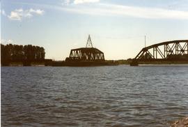
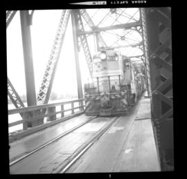
Photograph depicts the CPR Mission Bridge on the Huntingdon Branch. It shows the daily southbound way freight train at about 12:30 hours STD time, crossing the bridge. The train consisted of two locomotives, about 35 cars, and a 1920 wooden caboose. The lead locomotive was CPR 8510, GM class 0-4-4-0, built in 1954. There is a 10 mph speed restriction on the bridge.
Photograph depicts the disused CPR Kettle Valley Railway line in Penticton. The trackage leads from the lakefront to the main yards. All the track was removed by July 1981. The view is looking northeast to the lake and the Incola Hotel.
Photograph depicts the CPR depot at Okanagan Falls, located at mile 10.6 from Penticton. The depot is locked and unused but it used to be the southern terminus of Skaha Lake when the line first opened in 1922. When the route along the edge of Skaha Lake was built, the Okanagan lost its barge and car slips in 1931. There is also a water pump at the right of the depot.
Photograph depicts the CPR line at Arawana, 5 miles northeast of Penticton. It was formerly a depot and water stop, then a passing loop and spur, and now nothing. The building in the photo is a typical track trolley shanty.
Photograph depicts the Chute depot at mile 106.5 on the CPR line in the Carmi Subdivision. It is a totally isolated location, but not reachable by road. The photo shows the only surviving large building. The rail here is dated 1942.
Photograph depicts the McCulloch CPR depot at mile 76.6 on the Carmi Subdivision. The depot was painted blue inside. The last passenger train was seen 17 January 1964 and the last freight train on the 19 May 1973.
Photograph depicts the McCulloch CPR depot located at mile 76.7 on the Carmi Subdivision, which is about 27 miles northeast of Penticton. The building on the right is the passenger depot, which was last officially used in January 1964. The view is looking south on the downgrade.
Photograph depicts the washrooms on the west side of the line, about a quarter mile from the McCulloch CPR depot building. The depot is located at mile 76.6 on the Carmi Subdivision.
Photograph depicts the Grand Forks CPR depot, located at mile 94.8 on the Boundary Subdivision, which runs from Nelson to Midway (127 miles). It was originally built by the Columbia & Western Railway in 1899. IT has not seen a passenger train in years but it is still in use for administrative purposes.
Photograph depicts the Nelson CPR depot, built in 1899. Since there are no passenger trains, freights used the front line, adjacent to the depot. The photograph was taken from the platform and shows a view looking east.
Photograph depicts the Nelson CPR depot, built in 1899 and still well-maintained. Streetcars had a terminal in this yard from 1899-1949, for what was probable the shortest street car system in Canada. The view is looking north and shows the rear view.
Photograph depicts two grain elevators at Creston, BC. The Creston CPR yard lies behind the camera. The line is on a downgrade away from the camera, starting its descent to the valley bottom for Kootenay Lake. The grain elevators are a rare sight in BC.
Photograph depicts a former icehouse at the Nelson CPR depot. It is located about 150 yards west of the main depot building. It also shows service boxcar CPR #412120, on the right track. The view is looking east.
Photograph depicts the CPR line at McConnell, BC, which is located at mile 55 on the Nelson Subdivision and 12 miles east of Creston. The view includes the signalman's shanty, which is still in occasional use.
Photograph depicts a surviving but disused water tower at Cranbrook. Cranbrook is located at mile 0 on the CPR line of the Nelson Subdivision.
Photograph depicts the CPR depot at Castlegar. The left-hand track leads to Trail and the right-hand track to Midway and Penticton. The picture was taken at about 1 pm with the Nelson to Midway way freight train standing at the depot. The caboose was built in 1913. The view is looking west.
Photograph depicts the only surviving building in the ghost town of Gerard. Its survival was due to the ownership and periodic use of the B.C. Government Fisheries Department.
Photograph depicts one of the remaining old type of houses left on Beach Ave., Vancouver.
Photograph depicts a house on the east side of Ontario Street, Vancouver.
Photograph depicts the Kaslo City Hall, built in 1898. The first floor contained a library while the second floor held a coutroom with original furnishings in mild disarray.
Photograph depicts St. Ann's Academy, a girls boarding school that was close to the centre of Victoria. In the corner of the property, nuns had established the first school in B.C. in 1853.
Photograph depicts Windsor School, an elementary school in south Burnaby.
Photograph depicts St. Ann's Academy, a girls boarding school that was close to the centre of Victoria. Captured the front of the main building.
Photograph depicts Mount Pleasant Elementary School in Vancouver. Date over doorway was 1892.
Photograph depicts a courthouse in Richfield, 1 mile above Barkerville. It was the only building left standing of the former mining community.
Photograph depicts St. John the Divine church, built in 1914 at Hubert which is now a ghost town. Moved to this location in the open country in 1928.
Photograph depicts Kach Indian church.
Photograph depicts an old hotel in the center of Keremeos. It once had been a thriving staging post. The village now only contained 2 building which included this hotel and a dance hall that had been converted to a barn.
Photograph depicts Windsor Hotel, the only survivor of about 5 hotels that were in the area.
Photo depict Movat's store where you could buy food, dry goods, and hardware among other things. Located beside the original pier on Salt Spring Island, now little used for general and commercial traffic.
Photograph depicts the Westholme post office.
Photograph depicts an RCAF Langer that was erected in 1942 as part of a flying boat base to counter possible Japanese sea and activities. It was used subsequently as whaling station premises.
Photograph depicts the demolished site of Nelson Laundries Ltd. The boiler in the foregorund was having tubes removed by a wrecker. The site was to be occupied by a Ford motor dealer.
Photograph depicts West Coast Electric Ltd., an electric manufacturers and shop.
Photograph depicts a cabin near Williams Lake. Its interior contained two old treadle sewing machines and a chesterfield. Davies had the impression it had not been inhabited for at least a decade.
Photograph depicts a log cabin in the KlinaKlina Valley.
Photograph depicts an original trappers cabin on Staubert Lake.
Photograph depicts a trappeers cabin on the northend of Trout Lake and Trout Lake City. It was maintained in good condition by present owners who valued its age.
Photograph depicts a cattle shed located 3 miles east of Pavilion Lake, which is 15 miles northeast of Lillooet. It may have been a settler's cabin at one time.
Photograph depicts the yard at the Hat Creek Ranch. Hat Creek used to be a staging post on the Cariboo Road.
Photograph depicts an abandoned cabin about 100 yards from the Fraser River on Bridge River road, about 2 miles out of Lillooet.
Photograph depicts a new CN overpass in Campbell Creek. Looking at new eastbound lane of the Trans Canada Highway. It was all paid for by the Provincial Department of Highways in order to convert the 2 lanes into 4 in order to improve visibility and stretch the highway.
Photograph depicts a new bridge on the CNR Okanagan Branch. The old steel bridge on the right had been dismantled.
Photograph taken looking north, with a spur in the foreground. It was used by ore mixed freight daily. It was believed that at the bottom of the grade was a junction with a GNR branch that ran from the US border south of Creston to Kootenay Lake (built in 1904, then was hardly used, finally ceased in 1910).
Photograph depicts a CNR bascule bridge across the upper waters of Victoria Harbour. The rest of the trackage had been removed, except for the bridge itself.
Photograph depicts the CPR Pitt River swing bridge in an open position.
Photograph depicts a CPR swing bridge in Harrison Mills. Looking west, on the upstream side of the Harrison River.
Photograph depicts a swing bridge in Harrison Mills. It was rarely used, but all its controls were modern and maintained.