1996.8.2
·
Séries
·
1954-1967
Parte de Chander Suri fonds
2 resultados con objetos digitales
Muestra los resultados con objetos digitales
1996.8.2.01
·
Dossiê
·
1954
Parte de Chander Suri fonds
File consists of a preliminary study undertaken by the Lower Mainland Regional Planning Board of B.C. examining the growing metropolitan populaton of Greater Vancouver. Includes a report on the findings in member municipalites.
1996.8.2.11
·
Dossiê
·
[1956?]
Parte de Chander Suri fonds
File consists of a brief developed by the Lower Mainland Regional Planning Board of B.C. examining the problems with expanding urban sprawl in Greater Vancouver, outlining the findings of the research, and offering future suggestions.
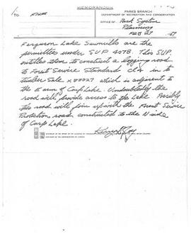
1996.8.1.353
·
Item
·
September 1956
Parte de Chander Suri fonds
A b&w (photocopy) map of British Columbia Forest Service, Forest Surveys and Inventory Division index to the Interim Forest Cover Series and the Forest Inventory Area Reference System. Produced by the Department of Lands and Forests British Columbia.
1996.8.1.350
·
Item
·
1 July 1957
Parte de Chander Suri fonds
A b&w (photocopy) map of British Columbia Forest Service, Forest Surveys and Inventory Division index to the Interim Forest Cover Series and the Forest Inventory Area Reference System.
1996.8.1.351
·
Item
·
1 July 1957
Parte de Chander Suri fonds
A b&w (photocopy) map of British Columbia Forest Service, Forest Surveys and Inventory Division index to the Interim Forest Cover Series and the Forest Inventory Area Reference System.
1996.8.2.02
·
Dossiê
·
1959
Parte de Chander Suri fonds
File consists of a report by the Lower Mainland Regional Planning Board of B.C. outlining a continued program of housing research for the Greater Vancouver Area. The report examines similar experiences of other urban cities and outlines the proposed program for housing analysis.
1996.8.1.337
·
Item
·
1960, 1970 (?)
Parte de Chander Suri fonds
14 pieces of b&w (photocopy) papers most of which are unidentified tracings. The cellophane tape residues on the edges of the papers indicate that they used to be taped together. Plans could be related to Berman Lake, Nadsilnich Lake and Chief Lake. Produced by Fish and Wildlife Branch Department of Recreation and Conservation.
1996.8.2.03
·
Dossiê
·
1961
Parte de Chander Suri fonds
File consists of a report undertaken by the Lower Mainland Planning Board of B.C. forecasting the future of industrial land prospects. This report is part of a larger study of industrial settlement in the province.
1996.8.2.04
·
Dossiê
·
1961
Parte de Chander Suri fonds
File consists of a study examining the residential land structure of Metropolitan Vancouver. This study is supplementary to the Land for Living study. Includes one report of the findings and analysis of the study.
1996.8.1.392
·
Item
·
1961
Parte de Chander Suri fonds
A colour map illustrating the controur interval of a region in around Victoria B.C.
1996.8.2.05
·
Dossiê
·
1961
Parte de Chander Suri fonds
File consists of a report by the Lower Mainland Regional Planning Board of B.C. regarding the needs of industrial land. The report describes methods for carrying out these needs with suitable sites in the Lower Mainland area.
1996.8.2.06
·
Dossiê
·
1962
Parte de Chander Suri fonds
File consists of a report by the Lower Mainland Regional Planning Board of B.C. on the future industrial land prospects of the Lower Mainland.
1996.8.2.07
·
Dossiê
·
1962
Parte de Chander Suri fonds
File consists of a report by the Lower Mainland Regional Plannng Board of BC concerning availible farming land in the Lower Mainland.
1996.8.1.323
·
Item
·
1963
Parte de Chander Suri fonds
A b&w map illustrating subdivision of Prince George B.C.
1996.8.2.10
·
Dossiê
·
1963
Parte de Chander Suri fonds
File consists of a report by the Lower Mainland Regional Planning Board of B.C. regarding the facilities that serve households and standards of lower mainland dwelling facilities. The study correlates with a larger "Land for Living" report about land development in the Lower Mainland.
1996.8.1.325
·
Item
·
1963
Parte de Chander Suri fonds
A b&w map illustrating subdivision of a region in B.C. Fraser River is identified on the map.
1996.8.1.322
·
Item
·
1963
Parte de Chander Suri fonds
A b&w map illustrating subdivision of an region in BC. Nechako River, is identified on the map.
1996.8.1.324
·
Item
·
1963
Parte de Chander Suri fonds
A b&w map illustrating subdivision of region close to Prince George and areas in Northern B.C.
1996.8.2.08
·
Dossiê
·
1963
Parte de Chander Suri fonds
File consists of a report by the Lower Mainland Regional Plannng Board of BC concerning availible land in the Lower Mainland.
1996.8.2.09
·
Dossiê
·
1963
Parte de Chander Suri fonds
File consists of a study by the Lower Mainland Regional Planning Board of B.C. regarding the attitudes of residents in the Greater Vancouver fringe areas toward their environment. The study was part of the larger "Land for Living" report about land development in the Lower Mainland. Includes Part 1 and Part 2 of the report detailing survey structure, findings, and interpretation.
Dossiê
·
1964-1970
Parte de Chander Suri fonds
1996.8.1.021
·
Item
·
Feb 1964
Parte de Chander Suri fonds
6 plans produced by Briggs Greenwell Associates. 1581 4th Ave PG BC
1996.8.2.12
·
Dossiê
·
[between 1965 and 1967]
Parte de Chander Suri fonds
File consists of a petition by the Union of British Columbia Municipalities against the Amchitka Nuclear Test by the Atomic Energy Commission of the United States of America.
1996.8.1.186
·
Item
·
1965
Parte de Chander Suri fonds
This colour map is produced by the Army Survey Establishment, R.C.E. Copies may be obtained from the Map Distribution Office Department of Mines and Technical Survey, Ottawa.
1996.8.1.439
·
Item
·
1967
Parte de Chander Suri fonds
A blueprint plan of subdivision of part of block 162, Seymour District. Esquimalt and Nanaimo Railway are identified on the plan.
1996.8.1.355
·
Item
·
3 Oct 1967
Parte de Chander Suri fonds
A blueprint plan of the site plan of a house. Produced by Industrial Design and Drafting Service. Williams Cres. and Fraser River are identified on the plan.
1996.8.1.359
·
Item
·
16 Oct 1967
Parte de Chander Suri fonds
A blueprint plan of the section plan of a building. Produced by Industrial Design and Drafting Service.
1996.8.1.360
·
Item
·
16 Oct 1967
Parte de Chander Suri fonds
A blueprint plan of a building. Produced by Industrial Design and Drafting Service.
1996.8.1.022
·
Item
·
30 Oct 1967
Parte de Chander Suri fonds
4 Plans produced by Industiral Design and Drafting Service Prince George BC.
1996.8.1.445
·
Item
·
February 1968
Parte de Chander Suri fonds
Series of plans showing addition to Fraser Lake Elementary Secondary School: (1) Site Plan; (2) Floor & Roof Beams, Foundation Plan & Details; (3) Floor Plan, Schedules & Details; (4) Elevations & Sections; (5) Wall Sections; (6) Room Elevations & Cabinet Details.
1996.8.1.457
·
Item
·
March 1968
Parte de Chander Suri fonds
Series of plans showing proposed construction: (1) Site Plan; (2) Foundation Plan & Details at 97.50; (3) Basement Plan & Sections at 100.00; (4) Floor Framing Plan & Details; (5) Plan at 108.33; (6) Elevations.
1996.8.1.450
·
Item
·
July 1968
Parte de Chander Suri fonds
Colour-coded topographic plan depicting the various routes of transportation and communication in a primarily residential area along the Fraser River in Prince George.
1996.8.1.448
·
Item
·
July 1968
Parte de Chander Suri fonds
Colour-coded topographic plan depicting various land reservations in a primarily residential area along the Fraser River in Prince George.
1996.8.1.451
·
Item
·
July 1968
Parte de Chander Suri fonds
Colour-coded plan depicting the various topographic sections in a primarily residential area along the Fraser River in Prince George.
1996.8.1.452
·
Item
·
July 1968
Parte de Chander Suri fonds
Colour-coded topographic plan depicting residential, industrial, and public zoning in a primarily residential area along the Fraser River in Prince George.
1996.8.1.447
·
Item
·
July 1968
Parte de Chander Suri fonds
Colour-coded topographic plan depicting various ownership rights in a primarily residential area along the Fraser River in Prince George.
1996.8.1.449
·
Item
·
July 1968
Parte de Chander Suri fonds
Colour-coded topographic plan depicting residential, industrial, and public zoning in a primarily residential area along the Fraser River in Prince George.
1996.8.1.285
·
Item
·
1971
Parte de Chander Suri fonds
Eleven blueprint plans attached together re property development for Mr and Mrs. K. Schurer. Produced by Tom West, B. ARCH. M.R.A.I.C. Architect Prince George BC. They show site plan, foundation plan, ground floor plan, second floor plan, elevation and section, elevations, building sections, fullsize details, heating layout, and specifications.
1996.8.1.230
·
Item
·
1972
Parte de Chander Suri fonds
A blueprint plan re Highway Right-of-Way through Lot A. Plan 19885, Block 162, Seymour District. Illustrates section, lot and block divisions of Seymour district. Land surveyor Michael H. Hanson. This plan includes traverse table and legend.
1996.8.1.440
·
Item
·
1972
Parte de Chander Suri fonds
A blueprint plan of highway right-of-way through lot A, plan 19885, block 162, Seymour District. Cowichan Valley Road is identified on the plan.
1996.8.1.365
·
Item
·
1973-1975
Parte de Chander Suri fonds
21 blueprint plans attached together re Cabaret-Banquet Centre for Mr. J. Lalikeas Spartan Catering LTD. Architect: Tom West. Consultants: McKenzie Snowball and Skalbania Associates LTD. "Set#4"
1996.8.1.327
·
Item
·
1973
Parte de Chander Suri fonds
A blueprint plan of a region in Cariboo district. Giscome Road, Hedlund Road are identified on the plan. Plan of Subdivision of Lot 1. Plan 16115 District Lot 636 Cariboo District, British Columbia
1996.8.1.222
·
Item
·
1973
Parte de Chander Suri fonds
The plan is a photocopy which illustrates closing part of cross street as shown on plan 1268, adjoining lots 8 to 15, block 17 and lots 2 to 5, block 18, plan 1268, D.L. 343, Cariboo district. This plan lies within the Fraser-Fort George Regional District. It is produced by McWilliam, Whyte, Goble and Associates B.C. Land Surveyors Prince George-Kamloops-Smithers.
1996.8.1.249
·
Item
·
28 June 1973
Parte de Chander Suri fonds
A blueprint produced by Strong Lamb and Nelson (Kamloops) LTD. It shows the plan the foundation plan and sections.
1996.8.1.250
·
Item
·
4 July 1973
Parte de Chander Suri fonds
A blueprint produced by Strong Lamb and Nelson (Kamloops) LTD. It shows the plan the roof framing and sections.
1996.8.1.251
·
Item
·
6 July 1973
Parte de Chander Suri fonds
A blueprint produced by Strong Lamb and Nelson (Kamloops) LTD. It shows the site plan of a building.
1996.8.1.252
·
Item
·
6 July 1973
Parte de Chander Suri fonds
A blueprint produced by Strong Lamb and Nelson (Kamloops) LTD. It shows the general notes and typical details of a building.
1996.8.1.248
·
Item
·
6 July 1973
Parte de Chander Suri fonds
A blueprint produced by Strong Lamb and Nelson (Kamloops) LTD. It shows the plan for first floor and front elevation of a building.
1996.8.1.016
·
Item
·
1974-75
Parte de Chander Suri fonds
Composed of eleven detailed/zoomed maps and one overall map of the city of Prince George.
Map produced by City of Prince George Engineering Department.