Item is a photocopied version of "Tourism: For Better or For Worse: Taming the Dragons of Growth and Change" speech presented to Regional Tourism Workshops by A. Pollock.
Item is a photocopied version of a draft "Tofino Regional Tourism Study Executive Summary" by Ric Careless.
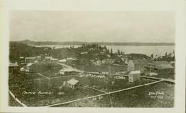
Wide angle photograph showing the intersection of 3rd Avenue and 6th Street, as well as 5th Street in Prince Rupert. Many buildings are visible along the wooden street including a building in mid-construction. Annotation on recto reads: "Prince Rupert, BC. 6th Street 3rd Ave. 5th St Allen Photo Aug 6/09."
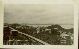
Wide angle photograph showing 3rd and 2nd Avenue in Prince Rupert. Many buildings, both commercial and residential, and some tents are situated along the wooden roads. Annotation on recto reads: "Prince Rupert, BC. 3rd Avenue 2nd Avenue Allen Photo Aug 6/09."
Item is a copy of the 1981 "The Vegetation of Burns Bog, Fraser Delta, Southwestern British Columbia" by Hebda, R.J. and W.G. Biggs in Syesis (Vol. 14) published by British Columbia Provincial Museum.
Item is a copy of "The Role of Aerial Photography in the Canada Land Inventory Classification Program" prepared by Gimbarzevsky, P. for the Canadian Forestry Service Department of the Environment for Commission VII International Society for Photogrammetry.
Item is a photocopied 1986 University of California Berkeley research paper by Philip Girard entitled "The Regulation of Agricultural Land in Canada: A Decade of Innovation, 1974-1984".
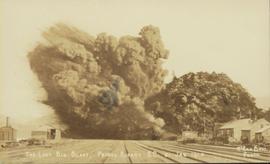
Photograph of a large explosion next to a huge pile of debris. Buildings are visible on either side and railroad track can be seen in the foreground. Printed annotation on recto reads: "The Last Big Blast, Prince Rupert BC 21 Jan 1914 McRae Bros. Photo"
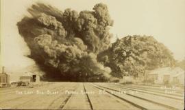
Photograph of a large explosion next to a huge pile of debris. Buildings are visible on either side and railroad track can be seen in the foreground. Annotation on recto reads: "The Last Big Blast, Prince Rupert BC 21 Jan 1914 McRae Bros. Photo"
This "The Land is Yours" film is a promotional film produced by the British Columbia Department of Agriculture in Kelowna, ca. 1968 or 1969. The film was produced by Gary Runka and hosted by Russ Richardson. Runka and Richardson provide commentary throughout the film. The film was directed by Nobert Hartig.
Item is a photocopied reprint of Tisdale's "The Grasslands of the Southern Interior of British Columbia" in the Ecology journal, Vol. 28 No. 4.
Item is a photocopied version of "The Gitxsan Model: An Alternative to the Destruction of Forests, Salmon and Gitxsan Land" booklet by Eco-Research Chair of Environmental Law and Policy, University of Victoria, BC.
Item is a copy of "The Future of Animal Production in Canada", a Klinck Lecture by Dr. W.D. Morrison at Agriculture Institute of Canada.
Item is an original copy of "The Fraser Valley Gas Project" presentation to Commission on Fraser Valley Petroleum Exploration.
Item is an original copy of "Effects of Pipelines on Fraser Valley Farmland" prepared by Interwest Property Services Ltd. for Westcoast Transmission Co. Ltd.
Item is a faxed copy of a speech by Melvin H. Smith, QC, entitled "The Delgamuukw Case--What does it mean and what do we do now?" which was delivered to the Vancouver Board of Trade on February 10, 1998.
Item is a 1980 paper entitled "The Bog Forests" by the Corporation of the Township of Richmond Environmental Control Officer and Planning Department.
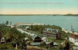
Hand coloured lofty view of the Prince Rupert waterfront. Printed annotation on recto reads: "The Beginning of Prince Rupert, B.C. : Grand Trunk Pacific Hotel in foreground." Artist's stamp in lower left corner reads: "104,036 J.V."
Item is an original copy of an Agricultural Land Commission promotional booklet from 1975 entitled "The B.C. Land Commission - Keeping the Options Open".
Publication is entitled "The Alaska Panhandle Boundary Dispute" by Hugh Finsten of the Research Branch, Library of Parliament.
Item is an original copy of a 1982 technical report presented to the British Columbia Utilities Commission by G.E. Cheesman and R.L. Davis of the Ministry of Environment Air Studies Branch entitled "The Agroclimate of the Peace River Valley and a Comparison with other Locations in British Columbia".
Disc contains a single file, "GGR 2A.ppt", which is a PowerPoint presentation by Gary Runka entitled "The Agriculture Land Reserve: What it is and how it got here" created April 18, 2002.
Item is an original copy of a 1979 promotional booklet produced by the BC Agricultural Land Commission entitled "The Agricultural Land Reserve: Protecting B.C.'s Farmland". The booklet was prepared for the Provincial Agricultural Land Commission by J.M. Sawicki. Photographs by G.G. Runka.
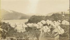
Item is a print of a photograph of tents and newly cleared land in Prince Rupert taken between 1906 and 1908.
Gathering of tents in Vickersville with the harbour and mountains in the distance. Annotation on recto reads: "Vickersville Prince Rupert o/n[?] 1908."
Item is an original copy of "Ten Years of Agricultural Land Preservation" the 1983 anniversary publication by the Provincial Agricultural Land Commission.
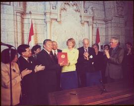
The group stands in front of an ornate stone wall and two Canadian flags.
Handwritten annotation on photograph enclosure reads: “8/6/99. Dear Lady, When I saw this photograph I knew there was a certain person who would truly appreciate and ‘feel’ its significance. Not many steps left to take now . . . . your unwavering support is never more appreciated. best personal regards, Peter”; handwritten annotation on verso reads: “Nisga’a”.
Audio cassette annotated "Tape 9 - Dec. 11, 1993 - 4:15-5:00 pm" is believed to be an audio recording of a workshop for the East Kootenay CORE project.
Audio cassette annotated "Tape 8 - Dec. 11, 1993 - 2:10-4:15 pm" is believed to be an audio recording of a workshop for the East Kootenay CORE project.
Audio cassette titled "Tape 7: 5:10-5:50" is believed to contain a recording of a workshop related to the Vernon commonage project.
Audio cassette annotated "Tape 7 - Dec. 11, 1993 - 11:40 am-2:10 pm" is believed to be an audio recording of a workshop for the East Kootenay CORE project.
Audio cassette titled "Tape 6: 4:05-5:10" is believed to contain a recording of a workshop related to the Vernon commonage project.
Audio cassette annotated "Tape 6 - Dec. 11, 1993 - 9:50-11:40 am" is believed to be an audio recording of a workshop for the East Kootenay CORE project.
Audio cassette titled "Tape 5: 2:45-4:05" is believed to contain a recording of a workshop related to the Vernon commonage project.
Audio cassette annotated "Tape 5 - Dec. 10, 1993 - 8:10-9:44 pm - Dr. Thomas Powers / Dec. 11, 1993 - 8:30-9:50 am" is believed to be an audio recording of a workshop for the East Kootenay CORE project.
Audio cassette annotated "Powers Dec. 10" is believed to be an audio recording of a workshop for the East Kootenay CORE project.
Audio cassette titled "Tape 3 - Dec. 10, 1993 - 5:00-" is believed to be an audio recording of a workshop for the East Kootenay CORE project.
Audio cassette titled "Tape 2 - Dec. 10, 1993 - 1:45-5:00" is believed to be an audio recording of a workshop for the East Kootenay CORE project.
Audio cassette titled "Tape 1 - Dec. 10, 1993 - 9:30-1:45 - KBR" is believed to be an audio recording of a workshop for the East Kootenay CORE project.
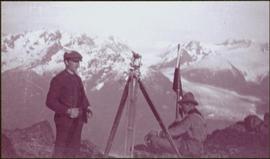
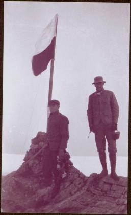
Photograph depicts two men on either side of camera on tripod, flag visible behind them. Mountain range and glacier in background.
Image is one of 65 photos documenting a survey of the Canada-Alaska Boundary, Taku River area, May 23 to Oct. 15, 1906. This particular photo is one of 9 found in original enclosure with the following handwritten annotation: "Pictures of different members of ‘our’ party.” See also items 2006.20.3.57 - 2006.20.3.65.
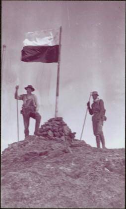
Photograph depicts two unidentified men standing to right of flag mounted in rock pile.
Image is one of 65 photos documenting a survey of the Canada-Alaska Boundary, Taku River area, May 23 to Oct. 15, 1906.
This particular photo is one of 13 found in original enclosure with the following handwritten annotation: "SOME OTHERS." See also items 2006.20.3.22 - 2006.20.3.34.
Photograph depicts two unidentified men standing to right of flag mounted in rock pile.
Image is one of 65 photos documenting a survey of the Canada-Alaska Boundary, Taku River area, May 23 to Oct. 15, 1906. This particular photo is one of 10 found in original enclosure with the following handwritten annotation: "From [Wahut?]-Azmuth and Koshu.” See also items 2006.20.3.47 - 2006.20.3.56.
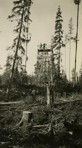
Photograph depicts two surveyors (Jack Lee, Gordon Wyness, or Philip Monckton) taking bearings from Pineview Station tower east of Prince George. Their surveying transit and telescope are visible in the image.
Disc contents unknown (failed migration).
Item is an original Canada Department of Agriculture Publication 1179 entitled "Suitability for Irrigation of Water from Lakes and Streams in the Southern Interior of British Columbia".
