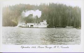
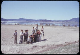
Group stands in foreground on what appears to be a wooden teeter totter. Fence crosses midground in front of water, and hills can be seen on opposite shore in background. Handwritten annotation on recto of mounted slide reads: "play ground in Legak [sic]".
Photograph depicts glacier in valley below mountains. Handwritten annotation on negative: "K. Glacier [...illegible]".
Image is one of 65 photos documenting a survey of the Canada-Alaska Boundary, Taku River area, May 23 to Oct. 15, 1906.
This particular photo is one of 13 found in original enclosure with the following handwritten annotation: "Kopoka River - river scenes Aug 29 to Oct. 9 [19]06". See also items 2006.20.3.1 - 2006.20.3.13.
Photograph depicts tent among trees, hills visible in background.
Image is one of 65 photos documenting a survey of the Canada-Alaska Boundary, Taku River area, May 23 to Oct. 15, 1906.
This particular photo is one of 13 found in original enclosure with the following handwritten annotation: "Kopoka River - river scenes Aug 29 to Oct. 9 [19]06". See also items 2006.20.3.1 - 2006.20.3.13.
Photograph depicts river and rocky shores, glacier visible on mountain in background. Handwritten annotation on negative: "Glacier [?] Kopoka".
Image is one of 65 photos documenting a survey of the Canada-Alaska Boundary, Taku River area, May 23 to Oct. 15, 1906.
This particular photo is one of 13 found in original enclosure with the following handwritten annotation: "Kopoka River - river scenes Aug 29 to Oct. 9 [19]06". See also items 2006.20.3.1 - 2006.20.3.13.
Photograph depicts two unidentified men standing and sitting at campfire by large fallen trees. Forest and mountains in background. Handwritten annotation on negative: "[?] Taken Near Kopoka".
Image is one of 65 photos documenting a survey of the Canada-Alaska Boundary, Taku River area, May 23 to Oct. 15, 1906.
This particular photo is one of 8 found in original enclosure with the following handwritten annotation: "From main camp up Kopoka River. Scenes with persons in." See also items 2006.20.3.14 - 2006.20.3.21.
Photograph depicts unknown man standing in water while pulling loaded canoe by rope. Rocky shore in foreground, mountains in background. Handwritten annotation visible on negative: "[?] hauling canoe. Big [?], Kopoka".
Image is one of 65 photos documenting a survey of the Canada-Alaska Boundary, Taku River area, May 23 to Oct. 15, 1906.
This particular photo is one of 8 found in original enclosure with the following handwritten annotation: "From main camp up Kopoka River. Scenes with persons in." See also items 2006.20.3.14 - 2006.20.3.21.
Photograph depicts three unknown men standing in water while pulling loaded canoe by rope. Rocky shore and hills in background. Illegible handwritten annotation visible on negative: "...[K. River]?" (Kopoka?)
Image is one of 65 photos documenting a survey of the Canada-Alaska Boundary, Taku River area, May 23 to Oct. 15, 1906.
This particular photo is one of 8 found in original enclosure with the following handwritten annotation: "From main camp up Kopoka River. Scenes with persons in." See also items 2006.20.3.14 - 2006.20.3.20.
Photograph depicts man [Gilroy?] sitting with small tin cup. Canoe lies upside down in foreground. Water and opposite shore visible in background. Handwritten annotation visible on negative: "Camp. [Gilroy?] on way up from trail. 9 pm".
Image is one of 65 photos documenting a survey of the Canada-Alaska Boundary, Taku River area, May 23 to Oct. 15, 1906.
This particular photo is one of 13 found in original enclosure with the following handwritten annotation: "SOME OTHERS." See also items 2006.20.3.22 - 2006.20.3.34.
Photograph depicts two unidentified men standing to right of flag mounted in rock pile.
Image is one of 65 photos documenting a survey of the Canada-Alaska Boundary, Taku River area, May 23 to Oct. 15, 1906.
This particular photo is one of 13 found in original enclosure with the following handwritten annotation: "SOME OTHERS." See also items 2006.20.3.22 - 2006.20.3.34.
Photograph depicts two men standing on mountain with walking sticks, carrying bundles on their backs. Valley and mountains visible in background below. Handwritten annotation visible on negative: "[?] Climbing [?] Sta - K. River" (Kopoka?).
Image is one of 65 photos documenting a survey of the Canada-Alaska Boundary, Taku River area, May 23 to Oct. 15, 1906. This particular photo is one of 7 found in original enclosure with the following handwritten annotation: "Around River Taku and main camp on same." See also items 2006.20.3.35 - 2006.20.3.41.
Icebergs can be seen in foreground, opposite shore crosses midground, mountains stand in background.
Image is one of 65 photos documenting a survey of the Canada-Alaska Boundary, Taku River area, May 23 to Oct. 15, 1906. This particular photo is one of 7 found in original enclosure with the following handwritten annotation: "Around River Taku and main camp on same." See also items 2006.20.3.35 - 2006.20.3.41.
Water spans foreground, trees on shore can be seen on far left, mountains stand in background.
Image is one of 65 photos documenting a survey of the Canada-Alaska Boundary, Taku River area, May 23 to Oct. 15, 1906. This particular photo is one of 7 found in original enclosure with the following handwritten annotation: "Around River Taku and main camp on same." See also items 2006.20.3.35 - 2006.20.3.40.
View of snowy mountain range.
Image is one of 65 photos documenting a survey of the Canada-Alaska Boundary, Taku River area, May 23 to Oct. 15, 1906. This particular photo is one of 5 found in original enclosure with the following handwritten annotation: "Boundary No.2 camera Sta. Twin Lake & Glacier.” See also items 2006.20.3.43 - 2006.20.3.46.
Water spans foreground, cliffs cross midground, mountains stand in background.
Image is one of 65 photos documenting a survey of the Canada-Alaska Boundary, Taku River area, May 23 to Oct. 15, 1906. This particular photo is one of 5 found in original enclosure with the following handwritten annotation: "Boundary No.2 camera Sta. Twin Lake & Glacier.” See also items 2006.20.3.42 - 2006.20.3.46.
Photograph depicts mountain range, river or glacier visible below.
Image is one of 65 photos documenting a survey of the Canada-Alaska Boundary, Taku River area, May 23 to Oct. 15, 1906. This particular photo is one of 10 found in original enclosure with the following handwritten annotation: "From [Wahut?]-Azmuth and Koshu.” See also items 2006.20.3.47 - 2006.20.3.56.
Photograph depicts small tent set up in bushes, fallen trees in foreground.
Image is one of 65 photos documenting a survey of the Canada-Alaska Boundary, Taku River area, May 23 to Oct. 15, 1906. This particular photo is one of 10 found in original enclosure with the following handwritten annotation: "From [Wahut?]-Azmuth and Koshu.” See also items 2006.20.3.47 - 2006.20.3.56.
Photograph depicts river or glacier in valley bellow mountains. Handwritten annotation visible on negative: "From No. 2 Cam. Sta. [?] Taku River [?]".
Image is one of 65 photos documenting a survey of the Canada-Alaska Boundary, Taku River area, May 23 to Oct. 15, 1906. This particular photo is one of 10 found in original enclosure with the following handwritten annotation: "From [Wahut?]-Azmuth and Koshu.” See also items 2006.20.3.47 - 2006.20.3.56.
Photograph depicts river or glacier in valley bellow mountains, flat snowy area in foreground.
Image is one of 65 photos documenting a survey of the Canada-Alaska Boundary, Taku River area, May 23 to Oct. 15, 1906. This particular photo is one of 10 found in original enclosure with the following handwritten annotation: "From [Wahut?]-Azmuth and Koshu.” See also items 2006.20.3.47 - 2006.20.3.56.
Photograph depicts men on sternwheeler in river, opposite shore in background.
Printed annotation on recto reads: “S.S. “Charlotte,” Quesnel. B.C.” Handwritten message on verso is addressed to “Mr. O. Winter 1016 V Park St. Victoria B.C.” Cancellation stamp on Canadian 1 cent stamp reads: "ASHCROFT B.C. JUN [10?] 11".
Postcard photograph depicts sternwheeler in river, trees on opposite shore in background.
Printed annotation on recto reads: “Operator 1913, Prince George, B.C. Canada”, handwritten in pencil on verso: “Operator 1913”.
View of snow capped mountains in the distance, vast rolling treed hills in mid ground and a gravel road in the foreground. Road sign indicating severe curve in road situated at the right of the gravel road. Handwritten annotation on verso in pen reads: “Cassiar – Stewart highway”
Photographs within this file document natural and artificial features across the landscape of Northern British Columbia. This landscape also includes the physical, built, urban and industrial landscapes; topography; site plans; boundaries, districts, reserves, parks, sanctuaries, towns, villages and cities, etc.
Photograph depicts a short wooden bridge spanning Dog Creek mid-ground and a stand of trees in the background. There are many Dog Creeks within British Columbia, it is believed this Dog Creek is located just south of Fort St. James, BC. Handwritten photo caption below photograph reads: "Dog Creek".
Photograph depicts a large body of water with trees on opposite bank crossing mid ground and reflected in the water. Mountains visible in distant background. Handwritten photo caption below photograph reads: "Lake Beau Vert and Whistler Mt Jasper Park."
Photograph depicts a glassy body of water with trees on opposite bank crossing mid ground. Mountains visible in distant background. A clear reflection of the trees and mountains is mirrored in the water. Handwritten photo caption below photograph reads: "The Whistlers across Lake Beau Vert (7. AM.)"
Photograph depicts buildings and signage on either side of dirt road. Unidentified man stands on far left, Atlin Lake and mountains can be seen in background.
Hand inscribed annotation on recto of photograph reads: “Pearl St., Atlin, B.C. Aug. 1899. A.C. Hirschfeld, No.74”.
Photograph depicts tent buildings on either side of dirt road. Unidentified men are visible on left, Atlin Lake and mountains can be seen in background.
Hand inscribed annotation on recto of photograph reads: “Pearl Av. looking towards Atlin Lake, Atlin, B.C., A.C. Hirschfeld, No. 174”
Front view of an abandoned log building. The door is open or missing, the front window glass is broken, the area in front of the building is littered with antlers, boxes and wood. The tree next to the building has grown too close the building and roof. Handwritten annotation on verso in pen reads: “Laketon, Dease Lake, BC. Court house & jail June ‘62”
Photographs within this file pertain to the early exploration of northern British Columbia.
Photograph depicts rocks among river rapids, opposite shore in background. Handwritten annotation on negative: "Rough water rap".
Image is one of 65 photos documenting a survey of the Canada-Alaska Boundary, Taku River area, May 23 to Oct. 15, 1906.
This particular photo is one of 13 found in original enclosure with the following handwritten annotation: "Kopoka River - river scenes Aug 29 to Oct. 9 [19]06". See also items 2006.20.3.2 - 2006.20.3.13.
Photograph depicts valley; rocky area in foreground, mountains in background. Handwritten annotation on negative: "[M?] Glacier main camp".
Image is one of 65 photos documenting a survey of the Canada-Alaska Boundary, Taku River area, May 23 to Oct. 15, 1906.
This particular photo is one of 13 found in original enclosure with the following handwritten annotation: "Kopoka River - river scenes Aug 29 to Oct. 9 [19]06". See also items 2006.20.3.1 - 2006.20.3.13.
Mountains stand behind water in background. Handwritten annotation on negative: "looking [over?] Kopoka".
Image is one of 65 photos documenting a survey of the Canada-Alaska Boundary, Taku River area, May 23 to Oct. 15, 1906.
This particular photo is one of 13 found in original enclosure with the following handwritten annotation: "Kopoka River - river scenes Aug 29 to Oct. 9 [19]06". See also items 2006.20.3.1 - 2006.20.3.13.
Photograph depicts two unidentified men on small boat with sail, opposite shore in background. Handwritten annotation on negative: "Prospectors on Taku Sailing".
Image is one of 65 photos documenting a survey of the Canada-Alaska Boundary, Taku River area, May 23 to Oct. 15, 1906.
This particular photo is one of 13 found in original enclosure with the following handwritten annotation: "Kopoka River - river scenes Aug 29 to Oct. 9 [19]06". See also items 2006.20.3.1 - 2006.20.3.13.
Photograph depicts river water in foreground, mountains in background. Handwritten annotation on negative: "Rough Water, Kopoka".
Image is one of 65 photos documenting a survey of the Canada-Alaska Boundary, Taku River area, May 23 to Oct. 15, 1906.
This particular photo is one of 13 found in original enclosure with the following handwritten annotation: "Kopoka River - river scenes Aug 29 to Oct. 9 [19]06". See also items 2006.20.3.1 - 2006.20.3.12.
Photograph depicts three unidentified men loading canoe on river shore.
Image is one of 65 photos documenting a survey of the Canada-Alaska Boundary, Taku River area, May 23 to Oct. 15, 1906.
This particular photo is one of 8 found in original enclosure with the following handwritten annotation: "From main camp up Kopoka River. Scenes with persons in." See also items 2006.20.3.14 - 2006.20.3.21.
Photograph depicts silhouette of unknown man standing in front of tent, trees in background. Poor image quality.
Image is one of 65 photos documenting a survey of the Canada-Alaska Boundary, Taku River area, May 23 to Oct. 15, 1906.
This particular photo is one of 13 found in original enclosure with the following handwritten annotation: "SOME OTHERS." See also items 2006.20.3.22 - 2006.20.3.34.
Handwritten annotation visible on negative reads: "Valley of R. [Hills?] across Taku in distance."
Image is one of 65 photos documenting a survey of the Canada-Alaska Boundary, Taku River area, May 23 to Oct. 15, 1906.
This particular photo is one of 13 found in original enclosure with the following handwritten annotation: "SOME OTHERS." See also items 2006.20.3.22 - 2006.20.3.34.
Photograph depicts white water rapids between rocks of river. Forest on opposite shore in background, tree branches in foreground.
Image is one of 65 photos documenting a survey of the Canada-Alaska Boundary, Taku River area, May 23 to Oct. 15, 1906.
This particular photo is one of 13 found in original enclosure with the following handwritten annotation: "SOME OTHERS." See also items 2006.20.3.22 - 2006.20.3.34.
Image is one of 65 photos documenting a survey of the Canada-Alaska Boundary, Taku River area, May 23 to Oct. 15, 1906.
This particular photo is one of 13 found in original enclosure with the following handwritten annotation: "SOME OTHERS." See also items 2006.20.3.22 - 2006.20.3.34.
Photograph depicts narrow waterfall in steep cliff, trees and bushes visible above. Handwritten annotation visible on negative: "Waterfall on way up Taku River."
Image is one of 65 photos documenting a survey of the Canada-Alaska Boundary, Taku River area, May 23 to Oct. 15, 1906. This particular photo is one of 7 found in original enclosure with the following handwritten annotation: "Around River Taku and main camp on same." See also items 2006.20.3.35 - 2006.20.3.41.
Photograph features iceberg floating in water, mountains on shore in background.
Image is one of 65 photos documenting a survey of the Canada-Alaska Boundary, Taku River area, May 23 to Oct. 15, 1906. This particular photo is one of 7 found in original enclosure with the following handwritten annotation: "Around River Taku and main camp on same." See also items 2006.20.3.35 - 2006.20.3.41.
Water spans foreground, wind-blown trees stand on shore in background. Mountains visible in distance.
Image is one of 65 photos documenting a survey of the Canada-Alaska Boundary, Taku River area, May 23 to Oct. 15, 1906. This particular photo is one of 5 found in original enclosure with the following handwritten annotation: "Boundary No.2 camera Sta. Twin Lake & Glacier.” See also items 2006.20.3.42 - 2006.20.3.46.
Photograph depicts valley in snowy mountain range. Handwritten annotation visible on negative: "Pan. From Camera Sta no w. looking at [?] Glacier."
Image is one of 65 photos documenting a survey of the Canada-Alaska Boundary, Taku River area, May 23 to Oct. 15, 1906. This particular photo is one of 5 found in original enclosure with the following handwritten annotation: "Boundary No.2 camera Sta. Twin Lake & Glacier.” See also items 2006.20.3.42 - 2006.20.3.46.
Water spans foreground, trees can be seen in water, trunks submerged. Opposite shore and mountains in background.
Image is one of 65 photos documenting a survey of the Canada-Alaska Boundary, Taku River area, May 23 to Oct. 15, 1906. This particular photo is one of 5 found in original enclosure with the following handwritten annotation: "Boundary No.2 camera Sta. Twin Lake & Glacier.” See also items 2006.20.3.42 - 2006.20.3.45.
Water spans foreground, mountains of opposite shore stand in background.
Image is one of 65 photos documenting a survey of the Canada-Alaska Boundary, Taku River area, May 23 to Oct. 15, 1906. This particular photo is one of 10 found in original enclosure with the following handwritten annotation: "From [Wahut?]-Azmuth and Koshu.” See also items 2006.20.3.47 - 2006.20.3.56.
River flows through rocky area, mountains visible in background.
Image is one of 65 photos documenting a survey of the Canada-Alaska Boundary, Taku River area, May 23 to Oct. 15, 1906. This particular photo is one of 9 found in original enclosure with the following handwritten annotation: "Pictures of different members of ‘our’ party.” See also items 2006.20.3.58 - 2006.20.3.65.
Photograph depicts miscellaneous items and supplies in front of white tent. Unknown man stands in foreground and a second man can be seen sitting in tent. Stand of trees in background. Handwritten annotation visible on negative: "[?] Oct 13".
Image is one of 65 photos documenting a survey of the Canada-Alaska Boundary, Taku River area, May 23 to Oct. 15, 1906. This particular photo is one of 9 found in original enclosure with the following handwritten annotation: "Pictures of different members of ‘our’ party.” See also items 2006.20.3.57 - 2006.20.3.65.
Photograph depicts two men walking with rope stretched between them close to shore of river, canoe floating behind them. Opposite shore crosses midground, mountains stand in background. Handwritten annotation visible on negative: "Gilroy & [Nellis?] - Kopoka River".
Image is one of 65 photos documenting a survey of the Canada-Alaska Boundary, Taku River area, May 23 to Oct. 15, 1906. This particular photo is one of 9 found in original enclosure with the following handwritten annotation: "Pictures of different members of ‘our’ party.” See also items 2006.20.3.57 - 2006.20.3.65.
Postcard photograph depicts sternwheelers tied to river bank.
Printed annotation on recto reads: “The B.C. Express mail Steamers No. 102.”
Postcard photograph depicts lofty view of sternwheeler in river. Scattered buildings and tents in background, river and shore in foreground. Printed annotation on recto reads: “South Fort George Oct 30th 1910”