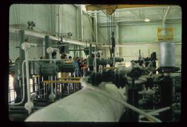
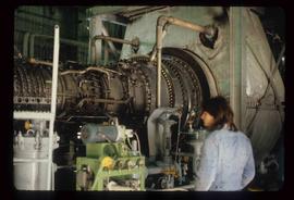
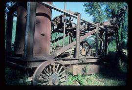
Image depicts what appears to be a small mill in the community of Crescent Spur, B.C.
Image depicts the entrance to the Upper Fraser mill yard in Upper Fraser, B.C. Map coordinates 54°07'10.8"N 121°56'51.7"W
Image depicts the Upper Fraser mill yard with a CN train in Upper Fraser, B.C. Map coordinates 54°07'10.8"N 121°56'51.7"W
Image depicts a view of a saw mill in Chetwynd, B.C.
Image depicts what appears to be a saw mill belonging to Northwood. The location is uncertain.
Image depicts the Lakeland Sawmill in Prince George, B.C, identified by the beehive burners; the one with white smoke belonged to Pas Lumber Co. which was bought out by Lakeland in 1987.
Image depicts the Lakeland Sawmill in Prince George, B.C.
Image depicts Prince George Sawmill taken from across the Nechako River looking southwest. Map coordinates 53°56'00.0"N 122°44'29.7"W
Image depicts industrial machinery in an uncertain location near McLeod Lake, B.C.
Image depicts a piece of industrial machinery in an uncertain location near McLeod Lake, B.C.
Image depicts two mills; the Intercontinental Pulpmill is on the left side of the tracks in the image and the Prince George Pulp and Paper Mill is located on the right side in Prince George, B.C. The Northwood Pulp Mill can be seen in the distance.
Image depicts Prince George from University Way, with the P.G.I. Pulp Mill in the distance.
Image depicts a sawmill in the Danson Industrial Park in Prince George, B.C.
Image depicts an aerial view of the Ahbau area somewhere near Prince George, B.C.
Image depicts a train carrying logs somewhere in Prince George, B.c.
Image depicts a logging area somewhere near Prince George, B.C.
Image depicts a tractor with a claw lifting logs at a saw mill in Prince George, B.C.
Image depicts numerous logs that have been stripped of their bark at a saw mill in Prince George, B.C.
Image depicts machinery stripping a log of its bark in a saw mill somewhere in Prince George, B.C.
Image depicts an unidentified individual examining a piece of heavy machinery used in the forestry industry. It is located in Prince George, B.C.
Image depicts a loading truck at the Gibraltar mine site north of Williams Lake, B.C.
Image depicts an unknown woman standing in front of a truck that either weighs 80 tonnes, or is capable of carrying that much; the slide is simply labelled "80 tons." It is located at the Gibraltar mine site.
Image depicts a large, electric shovel at a mine site somewhere in Granisle, B.C.
Image depicts the BC Packers Ltd. cannery in Prince Rupert, B.C.
Image depicts a large, old piece of machinery, possibly some form of mining or prospecting equipment; it is located in Quesnelle Forks, B.C.
Image depicts the inside of a mine with an unknown individual present. It is possibly the inside of the closed Britannia Mine.
Image depicts a number of old buildings, possibly located at the closed Britannia Mine.
File contains slides depicting Premier Mine in Hyder, Alaska.
Image depicts a Beehive Burner along the Nechako on River Road. Map coordinates 53°55'34.1"N 122°44'58.0"W
Image depicts a logging area somewhere near Prince George, B.C.
Image depicts a saw cutting a log in half at a saw mill in Prince George, B.C.
Image depicts a large saw at an indoor location, likely in a saw mill somewhere in Prince George, B.C.
Image depicts the interior of a saw mill somewhere in Prince George, B.C.
Image depicts two unidentified individuals examining a thick log still attached to the machine that cut it down. It is located somewhere in Prince George, B.C.
Image depicts several pieces of heavy machinery used in forestry. The Coast Inn of the North is seen in the background.
Image depicts a piece of heavy machinery lifting numerous logs off the back of a logging truck. It is likely located in Prince George, B.C.
Image depicts the entrance to a mine with an unknown individual present. It is possibly the entrance to the closed Britannia Mine in the Howe Sound Region.
Image depicts a conveyor belt, possibly located inside one of the old buildings at what is possibly the closed Britannia Mine.
Image depicts a piece of industrial machinery, possibly located at the closed Britannia Mine. Two unknown individuals are also present in the image.
Image depicts the Lajoie hydroelectric generating station at the Lajoie Dam on the Bridge River (view of powerhouse and tailrace from top of dam).
Image depicts what is possibly an old, rundown mill in Bralorne, B.C.
Image depicts the old sales office of Bralorne Pioneer Mines Ltd. which is now the Bralorne Pioneer Museum.
Image depicts the Northwood pulpmill in Prince George B.C.
Image depicts Prince George, possibly with the Northwood Pulpmill in the background.
Image depicts a sawmill, possibly Lakeland Sawmill, in Prince George B.C.
Image depicts a pulpmill, likely Northwood, in Prince George, B.C.
Image depicts the Prince George Sawmill from the Northwood Bridge.
Image depicts two mills; the Intercontinental Pulp Mill is on the right in the foreground, and the Prince George Pulp and Paper Mill is on the left in the background. The picture is taken from the South, possibly off Yellowhead Bridge in Prince George, B.C.