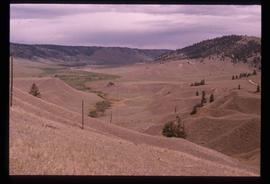
Image depicts what is possibly Atlin Lake, with numerous mountains in the distance and Atlin Mountain visible on the right of the image.
Image depicts the grave of John Wolters in the Atlin Cemetery. It reads: "Born in Kent, England, Jan 16 1857. Died Sept. 21 1905."
Image depicts a river in the Miles Canyon near Whitehorse Y.T.
Image depicts a river in the Miles Canyon near Whitehorse Y.T. The Robert Lowe Bridge, built in 1922, can be seen over the canyon.
Image depicts a lake and a cabin at an uncertain location.
Image depicts a bear, possibly a grizzly. The location is uncertain.
File contains slides depicting the Writing on Stone Provincial Park in Alberta.
Image depicts two merging railway tracks, and what appears to be a frozen river, somewhere near the summit of a mountain.
Image depicts a view over a forested, mountainous area and a river towards the vicinity of Skagway, Alaska.
Image depicts a grave somewhere along the White Pass railway.
File contains slides depicting places in California, USA.
File contains slides depicting Premier Mine in Hyder, Alaska.
File contains slides depicting places in and around Yellowstone and the Snake Plain in the USA.
File contains slides depicting closeups of flowers at unknown locations.
Image depicts the cableway in Willow River, B.C.
Image depicts a logging area somewhere near Prince George, B.C.
Image depicts a saw cutting a log in half at a saw mill in Prince George, B.C.
Image depicts two unidentified individuals examining a thick log still attached to the machine that cut it down. It is located somewhere in Prince George, B.C.
Image depicts a piece of heavy machinery lifting numerous logs off the back of a logging truck. It is likely located in Prince George, B.C.
Image depicts a small slope on Carney Hill in Prince George, B.C.
Image depicts miocene gravels on Carney Hill in Prince George, B.C.
Image depicts an aerial view of a grooved region of land at an uncertain location.
Image depicts an example of varves, an annual layer of sediment or rock, with a pipe used for reference size. It is possibly located at the airport in Prince George, B.C.
Image depicts sand beds with a shovel present for size reference. The slide places it at the "BCR site," possibly in Prince George, B.C.
Image depicts grooving on Tabor Mountain in Prince George, B.C.
Image depicts grooves on Tabor Mountain in Prince George, B.C.
File contains slides depicting physical landscape features at various locations, most are from outside Northern B.C.
Image depicts the slopes of Tabor Mountain in Prince George, B.C.
Image depicts numerous skiers on the Birchleg Ski route on Tabor Mountain in Prince George, B.C.
Image depicts numerous skiers cross-country skiing on a trail through trees on the Birchleg Ski route on Tabor Mountain in Prince George, B.C.
Image depicts a view of the area around Tabor Mountain in Prince George, B.C.
Image depicts numerous skiers and skis that are standing upright in in the snow on Tabor Mountain in Prince George, B.C.
Image depicts a view of the landscape surrounding Tabor Mountain in Prince George, B.C.
Image depicts an unidentified man cross country skiing somewhere on Tabor Mountain in Prince George, B.C.
File contains slides depicting vegetation and a few maps.
File contains slides depicting the opening of the Cottonwood Park section of the Heritage River Trails in Prince George, B.C.
Image depicts a large crowd of people on a section of the Heritage Trail on Cottonwood Island in Prince George, B.C.
Image depicts a crowd of people in Cottonwood Park in Prince George, B.C.
Image depicts a view of the eastern part of the upper Fraser Canyon.
Image depicts the Fraser River passing through the upper Fraser Canyon.
Image depicts the Upper Fraser Canyon from what appears to be the entrance to Gang Ranch.
Image depicts a road near or on Gang Ranch in the Upper Fraser Canyon.
Image depicts the Fraser River near Gang Ranch in the Upper Fraser Canyon.
Image depicts a bridge over the Fraser River in the Upper Fraser Canyon; possibly near Gang Ranch.
Image depicts a view of the Upper Fraser Canyon.
Image depicts a view of some of the scenery near the Upper Fraser Canyon.
Image depicts the Alkali Lake Ranch in Alkali Lake, B.C.