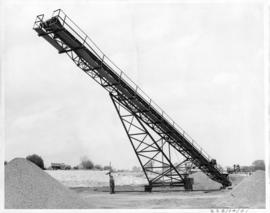
Photograph of dry rock storage of Nordenhem Finishing Mill in Germany. Part of Visitation Report.
Photograph of outside of tailing bins at Nordenham Germany. Part of Trip Report.
Photograph of outside of dry rock storage building in Nordenham Germany. Part of Visitation Report.
Photograph of automatic recorder from front angle. Part of trip report to Nordenham Finishing Mill.
Photograph of automatic recorder from back angle. Part of trip report to Nordenham Finishing Mill in Germany.
Photograph of shrink wrap machine at Nordenham Finishing Mill, Germany. Part of Cassiar trip report.
Photograph of automatic sewing machines at Nordenham Finishing Mill in Germany. Depicts an unidentified man in foreground to right. Part of trip report.
Photograph of bagging rams inside Nordenham Finishing Mill in Germany. Part of trip report.
Photograph of dust collect bays, with unidentified man in background, at Nordenham Finishing Mill in Germany. Part of trip report.
Photograph of cyclone blockage detector at Nordenham Finishing Mill in Germany. Part of trip report.
Photograph depicts an unidentified man engaged in the bagging process at Nordenham Finishing Mill in Germany. Part of trip report.
Photograph of automatic sewing machine. There is an unidentified man in the foreground to the right. Part of trip report to Nordenham Finishing Mill Germany.
Photograph of rotex screen covers at Nordenham Finishing Mill in Germany. Part of trip report.
Photograph of plastic inserts from Nordenham Finishing Mill in Germany. Part of trip report.
Photograph of plastic inserts at Nordenham Finishing Mill in Germany. Part of trip report.
Photograph of rotex screen at Nordenham Finishing Mill in Germany. Part of trip report.
Photograph of automatic bag weigh system at Nordenham Finishing Mill in Germany. Part of trip report.
Photograph of deduster screen cleaner at Nordenham Finishing Mill in Germany. Part of trip report.
Operator loading Asbestos into feeder at Welshpool Asbestos Mill in Australia.
Side view of the wet end of mazza machine.
This photograph is an aerial depiction of what is believed to be a Certain Teed factory in the United States. Certain Creed is a manufacturing company that supplies building materials. They have been in operation since 1904 to present. This photograph was found along with invoices, shipping orders and correspondence between Certain Teed and Cassiar.
Photograph depicts man believed to be Matt Bell standing in Kutcho Creek exploration camp. The camp was set up by a crew led by Cassiar's Chief Geologist Bill Plumb. Tents on either side, wood structure in background. Sign on wood post: "PLUMB BLVD."
Photograph believed to have been taken near Kutcho Creek, BC during an outside exploration trip led by Cassiar's Chief Geologist Bill Plumb. Bill stands to left of man believed to be Matt Bell in right foreground. Bulldozer works along talus slope in left foreground.
Photograph depicts valley in Kutcho Creek area, exploration camp in distance at foot of hill. The camp was set up by a crew led by Cassiar's Chief Geologist Bill Plumb.
Bulldozer works along talus slope in centre of image. Photograph believed to have been taken near Kutcho Creek, BC during an outside exploration trip led by Cassiar's Chief Geologist Bill Plumb.
Photograph depicts valley in Kutcho Creek area, exploration camp in distance. Body of water in foreground, mountains in background. The camp was set up by a crew led by Chief Geologist Bill Plumb.
Photograph depicts a valley in the Kutcho Creek area with an exploration camp in the distance at the foot of a hill. The camp was set up by a crew led by Cassiar's Chief Geologist Bill Plumb.
Photograph depicts an exploration camp in the valley at the Kutcho Creek area in B.C. The camp was set up by a crew led by Cassiar's Chief Geologist Bill Plumb.
Photograph depicts steel drums and wooden buildings at an exploration camp in the Kutcho Creek valley area of B.C. The camp was set up by a crew led by Cassiar's Chief Geologist Bill Plumb. An arrow points to a possible burial site.
Photograph depicts George Edzerza , R. T. Gilman, Bill Mossoh, and Pete Hamlin with gear and wearing snowshoes in the Asbestos Mountain area. It is believed that the photograph portrays their exploration of the future mine at Cassiar.
Photograph depicts three men on Asbestos Mountain who are believed to be members of George Edzerza's expedition party during an exploration of the future mine at Cassiar.
Handwritten annotation on verso in blue ink describing sections of photograph which have been pointed to or outlined in blue ink: "LOOKING SOUTH" "ORE ZONE <500' [?] >" "'FLUFF' AREA" "2 MEN" "1 MAN" "OVER -->"
Handwritten annotation on recto in blue ink: "The shaded areas do not indicate 'fluff' necessarily - They are shadows from mountains. The size of the men will give you some indication of the distance".
Photograph depicts steel drums and wooden buildings at an exploration camp in the Kutcho Creek valley area of B.C. The camp was set up by a crew led by Cassiar's Chief Geologist Bill Plumb.
Photograph depicts the dogsled team of George Edzerza's expedition party on Asbestos Mountain during an exploration of the future mine at Cassiar.
Photograph depicts three men on Asbestos Mountain who are believed to be members of George Edzerza's expedition party during an exploration of the future mine at Cassiar.
Photograph depicts the projected mining area of Asbestos Mountain, taken during the expedition of George Edzerza's party and their exploration of the future mine at Cassiar.
Handwritten annotations on verso in blue ink describing sections of photograph which have been pointed to or outlined in blue ink: "PROJECTED STRIKE - LOOKING NORTH - OVER -->" "<500'>" "NORTH".
Handwritten annotations in black ink on verso also outline areas and mark areas with "x".
Handwritten annotation on recto in blue ink: "No. 2. This is the continuation of the ore zone, over the top of the mountain, away from the 'fluff'' deposit."
Photograph depicts the projected mining area of Asbestos Mountain, taken during the expedition of George Edzerza's party and their exploration of the future mine at Cassiar.
Photograph depicts a dirt road 6 miles from the Alaska Highway.
Photograph depicts a bridge at Blue River taken from shore.
Photograph depicts the projected mining area of Asbestos Mountain, taken during the expedition of George Edzerza's party and their exploration of the future mine at Cassiar.
Handwritten annotation on verso in blue ink describing sections of photograph which have been pointed to or outlined in blue ink: "LOOKING SOUTH" "ORE ZONE <--500'--> ORE IN PLACE" "FLUFF AREA" "SOUTH^".
Photograph depicts a truck on a newly cleared dirt road in a mountain pass and a wooded area.
Photograph depicts a wooden structure in a gravel landscape. Truck with open door in foreground, forest and snow capped mountains in background. Mounds of gravel visible behind structure.
Photograph depicts a log bridge across Quartz Creek taken from shore. Trees in background on opposite shore, snow capped mountains barely visible behind trees.
Photograph depicts three small camp structures in dirt landscape: one trailer, one wooden building and one tent building. Logs and wood pile in foreground, forest and snow-capped mountain in background.
Photograph depicts a dirt roadway in wooded area. Snow capped mountains in background.
Photograph depicts a pile of industrial material in a wooded area. Pile includes what is believed to be cardboard boxes and lumber planks. Trees in background, mountains barely visible behind trees.