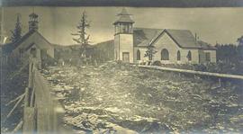
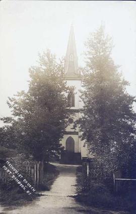
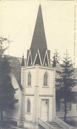
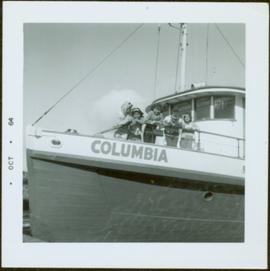
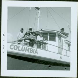
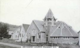
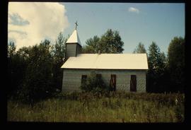
Photograph depicts a brick Methodist church on a street beside houses. Annotation on recto of photograph states: "METHODIST CHURCH, ENDERBY, B.C."
Photograph depicts a church and unidentified building with a large fenced yard in the foreground. Annotation on verso of photograph states: "Bella Bella Church"
Photograph depicts the interior of an unidentified church with a view of the central altar and pipe organ.
Photograph depicts the interior of an unidentified church decorated with tree boughs and a star.
Photograph depicts several buildings along a forested shoreline with a church in the background.
Photograph depicts the interior of a church decorated with white streamers. Annotation on verso states: "Canada, B.C., Indian(?) Bella Bella Church decorated for Christmas by Indian "decoration""
Photograph depicts several houses and headstones built on a rocky shoreline with water in the foreground. Annotation on verso of photograph states: "Canada, B.C. Bella Bella - Indian Missions. Indian Grave houses and monuments"
Photograph depicts a group of nine men holding a flag and banner that states: "The Epworth League of The Methodist Church of Canada." Annotation on verso of photograph states: "Epworth League Officers Port Simpson This is a fair sample of the "shots" I made"
Photograph depicts a group of First Nations girls posed for a photo with two women on what appears to be a boat. Possibly a Mission School class photo.
Photograph of the interior of an unidentified church with a view of the central altar.
Photograph depicts the exterior of an unidentified church with a steeple.
Photograph depicts a group of First Nations boys with a minister posed for a photo on what appears to be a boat. Possibly a Mission School class photo.
Photograph depicts the exterior of a church with a steeple surrounded by trees. Annotation on recto of photograph states: "Methodist Church Port Simpson BC"
Photograph depicts a steeple on the side of a church. Annotation on recto of photograph states: "English Church, Port Essington, B.C."
Photograph depicts an unmarked First Nations gravesite featuring two crosses at Moberly Lake.
Photograph depicts a fishing camp with boats and buildings on floating docks and a forested environment visible in the background. Handwritten annotation on verso states: “1960 Seymour Inlet. Oscar Johnston’s Camp on the Move. Taken from Mission Ship Columbia”; photographer’s stamp on verso states: “W.E. Nicholson”
Photograph depicts an unidentified priest and man standing in the doorway as a small house under construction.
Photograph depicts five First Nations children leaning over the deck on the M.S. Columbia. Stamped annotation on recto: “Oct – 64”. Handwritten annotation in pen on verso reads: “Mamalicula”
Photograph depicts five First Nations children and a ship captain on the deck of the M.S. Columbia. Stamped annotation on recto states: “Oct – 64”
Photograph features interior perspective of the front of an Anglican church as seen from the nave. A large stained glass window, a carved Thuderbird lecturn and the altar are visible.
Image depicts a church located near Mapes, B.C.
Image depicts a church at an uncertain location.
Image depicts an old Anglican Church in Barkerville, B.C.
Image depicts the interior of a church, possibly one in or near Barkerville, B.C.
Photograph depicts three Anglican priests that served Nisga’a communities in the Nass Valley of British Columbia. They have been identified as (left to right): Father John Hannen (serving Gingolx, later Bishop of the Anglican Diocese of Caledonia), Father John Blyth (serving Gitlaxt'aamiks), and Father David Retter (serving Laxgalts'ap).
Image depicts a church school in the community of Crescent Spur, B.C.
Image depicts an open field and numerous buildings, including a church in Giscome, B.C. Map coordinates 54°04'03.2"N 122°22'04.6"W
Image depicts the Oblates of Mary Immaculate Catholic Church in Aleza Lake, B.C. Map coordinates 54°07'08.2"N 122°02'00.0"W
Image depicts a church in Giscome, B.C. Map coordinates 54°04'16.2"N 122°21'54.3"W
Image depicts several unidentified individuals inside of a church made from logs, possibly located in Fort St. John, B.C.
Image depicts a church in Wells, B.C.
Image depicts a row of houses, as well as a United Church of Canada on the right side of the image, located in Wells, B.C.
Image depicts an Anglican church in Kitwancool Lake, B.C.
Image depicts a Catholic Church on Stoney Creek Road in Vanderhoof, B.C.
Image depicts a church on a hill in Hagwilget, B.C.
Image depicts a church on a hill in Moricetown, B.C.
Image depicts an Anglican church and a bell tower in Kitwanga.
Image depicts several unidentified individuals exiting a church made of logs, possibly in Fort St. John, B.C.
Image depicts St. Peter's Church in Mackenzie, B.C.
Image depicts a Catholic Church in Dome Creek, B.C.
Image depicts St. Peter's Church in Mackenzie, B.C.
Image depicts the St. Marks Community Church in Stewart, B.C.
Image depicts a Catholic Church in Stewart, B.C.
Image depicts a church, somewhere between Hazelton and Hagwilget, B.C.
Image depicts the interior of the St. Marks Community Church in Stewart, B.C.
Image depicts a church and several other buildings in Canoe Creek.
Image depicts a church and a row of houses in Bralorne, B.C.
Image depicts the Catholic Church in Penny, B.C.
Image depicts St. Mark's Anglican Church in Woodpecker, B.C.