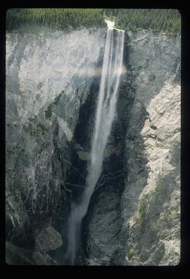
Showing 1985 results

Archival description
1985 results with digital objects Show results with digital objects
Valemount - Reservoir
2012.13.1.85.24 · Item · [1976?]
Part of J. Kent Sedgwick fonds

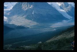
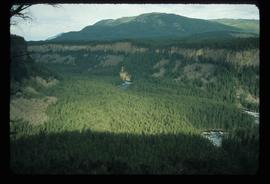
Image depicts a distant view of what appears to be a body of water, with numerous mountains in the background. The slide is labelled "Valemount reservoir."

Valley
2012.13.1.56.57 · Item · 1973
Part of J. Kent Sedgwick fonds

Image depicts a view of a small valley in Mt. Robson Provincial Park.

Valley?
2012.13.1.59.13 · Item · July 1980
Part of J. Kent Sedgwick fonds

Image depicts a river running through a valley-like area somewhere near Bralorne, B.C.

Varves
2012.13.1.124.16 · Item · Oct. 1975
Part of J. Kent Sedgwick fonds

Image depicts an example of varves, an annual layer of sediment or rock, with a pipe used for reference size. It is possibly located at the airport in Prince George, B.C.

Varves
2012.13.1.124.15 · Item · Oct. 1975
Part of J. Kent Sedgwick fonds

Image depicts an example of varves, an annual layer of sediment or rock, possibly located at the airport in Prince George, B.C.

View from Gunn Point
2012.13.1.3.060 · Item · Nov. 1979
Part of J. Kent Sedgwick fonds

Image depicts a view of Prince George from Gunn Point in the L.C. Gunn Park looking north. Map coordinates 53°54'26.2"N 122°43'35.8"W.

View from Gunn Point
2012.13.1.3.061 · Item · Nov. 1979
Part of J. Kent Sedgwick fonds

Image depicts a view of Prince George from Gunn Point in the L.C. Gunn Park looking north. Map coordinates 53°54'26.2"N 122°43'35.8"W.

View from Gunn Point
2012.13.1.3.059 · Item · Nov. 1979
Part of J. Kent Sedgwick fonds

Image depicts a view of Prince George from Gunn Point in the L.C. Gunn Park looking north. Map coordinates 53°54'26.2"N 122°43'35.8"W.

View from Gunn Point
2012.13.1.3.064 · Item · Nov. 1979
Part of J. Kent Sedgwick fonds

Image depicts a view of Prince George from Gunn Point in the L.C. Gunn Park looking north. Map coordinates 53°54'26.2"N 122°43'35.8"W.

View from Gunn Point
2012.13.1.3.065 · Item · Nov. 1979
Part of J. Kent Sedgwick fonds

Image depicts a view of Prince George from Gunn Point in the L.C. Gunn Park looking north. Map coordinates 53°54'26.2"N 122°43'35.8"W.

View from Gunn Point
2012.13.1.3.058 · Item · Nov. 1979
Part of J. Kent Sedgwick fonds

Image depicts a view of Prince George from Gunn Point in the L.C. Gunn Park looking north. Map coordinates 53°54'26.2"N 122°43'35.8"W.

View from Gunn Point
2012.13.1.3.062 · Item · Nov. 1979
Part of J. Kent Sedgwick fonds

Image depicts a view of Prince George from Gunn Point in the L.C. Gunn Park looking north. Map coordinates 53°54'26.2"N 122°43'35.8"W.

View from Gunn Point
2012.13.1.3.063 · Item · Nov. 1979
Part of J. Kent Sedgwick fonds

Image depicts a view of Prince George from Gunn Point in the L.C. Gunn Park looking north. Map coordinates 53°54'26.2"N 122°43'35.8"W.

View from Gunn Point
2012.13.1.3.066 · Item · Nov. 1979
Part of J. Kent Sedgwick fonds

Image depicts a view of Prince George from Gunn Point in the L.C. Gunn Park looking north. Map coordinates 53°54'26.2"N 122°43'35.8"W.

View from Gunn Point
2012.13.1.3.067 · Item · Nov. 1979
Part of J. Kent Sedgwick fonds

Image depicts a view of Prince George from Gunn Point in the L.C. Gunn Park looking north. Map coordinates 53°54'26.2"N 122°43'35.8"W.

View of Pine Pass
2012.13.1.93.55 · Item · 1978
Part of J. Kent Sedgwick fonds

Image depicts a view of Pine Pass on the border between Alberta and British Columbia in the Rocky Mountains.

View South - Trees
2012.13.1.41.23 · Item · 2002
Part of J. Kent Sedgwick fonds

Image depicts a view south, possibly of an abandoned grade for the BCR; possibly somewhere near Woodpecker, B.C.

W.A.C. Bennett Dam
2012.13.1.91.02 · Item · Sep. 1974
Part of J. Kent Sedgwick fonds

Image depicts a section of the Peace River blocked off by the W.A.C. Bennett Dam. The dam itself is not visible in the image.

Waterfall
2012.13.1.56.12 · Item · 1973
Part of J. Kent Sedgwick fonds

Image depicts a waterfall on a mountain side in Mt. Robson Provincial Park.

Waterfall
2012.13.1.46.40 · Item · 1980
Part of J. Kent Sedgwick fonds

Image depicts a waterfall somewhere in South Tweedsmuir Provincial Park.

Waterfall
2012.13.1.46.17 · Item · 1980
Part of J. Kent Sedgwick fonds

Image depicts an aerial view of a waterfall in South Tweedsmuir Provincial Park.

Waterfall
2012.13.1.46.16 · Item · 1980
Part of J. Kent Sedgwick fonds

Image depicts an aerial view of a waterfall in South Tweedsmuir Provincial Park.

Waterfall
2012.13.1.46.19 · Item · 1980
Part of J. Kent Sedgwick fonds

Image depicts an aerial view of a waterfall in South Tweedsmuir Provincial Park.

Wells Hospital building
2012.13.1.37.23 · Item · 1978
Part of J. Kent Sedgwick fonds

Photograph depicts the old hospital building in Wells. At the time the photo was taken, 1978, it was being used as an apartment building, and that is still its current use.

White Pass - Mountain Side
2012.13.1.100.12 · Item · 1999
Part of J. Kent Sedgwick fonds

Image depicts a mountain side somewhere along the White Pass railway. The thin ridge along the mountain side is possibly either a highway or part of the railway.

White Pass - Mountain Side
2012.13.1.100.11 · Item · 1999
Part of J. Kent Sedgwick fonds

Image depicts a mountain side somewhere along the White Pass railway. The thin ridge along the mountain side is possibly either a highway or part of the railway.