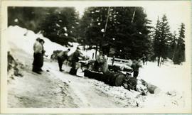
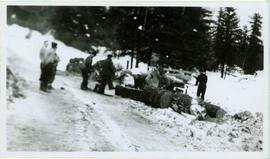
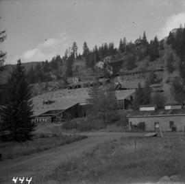
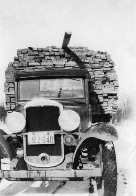
Print preview Close

Showing 971 results

Archival description
971 results with digital objects Show results with digital objects
2009.5.2.51 · Item · [ca. 1910?]
Part of Taylor-Baxter Family Photograph Collection

Photograph depicts two log buildings in fenced area on lake shore, forest trees in background. A man can be seen standing near docking area and small boat pier extending into water in foreground. Handwritten annotation on recto of photograph: "Fur Farm Red Rock Lake". This location is believed to at mile 27, north of Summit Lake.

Gibraltar - 80 Tonne Truck
2012.13.1.50.094 · Item · [1978?]
Part of J. Kent Sedgwick fonds

Image depicts an unknown woman standing in front of a truck that either weighs 80 tonnes, or is capable of carrying that much; the slide is simply labelled "80 tons." It is located at the Gibraltar mine site.

Giscome - Power Poles
2012.13.1.87.098 · Item · [between 1975 and 1995]
Part of J. Kent Sedgwick fonds

Image depicts the remains of a street of houses in Giscome, B.C. The quarry is slightly visible in the background. Map coordinates 54°04'20.9"N 122°21'53.1"W

2012.13.1.87.086 · Item · [between 1980 and 2000]
Part of J. Kent Sedgwick fonds

Image depicts the Giscome mill site in Giscome, B.C. The bunkhouse is the large building with many windows. A train and railroad tracks are in the foreground. Map coordinates 54°04'17.6"N 122°22'06.1"W

Giscome Sawmill
2012.13.1.87.167 · Item · [between 1975 and 1995]
Part of J. Kent Sedgwick fonds

Image depicts the mill site at Giscome, B.C. Map coordinates 54°04'19.7"N 122°22'04.7"W

Giscome Sawmill
2012.13.1.87.171 · Item · [between 1975 and 1995]
Part of J. Kent Sedgwick fonds

Image depicts the mill site at Giscome, B.C. A sign in the foreground reads "Maynard's Industrial Auctioneers." Map coordinates 54°04'19.7"N 122°22'04.7"W

Giscome Sawmill
2012.13.1.87.168 · Item · [between 1975 and 1995]
Part of J. Kent Sedgwick fonds

Image depicts the mill site at Giscome, B.C. Map coordinates 54°04'19.7"N 122°22'04.7"W

Giscome Sawmill
2012.13.1.87.170 · Item · [between 1975 and 1995]
Part of J. Kent Sedgwick fonds

Image depicts the mill site at Giscome, B.C. Map coordinates 54°04'19.7"N 122°22'04.7"W

Giscome Sawmill
2012.13.1.87.169 · Item · [between 1975 and 1995]
Part of J. Kent Sedgwick fonds

Image depicts the mill site at Giscome and its beehive burner. Map coordinates 54°04'19.7"N 122°22'04.7"W

Gravel Pit
2000.1.1.3.18.013 · Item · June 1987
Part of Cassiar Asbestos Corporation Ltd. fonds

Photograph depicts close up view of gravel pit, ruler displayed for scale. Photograph speculated to have been taken at the plant or near the Cassiar airstrip. Stamped annotation on recto of photograph: "JUN. 1987".

Grizzly Bear
2005.3.52 · Item · [ca. 1945]
Part of John Hart Highway Photograph Collection

Handwritten caption below this photo reads: "Bought in Picture Prince George". Photograph depicts a grizzly bear walking on all fours in forest area, slash debris in background.

2009.7.1.268 · Item · 28 September 1920
Part of Archdeacon W. H. Collison fonds

Photograph of a partially sunken sailboat near a harbour. Individuals on debris and in a rowboat are surveying the damage. Annotation on recto reads: "GTP. SS Prince Rupert Sept 28th 1920 McRae." Handwritten annotation on verso reads "CTP "Prince Rupert" Sunk at Prince Rupert BC 1920."

2011.3.1.02 · Item · [ca. 1905]
Part of North Coast & Central BC Postcard Collection

View of building, dock, harbour and small islands with snow peaked mountains in background. Printed caption on verso reads: “Port Essington B.C. Photo by P. E. Fisher”. Handwritten annotation in ink on verso reads: “up the Skeena”, in pencil on verso: “Port Essington, North Coast Commercial Coy”.

2005.3.63 · Item · [ca. 1946]
Part of John Hart Highway Photograph Collection

Handwritten annotation on recto of photo reads: "Harry Monson Edmonton Prince George." Harry reclines on bed under window, surrounded by personal effects. Photograph was taken after nightfall. Handwritten caption beside this photo reads: "Harry talked my dad into selling him my boat".

2000.1.1.3.19.101 · Item · [ca. 1975]
Part of Cassiar Asbestos Corporation Ltd. fonds

Photograph depicts the West Peak of the Cassiar mine on McDame Mountain. Pit area visible between West Peak and road in foreground. Mine valley and north mountain range in background. Photo speculated to have been taken from a point on or near the South or North Peak.

2009.7.1.133 · Item · [ca. 1910?]
Part of Archdeacon W. H. Collison fonds

Photographs depict groups of men gathered on ice. Herbert leans over behind two friends seated on ice sled (son of Marion and Archdeacon W.H. Collison). Pile of caught fish can be seen in foreground behind large whole in ice.

Handwritten annotations on verso read: "Oolichan Fishing Fishing Bay Nass River"; "Uncle Herbert with Indian friends fishing for oolichan through the ice."

2011.3.3.20 · Item · [ca. 1910]
Part of North Coast & Central BC Postcard Collection

View of fish boat in water, with net spread and smaller boat on opposing side of net. Several gulls can be seen flying in the air. Rail cars town and treed hills in background. Printed annotation on recto reads: “Herring Fishing In Prince Rupert Harbour McRae Bros.” Handwritten message in ink on verso is addressed to “Mr. H. Smart 2550 Blackwood St. Victoria B.C.”