File consists of a speech given by Gary Runka entitled "Vegetable Situation in BC".
File consists of crown land plan for Vanderhoof by the Province of BC's Ministry of Lands, Parks, and Housing.
File consists of notes and reproductions relating to the Vanderhoof and area townsites. Also includes a map depicting the South Hazelton townsite before 1980.
File consists of notes and reproductions relating to Vanderhoof and area.
Item is a map depicting land use in the Vancouver Carney study neighbourhood area in Prince George. Also includes two mylar overlays that show the outlines of "unit 2" and "unit 3" development areas.
Item is a map depicting the Vancouver Carney study neighbourhood area in Prince George.
This CD-ROM contains the digital publication, "Vancouver and Fraser Valley Orthophotos on CD-ROM". Software install on a compatible computer is required to access the content.
Item is a hand drawn and coloured map by the City of Prince George Planning Department depicting existing zoning for the Van Bow neighbourhood area. Also includes two hand-drawn mylar overlays for the map; one showing "Opportunities & Constraints" such as housing age and condition and the other showing "Subdivision Activity" over decades of development in the Van Bow area.
Item is a hand drawn and coloured map by the City of Prince George Planning Department depicting existing land use for the Van Bow neighbourhood area.
Item is a hand drawn and coloured map by the City of Prince George Planning Department depicting existing land use for the Van Bow neighbourhood area.
Item is an original bound copy of "Use and Management of Land on Valley Train Deposits", Gary Runka's 1968 thesis presented to the Faculty of the Graduate School of Cornell University for the Degree of Master of Science.
File consists of a brief developed by the Lower Mainland Regional Planning Board of B.C. examining the problems with expanding urban sprawl in Greater Vancouver, outlining the findings of the research, and offering future suggestions.
File consists of the preliminary outline of an urban pattern study by N. Pearson. Appended to the beginning of the report, members of the technical committee have laid out points of constructive critisicm about the drafted report. Includes a few pages of suggested edits and a drafted report on urban patterns.
File consists of a speech given by Gary Runka entitled "Urban Growth Impact on Rangelands in British Columbia" for the Society for Range Management - Pacific Northwest Section in Spokane, Washington.
Commentary on this speech by Barry Smith of the Ministry of Agriculture and Lands:
"In this speech GGR focuses on a single example of the Lauder Ranches at Glimpse Lake (north east of Merritt and about 12 km north of Douglas Lake) and states that his perspective for the purpose of his presentation is to look through the eyes of one that perceives the utilization of the forage resource to best advantage is for red meat production as opposed to the view of the urban planner.
In this example it appears the "urban" land use is a proposal to subdivide land along the lake shore for residential / recreation purposes.
GGR outlines the potential impacts on the long standing ranching operation. In his summary he mentions his concern with regard to recent changes to the (now) Agricultural Land Commission Act in stating, "...I think recent amendments to the Agricultural Land Commission Act opening appeal of Commission decisions to the political arm is going to cause serious problems (politicians do not understand the impact question)..." This is a reference to the appeal mechanism to ELUC.
There is also an appeal for beef producers to get involved more directly in planning and political processes which is a theme GGR has expressed in previous speeches."
Item is an original copy of the proceedings for the March 1993 symposium "Urban Growth and the Agricultural Land Reserve: Up not Out" organized by the B.C. Agricultural Land Commission. Includes accompanying excerpt of G. Gary Runka's speaking notes for his speech on "Agriculture in the Urban Shadow".
Item is a copy of "Upper Dean River Local Resource Use Plan".
File consists of notes for an untitled speech about "Experiences at the B.C. Land Commission" by Gary Runka at a Habitat 1976 panel at the United Nations Conference on Human Settlements, Vancouver between May 31-June 11,1976.
Commentary on this speech by Barry Smith of the Ministry of Agriculture and Lands:
"GGR gave this speech as part of a panel at Habitat 1976.
The speech outlines the scope of the legislation, background of a provincial zoning technique (based on technical information), the establishment of the ALR plans in each of 28 regional districts and commentary on some of the projects the Commission is involved with.
Providing context to the land-use planning environment that the B.C. farmland preservation program and ALR were thrust into in the mid-1970s, GGR remarks that:
"In many cases we have local governments making their first real strong attempt at land use planning. Backed by the strength of the Land Commission Act it is seen as a real change to control urban sprawl and linear development that is detrimental from other planning points of view, as well as from the agricultural land point of view."
The fact that GGR was asked to be part of the panel at the first United Nations Conference on Human Settlements speaks to the regard given the B.C. farmland preservation program."
File consists of an untitled speech about resource conflicts given by Gary Runka to the Society Promoting Environmental Conservation (SPEC) Annual General Meeting in Vancouver.
Commentary on this speech by Barry Smith of the Ministry of Agriculture and Lands:
"The original version consists of 3 pages of hand-written notes that were accompanied by slides (not available). The hand written notes have been transcribed.
GGR outlined several societal needs and wants but emphasises that we don't have enough land to provide for all these needs and desires if we keep planning in a haphazard manner.
He urges environmentalists to be prepared technically and avoid the image of being opposed to everything. He calls for greater integration in dealing with resource issues.
GGR was the keynote, guest speaker at the meeting."
File consists of an untitled speech to the Chilliwack Chamber of Commerce regarding land use planning and its impact on the food producer.
Commentary on this speech by Barry Smith of the Ministry of Agriculture and Lands:
"These 3 pages of notes prepared for a speech given to the Chilliwack Chamber of Commerce are packed with several important themes and is a more refined version of [2020.4.2.1.24].
Some of the important themes mentioned include:
- Preserving the option of agriculture in BC will not be accomplished by preserving agricultural land alone;
- Prior to the ALR we were losing our best farmland first;
- BC is attempting to become more self-sufficient in food production;
- BC agriculture is diverse but lacks large volumes of any single commodity;
- Rural areas must be carefully planned to protect food production and not thought of as a storehouse of future urban development;
- With land use planning it is often difficult to see benefits in the short term but losses for a few people should amount to long term gains for many; and
- Several examples are provided of initiatives aimed at protecting rural areas, habitat etc.
The speech notes include the first mention of the work of the Ministry of Agriculture's Greenzone Committee and its efforts to find ways of reducing land use conflicts.
Many of these themes have been considered in previous speeches but are consolidated here and the paper ends with a need for food producers to get involved in land use planning process."
File consists of an untitled published piece in Country Life Column by Gary Runka.
Commentary by Barry Smith of the Ministry of Agriculture and Lands:
"This article is focused on renewed interest in the development of a provincial land use strategy. The article outlines the lack of action for over 20 years in the development of such a strategy.
Several key land and water uses that warrant consideration are listed - starting with agriculture - along with a list of overriding issues.
The position of GGR is clear in the last paragraph - 'The time for a provincial land use strategy was yesterday"..
Although farmland preservation is not specifically identified it would, one would have to think, clearly be one element of a land use strategy."
File consists of an untitled published piece in Country Life Column by Gary Runka.
Commentary by Barry Smith of the Ministry of Agriculture and Lands:
"This article focuses a report of the B.C. Round Table on the Environment and the Economy - "A Better Way - Creating a Sustainable Development Strategy for B.C." published in 1990. The thrust of the article concerns the disregard for agriculture in the report. The report identifies six key principles which amount to reasonable objectives / goals but in contrast agriculture fares badly in the report. Three examples are provided of the report's failings with respect to agriculture. Four key questions are asked including, "How can we best protect the limited high capability agricultural land base from alternate use competition?"
Item is a Universal Soil Loss Equation Calculator slide rule designed by the Soil Conservation Service to calculate water erosion.
File consists of two annual reports, one of the president and one of the executive director, of the Union of BC Municipalities.
Fonds consists of maps, plans, and drawings collected by faculty in the UNBC School of Planning and Sustainability. The majority of these maps reflect the planning history of the City of Prince George and include large format, hand-drawn plans created by the City Planning Department from the 1970s and 1980s. Maps from City of Prince George Official Community Plans are also included.
File consists of G. Gary Runka's UBC academic records.
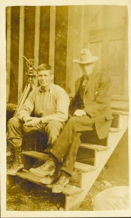
Photograph of two men relaxing on some short exterior stars. A surveying transit can be seen in the background.
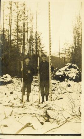
Photograph of two men posing with large surveyor's measuring sticks in a forested area during winter.
Item is a publication entitled "Trumpeter Swans: A Story in Conservation on the Pacific Coast".
File consists of a presentation folder containing the Official Report of Debates of the Legislative Assembly (Hansard) from Wednesday, February 12, 2014 Afternoon Sitting (Volume 5, Number 2) which includes a tribute to Gary Runka. Also includes a DVD.
This CD-ROM contains the digital publication, "Tree Fruit Suitability Digital Atlas: Tree Fruit Suitability in the Okanagan, Similkameen and Creston Valleys". Software install on a compatible computer is required to access the content.
File consists of a traffic planning study by Stanley Associates Engineering Ltd. for the City of Prince George.
File consists of notes and reproductions relating to townsites along the Grand Trunk Pacific Railway. Includes material regarding townsite planning for McBride, Willow River, Prince George, Terrace, Prince Rupert, and South Hazelton.
The item is a reproduction of a survey map drafted in 1909. The reproduction was likely created in 1990. The area covered is South of Fort George Avenue, East of Fraser Street, North of Mount Stephen Avenue, and West of Simpson Street. Annotations state, "Pl. 649."
The item is a reproduction of a survey map drafted in September 1909. The reproduction was likely created in 1990. The annotations highlight owners of different lots up to approximately 1959. Th area covered is North of Fifteenth Avenue, East of Irwin Street, South of Eighth Avenue and West of Carney Street. Annotations on attached papers indicate different means of scale and measurement for the map.
Photograph depicts the town of Lytton in October 1936.
Photograph depicts the town of Hope in October 1936.
Photograph depicts the town of Clinton. Wyness noted on the photograph verso that the survey crew had dinner here on their return trip in October 1936. In addition, the album caption notes that Clinton was the location of British Columbia's oldest hotel.
Item is a photocopied version of "Toward a Marine Protected Areas Strategy for the Pacific Coast of Canada" discussion draft by Province of BC and Government of Canada.
Item is a photocopied version of "Tourism: For Better or For Worse: Taming the Dragons of Growth and Change" speech presented to Regional Tourism Workshops by A. Pollock.
Item is a photocopied version of a draft "Tofino Regional Tourism Study Executive Summary" by Ric Careless.
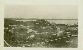
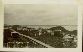
Wide angle photograph showing the intersection of 3rd Avenue and 6th Street, as well as 5th Street in Prince Rupert. Many buildings are visible along the wooden street including a building in mid-construction. Annotation on recto reads: "Prince Rupert, BC. 6th Street 3rd Ave. 5th St Allen Photo Aug 6/09."
Wide angle photograph showing 3rd and 2nd Avenue in Prince Rupert. Many buildings, both commercial and residential, and some tents are situated along the wooden roads. Annotation on recto reads: "Prince Rupert, BC. 3rd Avenue 2nd Avenue Allen Photo Aug 6/09."
Item is a copy of the 1981 "The Vegetation of Burns Bog, Fraser Delta, Southwestern British Columbia" by Hebda, R.J. and W.G. Biggs in Syesis (Vol. 14) published by British Columbia Provincial Museum.
File consists of a contribution to a workshop given by Gary Runka entitled "The Use of Bio-Physical Information - BC Land Commission Overview". Includes excerpts from the Proceedings from the Workshop on Ecological Land Classification in Urban Areas, Canadian Committee on Ecological Land Classification, 23 & 24 Nov. 1976, Toronto.
Commentary on this speech by Barry Smith of the Ministry of Agriculture and Lands:
"Besides a copy of the speech, the package includes + a letter from Ed Wiken of the Canada Committee on Ecological (Bio-Physical) Land Classification to G.G. Runka dated October 1977 and a "Notice of Publication" + 1 copy of the published paper entitled "The Use of Biophysical Information - B.C. Land Commission Overview" by G.G. Runka, Chairman, B.C. Land Commission.
This speech was given to a workshop in Toronto and very closely resembles and reads like a draft of the published (polished) 3 page paper.
GGR remarks that:
"As you can appreciate, we often find ourselves in the centre of politically sensitive issues. For this and other reasons, the Commission might be described as being on the "firing line" with regards to the use of bio-physical information - it is the basis of our agricultural zoning and the basis of our everyday decisions regarding applications under the Act and changes to the Agricultural Land Reserve."
The speech and paper provide an important overview on the role of the Canada Land Inventory (CLI) agricultural capability ratings in the designation of the ALR and is especially important because the paper is written by the individual who was central to both the development of the CLI in B.C. and designation of the ALR.
The published paper forms pages 141 to 143 of the 167 page proceedings of the 1976 workshop."
File consists of a study by the Lower Mainland Regional Planning Board of B.C. regarding the attitudes of residents in the Greater Vancouver fringe areas toward their environment. The study was part of the larger "Land for Living" report about land development in the Lower Mainland. Includes Part 1 and Part 2 of the report detailing survey structure, findings, and interpretation.
File consists of a speech given by Gary Runka entitled "The Rural-Urban Continuum: Tough Land Use Choices Ahead" for the Vernon Rotary Rural-Urban Day.
Commentary on this speech by Barry Smith of the Ministry of Agriculture and Lands:
"This speech / paper does cover some old ground dealt with in other speeches but is nicely brought together here.
GGR outlines several competing land uses and uses agriculture as a starting point in setting the stage by noting that there are just 74,400 food producers and 2,400,000 other British Columbians.
An emphasis is placed on communications, especially since most planners and politicians are overwhelmingly urban oriented. When involved with rural planning it is important to understand the rural side of the fence and look back at the urban area rather than the other way around. This means "understanding the natural characteristics of the land resource and its ecosystems."
Seven issues are considered:
- Short-sighted premises - the supply of land is limitless and the individual has the right to use his
land as he wishes without affecting others; - The interdependence of man within natural systems is not fully appreciated;
- Reluctance of rural people to accept planning programs;
- Institutions and organizations reflect rural reality;
- Sprawl is not confined to urban areas and when it affects the rural area it can be a large problem;
- The dilemma of wanting data to make good land use decisions, but while we wait for information,
bad decision are being made; and - What is politically palatable?
The speech ends with the need for rural and urban communities to be mutually supportive. While farmland preservation isn't central to this speech the rural resource and planning theme is relevant."
Item is a copy of "The Role of Aerial Photography in the Canada Land Inventory Classification Program" prepared by Gimbarzevsky, P. for the Canadian Forestry Service Department of the Environment for Commission VII International Society for Photogrammetry.
Item is a photocopied 1986 University of California Berkeley research paper by Philip Girard entitled "The Regulation of Agricultural Land in Canada: A Decade of Innovation, 1974-1984".
File consists of a speech given by Gary Runka entitled "The Preservation of Agricultural Land and the Land Commission Act" at the U.B.C. Symposium for Arable Land: The Appropriate Use of a Scarce Resource. The speech includes the following attachments:
- General Evaluation Criteria for Applications
- Flow Chart - Exclusion Process
- Brief Resume of the types of applications and appeals under the Land Commission Act
Commentary on this speech by Barry Smith of the Ministry of Agriculture and Lands:
"GGR comments on private property rights vs. public interests and the shifting attitudes from seeing land as merely a commodity, to bought, sold and used at will, to recognizing land as a limited natural resource.
He reviews the loss of farmland and outlines how the ALRs were established. A six point list (p. 3) is included of the methodology used to designate the ALR. This is historically an important list because it goes into some detail on the utilization of the C.L.I., the process of designating the ALR plans.
GGR outlines the problems at the time of designation of adjusting the 'natural' CLI boundaries to 'straight' legal boundaries as well as the challenges posed by the scale of mapping.
He comments that applications consume considerable amount of the Commission's resources but efforts are being made to work with local governments on planning issues. GGR closes by listing seven areas of immediate concerns (p. 7).
After 38 years it would be worth reflecting on how many of these "immediate concerns' are still challenging the Commission."
![Vancouver Carney Study [Existing Land Use]](/uploads/r/northern-bc-archives-special-collections-1/d/8/4/d841cd29016ddb96663d51e137bd7a3b7c4dfe3ec645baca199615e3e4464da3/2023.5.1.21a_-_Vancouver_and_Carney_Study_Area_Existing_Land_Use_JPG85_tb_142.jpg)


