Showing 179 results

Archival description
2023.2.2.8.06 · File · 2003-2014
Part of Dr. Paul Sanborn fonds

File consists of the following data sets:

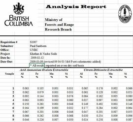
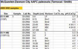
  • Kluane crust Min N (2003) S671FINL.xls [mineralizable nitrogen for biological soil crusts & upper mineral soil, 2003 samples]
  • Kluane Crust samples (2004) moisture contents.xls [moisture content of air-dry 2004 crust samples from Peninsula & Silver City sites; sampling procedures & locations in Marsh et al. (20060]
  • Kluane Soil Crusts (2004) chemical analyses.xls [consolidated file of chemical data for 2004 crust samples from Peninsula & Silver City sites]
  • Kluane 2003 soil & crust 15N data.xls [15N natural abundance, total N, organic & inorganic C for 2003 crust & upper mineral soil samples]
  • Kluane 2003 soil data.xlsx [consolidated file of chemical data for 2003 crust and mineral horizon soil samples]
  • Kluane Crust 2004 total C & N data.xls
  • Kluane AMS dates (2003-2008 charcoal samples).xls [radiocarbon dates from the University of Arizona Accelerator Mass Spectrometry Lab]
  • Kluane soil transect - texture data.xls [2009 soil particle size analysis data, with potential lithological breaks highlighted]
  • Kluane surveys 2009.xls [topographic surveys for 3 soil transects cutting across eskers along Cultus Bay Rd., SE shore of Kluane L.]
  • S1061_1069_Final_Rev1.xls [lab data report from Ministry of Forests Analytical Chemistry Laboratory for 2009 transect samples: total C, inorganic C, & total N]
  • 100812003 (annotated) -corrected.xls [2009 transect samples: particle size analysis data report from CANTEST]
  • Kluane soil transect - master data file.xls
2023.2.2.13.1 · File · 2007-2008
Part of Dr. Paul Sanborn fonds

File contains the following data sets:

  • S925finl.xls [chemical analysis data, Ministry of Forests & Range, Analytical Chemistry Laboratory for pedons Y07-06 & Y07-07; also includes data for BC07-03 & BC07-04 (Boreal Cordillera grassland soils – see associated file note)]
  • S1007finl_revised2.xls [chemical analysis data, Ministry of Forests & Range, Analytical Chemistry Laboratory for pedons Y07-06 & Y07-07: oxalate & dithionite extractions, P retention; also includes P retention data for Nazko pedons BC07-07 & BC07-09]
  • CANTEST lab report 90206003.pdf [particle size analyses for Klutan Glacier pedons Y07-06 & Y07-07; also Tuya pedons BC07-03 & BC07-04 &]
2023.7.3.26 · File · 1987
Part of Grant Hazelwood fonds

File consists of an original draft copy of the "Kokanee Glacier Park Master Plan", as well as the "Background Report for Kokanee Glacier Park Master Plan" and the "Kokanee Glacier Park Master Plan: Public Handout and Questionnaire". These items are accompanied by correspondence related to the Master Plan.

2007.1.25.8 · File · 1963-1980
Part of Aleza Lake Research Forest fonds

File contains various correspondence regarding 1964 annual cuts for sawmills in the area, memoranda consisting of various administrative issues such as the 1973 amalgamation of Purden Lake and Aleza Lake, and the sale of lumber previously infested by spruce beetles. File also contains 1972 applications to purchase Crown timber and road use, as well as 1966 logging permits.

2023.2.2.6.3 · File · 1983-2009
Part of Dr. Paul Sanborn fonds

During the 1980s, Agriculture Canada pedologists Scott Smith (retired from Summerland Research Station, formerly based in Whitehorse) and Charles Tarnocai (retired from Central Experimental Farm, Ottawa) had a large field program which addressed the trends in soil development in the central Yukon. Across this region, particularly between Whitehorse and Dawson City, the land surfaces and surficial deposits vary greatly in age due to the differing extents of glaciations over the past ~2 million years.

Tarnocai and Smith shared the unpublished data and soil samples from this work with Dr. Paul Sanborn, and this resulted in a student project published as:
Daviel, E., P. Sanborn, C. Tarnocai, and C.A.A. Smith. 2011. Clay mineralogy and chemical properties of argillic horizons in central Yukon paleosols. Canadian Journal of Soil Science 91: 83-93. https://doi.org/10.4141/cjss10067

This data set consists of transcribed data from lab data sheets, showing McQuesten-Dawson City paleosol data from the Tarnocai and Smith 1983 AAFC Yukon Paleosol Study. The data set includes chemical and particle size data for Tarnocai & Smith samples, as determined by the Ag Canada lab. Note that the “Site” column indicates the NTS topographic map sheet (e.g. 115P/13) for the sampling locations.

2023.2.2.9.4 · File · 2001
Part of Dr. Paul Sanborn fonds

File contains the following data sets:

  • Phytolith contents.xls [phytolith content in 5-20 µm silt, tallied by morphological categories; also summarized as % of total soil fine (< 2 mm) fraction]
  • M-K (2001) soil LOI data.pdf [LOI (loss-on-ignition) data for sampled soil horizons – proxy measurement for organic matter content]
2007.1.45.49 · File · 1929-1958
Part of Aleza Lake Research Forest fonds

File contains handwritten cross section book, original studies with handwritten measurement charts and black and white photos, loose pages of original correspondence, handwritten diagrams and measurement charts, loose handwritten tally sheets, black and white photographs, hand coloured plot diagrams, photocopies of aerial photographs, and original correspondence for Plot 160.

2006.18.5.18 · File · 1974
Part of Aleza Lake Research Forest Society fonds

File is a Resource Folio of maps and accompanying information created by Northwood Pulp & Timber regarding Timber Sale Harvesting Licence A01847, Willow River Block, Willow River P.S.Y.U. Includes maps that depict ungulates, waterfowl, recreation areas, special influence areas, and timber types. Most of the sheets have a duplicate, some with very slight variations. The following maps are supposed to be included in the but were missing upon arrival at the Archives: fish & topography, cutting permits & roads, and soils.

2006.18.6.05 · File · Jan. 1992
Part of Aleza Lake Research Forest Society fonds

File consists of a photograph commemorating the signing of the first Aleza Lake Research Forest Management Plan. Front row, left to right: Ken Pendergast, BC Forest Service Prince George District Manager; Harry Coates, BCFS Forest Research Technician (1957-1993); John Revel, BCFS Silviculture Forester (1960-1993). Back row, left to right: Mike [?], BCFS Prince George Silviculture Manager; Henry Benskin, BCFS Research Branch; Michael Jull, BCFS Research Silviculturist, Prince George Region; Dan Lousier, BCFS Prince George Region Research Section Head; Brian Harding, Northwood Pulp & Timber Ltd. Woodlands Manager.