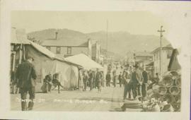
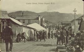
Showing 21791 results

Archival description
Centre Street Prince Rupert
2009.7.1.251 · Item · ca. 1880-1920
Part of Archdeacon W. H. Collison fonds

Photograph of residents in motion on Centre Street in Prince Rupert. Buildings are visible on either side of the street and a railway track runs down the length of the road. Annotation on recto reads: "Centre Street, Prince Rupert, BC. 1664."

Ceremonial Regalia
2009.7.1.169 · Item · [ca. 1900]
Part of Archdeacon W. H. Collison fonds

Photograph features an arranged collection of Chief’s ceremonial regalia: Chikat robe and Amalayt (headdress), two carved wooden rattles and two leggings.

Handwritten annotation in pen on recto reads: “Qush ahlied (?) or Chilcat [sic] Robe worn by Chiefs when entertaining. Also 'Ahm Ahlied'(?) or Head Ornament Indian Coronet and leggings." Verso also has additional handwritten annotations which have been crossed out.

Chalkboard Snowman
2012.13.1.86.14 · Item · [1976?]
Part of J. Kent Sedgwick fonds

Image depicts a snowman drawn on the chalkboard of what appears to be an unused school, possibly in Lamming Mills, B.C. The slide is labelled "note board school."

2009.6.1.556 · Item · [1992?]
Part of The Honourable Iona Campagnolo fonds

Unidentified women stands in centre background with arm raised, and a young girl sits on post in foreground. Photograph was taken during the chancellor's tour of Xats'ull Heritage Village, Soda Creek First Nation, Williams Lake, B.C.

Handwritten annotation on verso reads: "UNBC 1992".

2009.6.1.553 · Item · [1992?]
Part of The Honourable Iona Campagnolo fonds

Left to right: Charles Jago and unidentified woman, David Fish, Dennis Macknak, Deborah Poff, unidentified woman and child, Iona Campagnolo, Lee Morrison, Ellen Facey, two unidentified women. Teepees visible in background. Photograph was taken during the chancellor's tour of Xats'ull Heritage Village, Soda Creek First Nation, Williams Lake, B.C.

2009.6.1.554 · Item · [1992?]
Part of The Honourable Iona Campagnolo fonds

Handwritten notation affixed to verso reads: "Iona w/ Lee Morrison (late) director of First Nations Centre at that time. Soda Creek / net fishing for elders".

Photograph was taken during the chancellor's tour of Xats'ull Heritage Village, Soda Creek First Nation, Williams Lake, B.C.

2009.6.1.580 · Item · July 1996
Part of The Honourable Iona Campagnolo fonds

Left to right: Deborah Poff, Dennis Macknak, Charles Jago, an unidentified woman, Iona Campagnolo, an unidentified man, Ellen Facey, and an unidentified woman. Unknown man stands on lower deck in foreground. Mountains visible in background. Photograph taken during the Chancellor's 1996 regional tour through Atlin and Whitehorse; see also items 2009.6.1.578 - 2009.6.1.581.

Handwritten annotation on verso reads: "#3 Chancellor's Tour".

2009.6.1.581 · Item · July 1996
Part of The Honourable Iona Campagnolo fonds

Left to right: Deborah Poff, Dennis Macknak, Charles Jago, an unidentified woman, Iona Campagnolo, Ellen Facey, Nick Petraryszak, an unidentified man, and an unidentified woman. Unknown man stands on lower deck in foreground. Mountains visible in background. Photograph taken during the Chancellor's 1996 regional tour through Atlin and Whitehorse; see also items 2009.6.1.578 - 2009.6.1.580.

2009.6.1.578 · Item · [1996 or 1997]
Part of The Honourable Iona Campagnolo fonds

Photograph believed to have been taken during the Chancellor's 1996 regional tour through Atlin and Whitehorse; see also items 2009.6.1.579 - 2009.6.1.581.

Handwritten annotation on verso reads: “97, Whitehorse Tour, Page 3, Chancellor & President in Whitehorse, Chancellor’s Tour”.

2009.5.3.24 · Item · [ca. 1914]
Part of Taylor-Baxter Family Photograph Collection

Photograph depicts four men standing near fully packed horse-drawn cart in front of wood buildings, including a long building with a porch and chairs. Trees on hill visible in background. Handwritten annotation on recto of photograph: "Changing teams on the Cariboo Road".

2023.2.2.13.2.07 · Item · 8 Jul. 2007
Part of Dr. Paul Sanborn fonds

This image is part of the outbound sequence of aerial images obtained on the helicopter flight to the Klutlan Glacier study site. The sequence starts from the base camp at the White River crossing on the Alaska Highway and heads south, to a point just upvalley of the debris-covered terminus (approx. 10-15 km from Alaska border), and turning back north to the landing spot on the Generc River floodplain close to the study site (see Fig. 1 in paper).