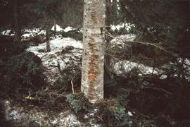
Aperçu avant impression Fermer

Affichage de 3113 résultats

Archival description
Across the bay
2009.7.1.276 · Pièce · [ca. 1880-1920]
Fait partie de Archdeacon W. H. Collison fonds

Photograph of the bay at dusk. Trees and distant machinery are silhouetted against a cloudy sky and dark waterfront. Annotation on recto reads: "Across the Bay, Prince Rupert, BC No 4466."

After the blast 24 April 1913
2009.7.1.260 · Pièce · 24 April 1913
Fait partie de Archdeacon W. H. Collison fonds

Foreground shows a rocky shore covered in debris. A small crowd is visible along the coastline, and there are foggy outlines of hills beyond the water. Annotation on recto reads: "McRae Bros After the Blast 24th Apr. 13."

Agriculture
2012.13.1.3.036 · Pièce · Nov. 1977
Fait partie de J. Kent Sedgwick fonds

Image depicts an agricultural field, most likely near Prince George, B.C.

Air Photo Markers
2012.13.1.121.01 · Pièce · 1966
Fait partie de J. Kent Sedgwick fonds

Image depicts a marker for aerial photography at an uncertain location. The slide labels it as "Elizabeth Station."

Alaska Ferry
2012.13.1.77.13 · Pièce · Aug. 1979
Fait partie de J. Kent Sedgwick fonds

Image depicts the ferry to Alaska in the port of Prince Rupert, B.C.

Alaska Highway
2012.13.1.98.59 · Pièce · 1999
Fait partie de J. Kent Sedgwick fonds

Image depicts a small section of the Alaska Highway somewhere near Whitehorse, Y.T. The slide also appears to be labelled "army washing" for unknown reasons.

2006.18.1.01 · Dossier · 1990-1996
Fait partie de Aleza Lake Research Forest Society fonds

File consists of:

  • "A Summary of Historical Orders-in-Council affecting the Aleza Lake Forest Reserve", Mike Jull, 18 Dec. 1996
  • Photocopied memorandum from F.S. McKinnon regarding "Transfer of Aleza Lake to D.F. Prince George", 9 Sept. 1963
  • Photocopied 1928 article by P.M. Barr from Forestry Chronicle 4(3) entitled "The Aleza Lake Experiment Station: Its Development and Purpose"
  • "A Brief History of the Aleza Lake Experiment Station", [Tim Decie, 1981?]
  • Contact information for living relatives of Percy Barr, as of 1990
  • Photocopy of 1930 article by Percy Barr entitled "Spruce Reproduction in British Columbia"
  • Photocopy of records from BC Archives from a visit by Harry Coates from the file GR 1348 "The Young Mens Forestry Training Program"
  • Photocopy of excerpt regarding "Amanita Lake/Diameter Limit Logging"
  • Various small-scale maps and charts regarding Aleza Lake
  • "Aleza Lake Research Forest Information Session Notes with Mike Jull, Manager of ALRF"
Aleza Lake Research Forest Plot 103
2006.18.5.45 · Pièce · Mar. 1994
Fait partie de Aleza Lake Research Forest Society fonds

Mylar map is a plot map of a research plot at the Aleza Lake Research Forest. Provides date the plot was established, the harvest history, the silviculture history, remeasurement history, and information about individual trees.

Aleza Lake Research Forest Plot 106
2006.18.5.46 · Pièce · Mar. 1994
Fait partie de Aleza Lake Research Forest Society fonds

Mylar map is a plot map of a research plot at the Aleza Lake Research Forest. Provides date the plot was established, the harvest history, the silviculture history, remeasurement history, and information about individual trees.

Aleza Lake Research Forest Plot 107
2006.18.5.47 · Pièce · Mar. 1994
Fait partie de Aleza Lake Research Forest Society fonds

Mylar map is a plot map of a research plot at the Aleza Lake Research Forest. Provides date the plot was established, the harvest history, the silviculture history, remeasurement history, and information about individual trees.

Aleza Lake Research Forest Plot 112
2006.18.5.48 · Pièce · Mar. 1994
Fait partie de Aleza Lake Research Forest Society fonds

Mylar map is a plot map of a research plot at the Aleza Lake Research Forest. Provides date the plot was established, the harvest history, the silviculture history, remeasurement history, and information about individual trees.

Aleza Lake Research Forest Plot 115
2006.18.5.49 · Pièce · Mar. 1994
Fait partie de Aleza Lake Research Forest Society fonds

Mylar map is a plot map of a research plot at the Aleza Lake Research Forest. Provides date the plot was established, the harvest history, the silviculture history, remeasurement history, and information about individual trees.

Aleza Lake Research Forest Plot 117
2006.18.5.50 · Pièce · Mar. 1994
Fait partie de Aleza Lake Research Forest Society fonds

Mylar map is a plot map of a research plot at the Aleza Lake Research Forest. Provides date the plot was established, the harvest history, the silviculture history, remeasurement history, and information about individual trees.

Aleza Lake Research Forest Plot 118
2006.18.5.51 · Pièce · Mar. 1994
Fait partie de Aleza Lake Research Forest Society fonds

Mylar map is a plot map of a research plot at the Aleza Lake Research Forest. Provides date the plot was established, the harvest history, the silviculture history, remeasurement history, and information about individual trees.

Aleza Lake Research Forest Plot 119
2006.18.5.52 · Pièce · Mar. 1994
Fait partie de Aleza Lake Research Forest Society fonds

Mylar map is a plot map of a research plot at the Aleza Lake Research Forest. Provides date the plot was established, the harvest history, the silviculture history, remeasurement history, and information about individual trees.

Aleza Lake Research Forest Plot 148
2006.18.5.53 · Pièce · Mar. 1994
Fait partie de Aleza Lake Research Forest Society fonds

Mylar map is a plot map of a research plot at the Aleza Lake Research Forest. Provides date the plot was established, the harvest history, the silviculture history, remeasurement history, and information about individual trees.