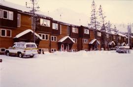
Aperçu avant impression Fermer

Affichage de 1971 résultats

Archival description
1322 résultats avec objets numériques Afficher les résultats avec des objets numériques
2000.1.1.3.19.138 · Pièce · [ca. 1980]
Fait partie de Cassiar Asbestos Corporation Ltd. fonds

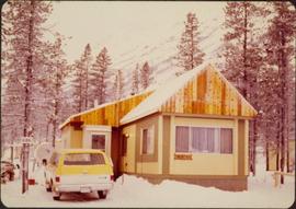
Photograph depicts mobile home modified for Cassiar winters (steeply sloped roof added). Yellow suburban parked in driveway in left foreground. Forest trees and mountainside visible in background. Sign reading "686" posted on tree in left foreground. Believed to be the home of Gerry Cooper.

Community Album - Church Interior
2000.1.1.3.19.175 · Pièce · [ca. 1980]
Fait partie de Cassiar Asbestos Corporation Ltd. fonds

Photograph depicts interior of church believed to be the All Saints Anglican Community Church at Cassiar, B.C. Table and pulpit in foreground, pews and door in background. Stained glass windows line both sides of the building.

Cominco Ltd. In Kimberley, B.C.
2013.6.36.1.010.50 · Pièce · Oct. 1965
Fait partie de David Davies Railway Collection

Photograph depicts the Cominco Ltd. In Kimberley, near Cranbrook. There is a 3' gauge overhead electric railway serving the underground workings of Sullivan mine. The view shows the C.P.R. access in the valley and the old mine portal, still used for in-going materials and supplies, at the right center of the photo.

Coking ovens at Union Bay
2013.6.36.1.005.08 · Pièce · Aug. 1964
Fait partie de David Davies Railway Collection

Photograph depicts the coking ovens at Union Bay on Vancouver Island. They belong to the Canadian Collieries Ltd. and the date last used is unknown.

Coaling wharf at Union Bay
2013.6.36.1.005.09 · Pièce · Aug. 1964
Fait partie de David Davies Railway Collection

Photograph depicts the coaling wharf at Union Bay on Vancouver Island. It is the property of the Canadian Colliery Resources Ltd. It was last used on August 15, 1960. Thereafter, all equipment and railways were dismantled but the water tank is still standing.

Coal miners near Buckley Bay
2013.6.36.1.003.047 · Pièce · Aug. 1964
Fait partie de David Davies Railway Collection

Photograph depicts coal miners near Buckley Bay. The afternoon shift (3 p.m.) is going down the Tsable drift mine, which is the only working coal pit on Vancouver Island in 1964 and has a total of 70 employees. It is run by the Comox Colliery Co. and has a daily production of 200-300 tons.

2000.1.1.3.04 · Dossier · [ca. 1978]
Fait partie de Cassiar Asbestos Corporation Ltd. fonds

File contains 6 slide presentations depicting training material for the operation of a P&H excavator published by the Harnischfeger Institute. The presentations depict an introduction to excavator controls and techniques for proper hoist motion, proper swing motion, concerning haulage units, proper propel motion, and proper crowd motion.

Clinton Creek Operations
2000.1.1.3.20 · Dossier · 1961 - [ca.1975]
Fait partie de Cassiar Asbestos Corporation Ltd. fonds

Cassiar Asbestos Corporation Ltd opened a second mine in 1967 at what became the one-industry town of Clinton Creek, Y.T. File contains photographs depicting different areas of operations at Clinton Creek. Locations include the mine, plant, town, tailings pile, main office, the 40 Mile River, and surrounding area. Town photos depict the grocery store, cafeteria, medical clinic, school, auditorium residential area, Connell Street and power house. File also includes aerial photographs and images depicting forest fighting, photographers capturing the tailings pile, asbestos samples, mining machinery, staff offices, and operations in the mill, lab, and garage.

Additional photographs integrated into file depict Clinton Creek's surrounding area, and three slides of a tailing pile explosion believed to be Clinton Creek.

Clinton Creek Construction
2000.1.1.2.08 · Dossier · 1966 - 1967
Fait partie de Cassiar Asbestos Corporation Ltd. fonds

Cassiar Asbestos Corporation Ltd opened a second mine in 1967 at what became the one-industry town of Clinton Creek, Y.T. File contains photographs depicting progressive construction of buildings at the Clinton Creek mine, plant, townsite and powerhouse. Mine photos depict the crusher site and tramline station. Plant photos depict the dryer, fibre storage, mill, service, vault, and office buildings, as well as the dry rock storage tunnel, reclaim tunnel, and loading dock. Construction living quarters are depicted as well as the construction of residences at the townsite. The power house was built south of the town and plant, on the shore of the 40 Mile River. Some annotations describe the type of material being used for construction.

Clear Cut Logging
2012.13.1.122.03 · Pièce · Oct. 1975
Fait partie de J. Kent Sedgwick fonds

Image depicts a highway, and a section of mountain in the background which is bare due to clear-cut logging. It is possibly somewhere near Prince George, B.C.

Clear Cut Logging
2012.13.1.122.04 · Pièce · Oct. 1975
Fait partie de J. Kent Sedgwick fonds

Image depicts a logging area, and a section of mountain in the background which is bare due to clear-cut logging. The slide is also labelled "logging show." It is possibly somewhere near Prince George, B.C.

2000.1.1.4.3.01 · Pièce · [ca. 1951]
Fait partie de Cassiar Asbestos Corporation Ltd. fonds

Photograph depicts close view of four men in formal attire holding beverages while having a discussion. Left to right: Jack Christian (President Cassiar), Fred Martin Connell (Chairman and Chairman of Conwest Exploration Company Limited), W. Harold Connell (older brother of FM and Director of Conwest), and Charles Rainforth Elliot (Director and President of Conwest Exploration). Framed painting visible on wall in background.

2000.1.1.4.3.02 · Pièce · [ca. 1951]
Fait partie de Cassiar Asbestos Corporation Ltd. fonds

Photograph depicts close view of four men in formal attire holding beverages while having a discussion. Left to right: Jack Christian (President Cassiar), Fred Martin Connell (Chairman and Chairman of Conwest Exploration Company Limited), W. Harold Connell (older brother of FM and Director of Conwest), and Charles Rainforth Elliot (Director and President of Conwest Exploration). Framed painting visible on wall in background.

Chip car at Prince George Pulp & Paper
2000.13.1.38 · Pièce · [196-].
Fait partie de Ray Williston fonds

Item is a photograph of a CP Rail chip car being dumped. The development of the interior chip pulp industry necessitated new designs for chip rail cars and their dumping facilities.

Charles Melville Hays
2000.23.1.057 · Dossier · 1980
Fait partie de Audrey Smedley L'Heureux fonds

File consists of material relating to Charles Melville Hays (May 16, 1856 - April 15, 1912) who was the president of the Grand Trunk Railway. He began working in the railroad business as a clerk at the age of 17 and quickly rose through the ranks of management to become the General Manager of the Wabash, St. Louis and Pacific Railway. He became Vice-President of that company in 1889 and remained as such until 1896 when he became General Manager of the Grand Trunk Railway (GTR) of Canada. He died in the sinking of the RMS Titanic before his plan was complete. File consists of newspaper clippings, correspondence, and reproductions of articles.

Certain Teed
2000.1.1.1.31 · Pièce · 1970
Fait partie de Cassiar Asbestos Corporation Ltd. fonds

This photograph is an aerial depiction of what is believed to be a Certain Teed factory in the United States. Certain Creed is a manufacturing company that supplies building materials. They have been in operation since 1904 to present. This photograph was found along with invoices, shipping orders and correspondence between Certain Teed and Cassiar.

Cassiar Valley, Tree Silhouette
2000.1.1.3.13.04 · Pièce · [before 1970]
Fait partie de Cassiar Asbestos Corporation Ltd. fonds

Photograph depicts the Cassiar townsite behind shadow in foreground. Plantsite can be seen including the mill, dry rock storage building, tailings pile, and many other buildings. Mountains in background. Handwritten annotation on recto: "<- 13 1/2" ->". (This photograph was made into a promotional poster.)

Cassiar Staff
2000.1.1.3.28 · Dossier · 1990
Fait partie de Cassiar Asbestos Corporation Ltd. fonds

Photographs of various Cassiar Staff at work. There is extensive annotations on the back of each photo explaining who is depicted and where they are working.

Cassiar Land
2000.1.1.3.25 · Dossier · 1979 - 1983
Fait partie de Cassiar Asbestos Corporation Ltd. fonds

This file contains images of a land dispute around Cassiar. The photographs depict a cabin on a lot, a destroyed cabin, and outhouses. The accompanied documents in the original file refer to the subjects of "Claims, Leases, and Land lots," and it is implied that there were issues of squatters, illegal occupation, and mineral claims.

Cassiar Asbestos Corporation Ltd. fonds
2000.1 · Fonds · 3 April 1952 - 15 March 1993

Fonds consists of textual, photographic, cartographic, electronic and promotional films/video recordings related to the mining operations of Cassiar Asbestos Mining Corporation (CAMC) and creation of Cassiar townsite. CAMC records primarily consist of records related to mining operations including construction, engineering, daily mining operations, administration of CAMC, tallies of extractions, labour and union activities, corporate events and visits by dignitaries. Townsite records are primarily visual representations of townsite construction, including the creation of health, education and community services including Cassiar's private hospital, school, library, as well as townsite images. Photographs include documentation of natural and man-made landscapes within the Cassiar region of Northern BC. Other holdings include a near complete run of Cassiar's community newspaper.

Sans titre
Cassiar Aerial Photographs
2000.1.1.3.13 · Dossier · 1950 - 1992
Fait partie de Cassiar Asbestos Corporation Ltd. fonds

Photographs depict aerial views of the Cassiar townsite, plantsite, tailings pile, mine road, bench and pit mine, mine buildings (tramline loading station, crusher, shop, and garage), and surrounding mountain range. Here "aerial" refers to photos depicting a large area and taken from the air or from a high point of elevation.

Cartographic Materials Series
2009.7.3 · Série organique · 1878-1929
Fait partie de Archdeacon W. H. Collison fonds

Maps within this series document the placer streams, islands and harbours of the Queen Charlotte Islands; as well as the mining properties located within the vicinity of Stewart, BC.