Showing 20447 results

Archival description
20447 results with digital objects Show results with digital objects
2009.7.1.219 · Item · [ca. 1939]
Part of Archdeacon W. H. Collison fonds

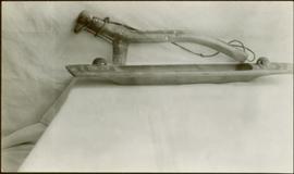
An unidentified carved wooden tool or utensil with twine attached, leans against a sheet covered wall behind a carved wooden platter. Stamped annotation on verso reads: “Department of Mines and Resources, Photographic Section. Oct. 6, 1939”. Numeric annotation on verso: “50-3”

Carving a Totem Pole
2012.13.1.84.24 · Item · 1994
Part of J. Kent Sedgwick fonds

Image depicts several unidentified individuals inside a building, one of which is carving a totem pole. The location is uncertain.

Carving a Totem Pole
2012.13.1.84.25 · Item · 1994
Part of J. Kent Sedgwick fonds

Image depicts several unidentified individuals inside a building, one of which is carving a totem pole. The location is uncertain.

Cascade River in Cassiar
2004.1.2.4.105 · Item · ca. 1939 (?)
Part of Phipps-Mackenzie Collection

Photograph depicts a section of white water along the Cascade River. Annotation on versio: "August (?), Cassiar, Cascade River, A.H. Phipps".

Cassiar - Stewart Highway
2006.20.9.25 · Item · [ca. 1897 - 1960]
Part of Northern BC Archives Historical Photograph Collection

View of snow capped mountains in the distance, vast rolling treed hills in mid ground and a gravel road in the foreground. Road sign indicating severe curve in road situated at the right of the gravel road. Handwritten annotation on verso in pen reads: “Cassiar – Stewart highway”

Cassiar Aerial
2000.1.1.1.07.09 · Item · [ca. 1965]
Part of Cassiar Asbestos Corporation Ltd. fonds

Photograph depicts the Cassiar town in foreground, mine valley and north mountain range in background. Photograph speculated to have been taken during the plane ride of an outside exploration trip.

Cassiar Aerial - Mine Valley
2000.1.1.1.07.08 · Item · [ca. 1965]
Part of Cassiar Asbestos Corporation Ltd. fonds

Photograph depicts the Cassiar mine valley in north mountain range. Plant and tailings pile can be seen in right foreground, and the east end of the town is visible in left foreground. Photograph speculated to have been taken during the plane ride of an outside exploration trip.

Cassiar Aerial, East View
2000.1.1.1.07.10 · Item · [ca. 1965]
Part of Cassiar Asbestos Corporation Ltd. fonds

Photograph depicts the Cassiar valley, showing the east end of town in foreground. Plant and tailings pile can be seen in right midground. Photograph speculated to have been taken during the plane ride of an outside exploration trip.

2000.1.1.3.13.04 · Item · [before 1970]
Part of Cassiar Asbestos Corporation Ltd. fonds

Photograph depicts the Cassiar townsite behind shadow in foreground. Plantsite can be seen including the mill, dry rock storage building, tailings pile, and many other buildings. Mountains in background. Handwritten annotation on recto: "<- 13 1/2" ->". (This photograph was made into a promotional poster.)

2009.5.2.58 · Item · [ca. 1913]
Part of Taylor-Baxter Family Photograph Collection

Photograph depicts Catholic church, with rectory on its left, and First United Church behind. A wood boardwalk crosses midground, and a man can be seen riding a bicycle near church. Power lines and rough cleared land in foreground, hills and mountains in background. Handwritten annotation on recto of photograph: "Church in Rupert."

2013.6.36.1.016.26 · Item · 14 Oct. 1974
Part of David Davies Railway Collection

Photograph depicts a cattle dock about 1/4 mile west of the former site of the Haney CPR depot. To the left and west of the dock is a meat processing plant which used to use the dock but does not anymore. The view is looking northeast.