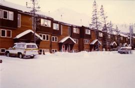
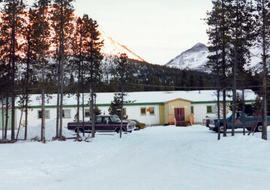
Print preview Close

Showing 1028 results

Archival description
1028 results with digital objects Show results with digital objects
Community Album - Bunkhouse
2000.1.1.3.19.112 · Item · [ca. 1980]
Part of Cassiar Asbestos Corporation Ltd. fonds

Photograph depicts an unidentified man walking in front of orange and brown two-story building speculated to be bunkhouse residences. Second unknown individual can be seen unloading car in left foreground. Trees and mountains visible in background.

2000.1.1.3.13.04 · Item · [before 1970]
Part of Cassiar Asbestos Corporation Ltd. fonds

Photograph depicts the Cassiar townsite behind shadow in foreground. Plantsite can be seen including the mill, dry rock storage building, tailings pile, and many other buildings. Mountains in background. Handwritten annotation on recto: "<- 13 1/2" ->". (This photograph was made into a promotional poster.)

Cassiar Land
2000.1.1.3.25 · File · 1979 - 1983
Part of Cassiar Asbestos Corporation Ltd. fonds

This file contains images of a land dispute around Cassiar. The photographs depict a cabin on a lot, a destroyed cabin, and outhouses. The accompanied documents in the original file refer to the subjects of "Claims, Leases, and Land lots," and it is implied that there were issues of squatters, illegal occupation, and mineral claims.

Cassiar Aerial, East View
2000.1.1.1.07.10 · Item · [ca. 1965]
Part of Cassiar Asbestos Corporation Ltd. fonds

Photograph depicts the Cassiar valley, showing the east end of town in foreground. Plant and tailings pile can be seen in right midground. Photograph speculated to have been taken during the plane ride of an outside exploration trip.

Cassiar Aerial - Mine Valley
2000.1.1.1.07.08 · Item · [ca. 1965]
Part of Cassiar Asbestos Corporation Ltd. fonds

Photograph depicts the Cassiar mine valley in north mountain range. Plant and tailings pile can be seen in right foreground, and the east end of the town is visible in left foreground. Photograph speculated to have been taken during the plane ride of an outside exploration trip.

Cassiar Aerial
2000.1.1.1.07.09 · Item · [ca. 1965]
Part of Cassiar Asbestos Corporation Ltd. fonds

Photograph depicts the Cassiar town in foreground, mine valley and north mountain range in background. Photograph speculated to have been taken during the plane ride of an outside exploration trip.

Camp at Quartz Creek
2000.1.1.1.02.07 · Item · [June 1951?]
Part of Cassiar Asbestos Corporation Ltd. fonds

Photograph depicts three small camp structures in dirt landscape: one trailer, one wooden building and one tent building. Logs and wood pile in foreground, forest and snow-capped mountain in background.

Bulldozer on Talus Slope
2000.1.1.1.06.04 · Item · [1966?]
Part of Cassiar Asbestos Corporation Ltd. fonds

Photograph believed to have been taken near Kutcho Creek, BC during an outside exploration trip led by Cassiar's Chief Geologist Bill Plumb. Bill stands to left of man believed to be Matt Bell in right foreground. Bulldozer works along talus slope in left foreground.

Bulldozer on Talus Slope
2000.1.1.1.06.05 · Item · [1966?]
Part of Cassiar Asbestos Corporation Ltd. fonds

Bulldozer works along talus slope in centre of image. Photograph believed to have been taken near Kutcho Creek, BC during an outside exploration trip led by Cassiar's Chief Geologist Bill Plumb.