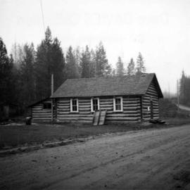
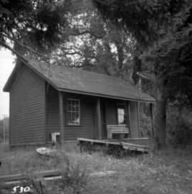
Showing 3218 results

Archival description
Upper Fraser General Store
2012.13.1.87.043 · Item · [between 1975 and 1995]
Part of J. Kent Sedgwick fonds

Image depicts the Upper Fraser General Store in Upper Fraser, B.C. Two other signs indicate that it is also a post office and a place that offers propane refills. Map coordinates 54°07'10.8"N 121°56'51.7"W

Upper Fraser Mill
2012.13.1.87.044 · Item · [between 1975 and 1995]
Part of J. Kent Sedgwick fonds

Image depicts entrance to mill yard for Upper Fraser mill in Upper Fraser, B.C. Map coordinates 54°07'10.8"N 121°56'51.7"W

Upper Fraser Mill
2012.13.1.87.046 · Item · [between 1975 and 1995]
Part of J. Kent Sedgwick fonds

Image depicts Upper Fraser mill yard with log deck and beehive burner in silhouette across railroad tracks. Located in Upper Fraser, B.C. Map coordinates 54°07'01.5"N 121°56'29.6"W

Upper Fraser Mill
2012.13.1.87.064 · Item · [between 1975 and 1995]
Part of J. Kent Sedgwick fonds

Image depicts numerous log decks at the Upper Fraser sawmill. Map coordinates 54°07'10.8"N 121°56'51.7"W

Upper Fraser Mill
2012.13.1.87.062 · Item · [between 1975 and 1995]
Part of J. Kent Sedgwick fonds

Image depicts the entrance to the Upper Fraser mill yard in Upper Fraser, B.C. Map coordinates 54°07'10.8"N 121°56'51.7"W

Upper Fraser Mill
2012.13.1.87.063 · Item · [between 1975 and 1995]
Part of J. Kent Sedgwick fonds

Image depicts the Upper Fraser mill yard with a CN train in Upper Fraser, B.C. Map coordinates 54°07'10.8"N 121°56'51.7"W

Upper Fraser Mill
2012.13.1.87.061 · Item · [between 1975 and 1995]
Part of J. Kent Sedgwick fonds

Image depicts the entrance to the Upper Fraser mill yard in Upper Fraser, B.C. Map coordinates 54°07'10.8"N 121°56'51.7"W

Upper Fraser Mill
2012.13.1.87.066 · Item · [between 1975 and 1995]
Part of J. Kent Sedgwick fonds

Image depicts the Upper Fraser Road running through Upper Fraser, B.C. A newer style round burner is seen in the background. Map coordinates 54°07'05.7"N 121°56'38.9"W

Upper Fraser Residences
2012.13.1.87.047 · Item · [between 1975 and 1995]
Part of J. Kent Sedgwick fonds

Image depicts an older building with numerous vehicles parked out front in Upper Fraser, B.C. Map coordinates 54°07'03.5"N 121°56'34.4"W

2012.13.1.87.041 · Item · [between 1975 and 1995]
Part of J. Kent Sedgwick fonds

Image depicts the Upper Fraser Road running through Upper Fraser, B.C. A beehive burner is seen in the background on the left and the mill office is seen on the right. Map coordinates 54°07'05.7"N 121°56'38.9"W

Upper Fraser Road in Winter
2012.13.1.89.016 · Item · Feb. 1973
Part of J. Kent Sedgwick fonds

Image depicts several unidentified individuals walking along the snow-covered Upper Fraser Road with numerous buildings on either side. Map coordinates 54°07'05.7"N 121°56'38.9"W

Valemount
2012.13.1.85.25 · Item · [1976?]
Part of J. Kent Sedgwick fonds

Image depicts a view of Valemount, with numerous mountains in the background.

Vanderhoof
2012.13.1.51.017 · Item · May 1972
Part of J. Kent Sedgwick fonds

Image depicts a barn with large, Harvestore Systems. It is possibly located on one of the many farms near Vanderhoof, B.C.

Veteran House
2012.13.1.24.36 · Item · 2000
Part of J. Kent Sedgwick fonds

Image depicts a property given to the Veterans of the Second World War, located on the corner of 15th Avenue and Elm Street in Prince George, B.C.

View from City Hall
2012.13.1.3.045 · Item · Jan. 1978
Part of J. Kent Sedgwick fonds

Image depicts a view of Prince George from City Hall looking northeast with the pulp mills in the background. Map coordinates 53°54'46.3"N 122°44'41.9"W

2006.20.12.45 · Item · [ca. 1940]
Part of Northern BC Archives Historical Photograph Collection

Handwritten photo album caption below this photo reads: "Another view from Tower at Whitehorse." Photograph depicts various unidentified buildings, vehicles, and machinery behind dirt road in mid ground. Power poles in foreground; trees, river, and mountains in background.

Royal Canadian Air Force
2012.13.1.3.166 · Item · May 2001
Part of J. Kent Sedgwick fonds

Image depicts a view of Prince George from City Hall looking northeast along George Street. Includes a back view of the Prince George cenotaph. Map coordinates 53°54'46.3"N 122°44'41.9"W

2011.3.2.05 · Item · 1913
Part of North Coast & Central BC Postcard Collection

Lofty view of South Fort George, river and treed hills in the background. Printed annotation on verso reads: “South Fort George - 1913.” Handwritten message on recto is addressed to “Ethel M. Heurris Norton Maps Bristol County" reads: "11-1-13 an excellent view of south Fort George taken recently. Power Station at cross near water. This does not give all the south residence view. Population approx 1500”.

2006.45.17 · Item · [ca. 1897]
Part of Historical North Coast Photograph Album

View of town on shore, from above. Boats docked along piers and buildings. Hills visible on either side of water in background.

Handwritten photo captions with arrows pointing to sections of image read: "General Merchandise", "Fort Wrangell Hotel".

2008.3.3.3.1 · Item · 26 May 1995
Part of Bridget Moran fonds

Photograph depicts road at University of Northern British Columbia. Library building stands in center background. Administration and cafeteria buildings can be seen in left background. Accompanying note from Maureen Faulkner: "Walking up to Canada's newest 'U' - ". Photo believed to have been taken on the day Bridget Moran received an Honourary Law Degree.