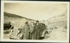
Previsualizar a impressão Fechar

Mostrar 3093 resultados

Archival description
3093 resultados com objetos digitais Mostrar resultados com objetos digitais
Unknown Men in Mining Area
2009.5.2.38 · Item · [ca 1939]
Parte de Taylor-Baxter Family Photograph Collection

Photograph depicts three men wearing suits and ties, posed in front of car in gravel area believed to be at a mining location. Hauling truck crosses road in midground, cliffs and hills in background.

Unknown River
2009.5.2.95 · Item · [ca. 1930?]
Parte de Taylor-Baxter Family Photograph Collection

Photograph depicts river in foreground, trees on opposite shore in background. Photo also appears to depict two unidentified individuals on small boat or canoe.

Unknown Woman & Men at Mine
2000.1.1.3.15.02 · Item · 1954
Parte de Cassiar Asbestos Corporation Ltd. fonds

Photograph depicts a man and woman standing on what is believed to be an early mining bench. Two men with air track drill can be seen in background, one man father down on left, mountain range in background. Image slightly distorted due to poor quality of negative.

Upper Fraser Canyon
2012.13.1.52.30 · Item · 1980
Parte de J. Kent Sedgwick fonds

Image depicts a view of the upper Fraser Canyon. The Fraser River is visible on the left side of the image.

Upper Fraser Canyon
2012.13.1.52.31 · Item · 1980
Parte de J. Kent Sedgwick fonds

Image depicts a view of the upper Fraser Canyon. The Fraser River is visible on the left side of the image.

Upper Fraser General Store
2012.13.1.87.043 · Item · [between 1975 and 1995]
Parte de J. Kent Sedgwick fonds

Image depicts the Upper Fraser General Store in Upper Fraser, B.C. Two other signs indicate that it is also a post office and a place that offers propane refills. Map coordinates 54°07'10.8"N 121°56'51.7"W

Upper Fraser Mill
2012.13.1.87.044 · Item · [between 1975 and 1995]
Parte de J. Kent Sedgwick fonds

Image depicts entrance to mill yard for Upper Fraser mill in Upper Fraser, B.C. Map coordinates 54°07'10.8"N 121°56'51.7"W

Upper Fraser Mill
2012.13.1.87.046 · Item · [between 1975 and 1995]
Parte de J. Kent Sedgwick fonds

Image depicts Upper Fraser mill yard with log deck and beehive burner in silhouette across railroad tracks. Located in Upper Fraser, B.C. Map coordinates 54°07'01.5"N 121°56'29.6"W

Upper Fraser Mill
2012.13.1.87.064 · Item · [between 1975 and 1995]
Parte de J. Kent Sedgwick fonds

Image depicts numerous log decks at the Upper Fraser sawmill. Map coordinates 54°07'10.8"N 121°56'51.7"W

Upper Fraser Mill
2012.13.1.87.062 · Item · [between 1975 and 1995]
Parte de J. Kent Sedgwick fonds

Image depicts the entrance to the Upper Fraser mill yard in Upper Fraser, B.C. Map coordinates 54°07'10.8"N 121°56'51.7"W

Upper Fraser Road in Upper Fraser, BC
2012.13.1.87.041 · Item · [between 1975 and 1995]
Parte de J. Kent Sedgwick fonds

Image depicts the Upper Fraser Road running through Upper Fraser, B.C. A beehive burner is seen in the background on the left and the mill office is seen on the right. Map coordinates 54°07'05.7"N 121°56'38.9"W

Upper Fraser Road in Winter
2012.13.1.89.016 · Item · Feb. 1973
Parte de J. Kent Sedgwick fonds

Image depicts several unidentified individuals walking along the snow-covered Upper Fraser Road with numerous buildings on either side. Map coordinates 54°07'05.7"N 121°56'38.9"W

Uprooted Tree?
2012.13.1.78.19 · Item · 1982
Parte de J. Kent Sedgwick fonds

Image depicts an individual standing next to what appears to be the base of a very large, uprooted tree, located somewhere in the coastal forest of Haida Gwaii, B.C.

Valemount
2012.13.1.85.25 · Item · [1976?]
Parte de J. Kent Sedgwick fonds

Image depicts a view of Valemount, with numerous mountains in the background.

Valemount - Mountains
2012.13.1.85.21 · Item · 1976
Parte de J. Kent Sedgwick fonds

Image depicts a view of a mountain range near Valemount, B.C. Valemount is barely visible among the trees on the right side of the image.

Valemount - Reservoir
2012.13.1.85.24 · Item · [1976?]
Parte de J. Kent Sedgwick fonds

Image depicts a distant view of what appears to be a body of water, with numerous mountains in the background. The slide is labelled "Valemount reservoir."

Valley
2012.13.1.56.57 · Item · 1973
Parte de J. Kent Sedgwick fonds

Image depicts a view of a small valley in Mt. Robson Provincial Park.

Valley?
2012.13.1.59.13 · Item · July 1980
Parte de J. Kent Sedgwick fonds

Image depicts a river running through a valley-like area somewhere near Bralorne, B.C.

Varves
2012.13.1.124.16 · Item · Oct. 1975
Parte de J. Kent Sedgwick fonds

Image depicts an example of varves, an annual layer of sediment or rock, with a pipe used for reference size. It is possibly located at the airport in Prince George, B.C.

Varves
2012.13.1.124.15 · Item · Oct. 1975
Parte de J. Kent Sedgwick fonds

Image depicts an example of varves, an annual layer of sediment or rock, possibly located at the airport in Prince George, B.C.

View Back to Skagway
2012.13.1.100.05 · Item · 1999
Parte de J. Kent Sedgwick fonds

Image depicts a view over a forested, mountainous area and a river somewhere in the area of Skagway, Alaska.

View Down to Skagway
2012.13.1.100.23 · Item · 1999
Parte de J. Kent Sedgwick fonds

Image depicts a view over a forested, mountainous area and a river towards the vicinity of Skagway, Alaska.