2023.2.2.3.3
·
File
·
July 2004
Part of Dr. Paul Sanborn fonds
762 results with digital objects
Show results with digital objects
2023.2.2.5.8
·
File
·
2004
Part of Dr. Paul Sanborn fonds
2023.2.2.4.4
·
File
·
2004
Part of Dr. Paul Sanborn fonds
2023.2.2.5.2
·
Item
·
[ca. 1993]
Part of Dr. Paul Sanborn fonds
Carter, L. David, Thomas D. Fouch, and Michael J. Kunk. (n.d.) Physical stratigraphy and regional setting of the Lost Chicken placer mine, Alaska. [unpublished draft manuscript]
2023.2.2.5.3
·
Item
·
1993
Part of Dr. Paul Sanborn fonds
Carter, L. David, Thomas D. Fouch, C.A.Scott Smith and Michael J. Kunk. (n.d.) Physical stratigraphy, sedimentology, and regional setting of Pliocene deposits at the Lost Chicken placer mine, east-central Alaska. [unpublished draft manuscript, with cover memo from D. Carter dated Oct 15, 1993]
2023.2.2.5.1
·
Item
·
1992
Part of Dr. Paul Sanborn fonds
Adam, David P. 1992. Pliocene and Quaternary pollen from the Lost Chicken Mine, Alaska. Preliminary draft prepared for the USGS/GSC Whitehorse Workshop, April 26-28, 1992.
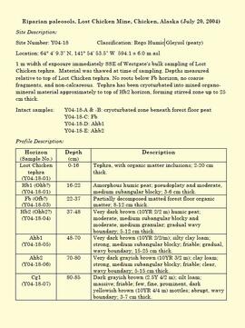
2023.2.1.04
·
File
·
1994-2005
Part of Dr. Paul Sanborn fonds
File consists of proceedings and abstracts for conferences and workshops attended by Paul Sanborn.
Includes the following items:
Alloway, B.V., D.G. Froese, and J.A. Westgate (eds.) 2005. Proceedings of the International Field Conference and Workshop on Tephrochronology & Volcanism: Dawson City, Yukon Territory, Canada, July 31st – August 8th, 2005.
BC Forestry Continuing Studies Network. 1994. Workshop proceedings: Grasses and legumes in forestry - A forum for discussing the economic and ecological costs and benefits of using grass and legume species in all phases of northern forest management. Prince George, BC: April 6-7, 1994.
Canadian Quaternary Association. 2001. Canadian Quaternary Association Meetings, 2001: Program and Abstracts. Occasional Paper in Earth Sciences No. 1. Heritage Branch, Government of the Yukon. http://emrlibrary.gov.yk.ca/Tourism/canadian-quaternary-association-meetings-program-and-abstracts-2001.pdf
Enhanced Forest Management Pilot Project. 2000. Proceedings of the March 30-31 Information Session. Robson Valley Forest District. [9 extended abstracts & full articles]
Society for Ecological Restoration. 1995. Taking a broader view: 1995 international conference. September 14-16, 1995. University of Washington, Seattle WA, USA. [program & abstracts]
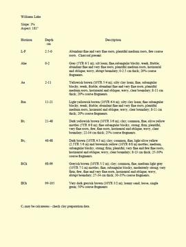
2023.2.2.2.5
·
Item
·
1996
Part of Dr. Paul Sanborn fonds
This born-digital "Profile Descriptions" document provides descriptions of Williams Lake (Skulow Lake), Aleza 1 & 2, Log Lake, and Lucille Mountain pedons.
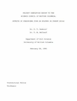
2023.2.2.1.1.1
·
Item
·
28 Feb. 1990
Part of Dr. Paul Sanborn fonds
During a year away from studies in 1987-88, Dr. Paul Sanborn developed a successful grant proposal to the Science Council of BC (SCBC) to pursue a postdoctoral project with Dr. Tim Ballard in relation to sulphur-deficient soils in BC and prescribed fire. This project built on an existing broadcast burning study conducted by Macmillan Bloedel Ltd. near Port Alberni on Vancouver Island, led by Bill Beese (later at Vancouver Island University). Dr. Sanborn's work addressed sulphur forms and amounts in the soils at these sites, and the chemical processes influencing sulphur availability in relation to prescribed fire.
Only one part of this work was eventually published:
Sanborn, P.T. and T.M. Ballard. 1991. Combustion losses of sulphur from conifer foliage: Implications of chemical form and soil nitrogen status. Biogeochemistry 12: 129–134.
https://doi.org/10.1007/BF00001810
The remainder of the work was documented in this Project Completion Report to SCBC, dated February 28, 1990, and entitled "Effects of Prescribed Fire on Sulphur in Forest Soils".
2023.2.2.9.1
·
Item
·
22 June 2000
Part of Dr. Paul Sanborn fonds
Map depicts range reference area exclosure locations for livestock and wildlife in the Fort St. John Forest District.
2023.2.2.8.07.16
·
Item
·
2003
Part of Dr. Paul Sanborn fonds
2023.2.2.4.4.084
·
Item
·
2004
Part of Dr. Paul Sanborn fonds
2023.2.2.4.4.085
·
Item
·
2004
Part of Dr. Paul Sanborn fonds
2023.2.2.4.4.086
·
Item
·
2004
Part of Dr. Paul Sanborn fonds
2023.2.2.4.4.087
·
Item
·
2004
Part of Dr. Paul Sanborn fonds
2023.2.2.4.4.088
·
Item
·
2004
Part of Dr. Paul Sanborn fonds
2023.2.2.4.4.089
·
Item
·
2004
Part of Dr. Paul Sanborn fonds
2023.2.2.4.4.090
·
Item
·
2004
Part of Dr. Paul Sanborn fonds
2023.2.2.4.4.091
·
Item
·
2004
Part of Dr. Paul Sanborn fonds
2023.2.2.2
·
Subseries
·
1995-2005
Part of Dr. Paul Sanborn fonds
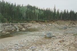
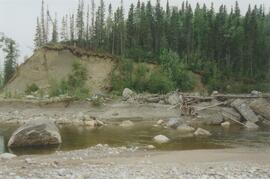
In the mid-1990s, Dr. Paul Sanborn worked with Dr. Lito Arocena of UNBC to assemble and interpret basic physical, chemical, and mineralogical data for typical soils at important long-term forestry research sites in central and northeastern BC. The key results were published as:
J.M. Arocena and P. Sanborn. 1999. Mineralogy and genesis of selected soils and their implications for forest management in central and northeastern British Columbia. Canadian Journal of Soil Science 79: 571-592. https://doi.org/10.4141/S98-07
Nine pedons were involved, with 7 located at the sites of 4 Ministry of Forests Experimental Projects (E.P.), and 2 at the Aleza Lake Research Forest.
2023.2.2
·
Series
·
1960-2024
Part of Dr. Paul Sanborn fonds
Series consists of records created and collected in relation to research projects Dr. Paul Sanborn was engaged in, often with other colleagues, during his employment with the BC Ministry of Forests and/or the University of Northern British Columbia. These archival research records are predominantly unpublished documents, reports, data, and photographs. Some of Sanborn's research projects did not result in a formal scientific publication. In other instances, some of Sanborn's research projects resulted in only a portion of the collected data utilized for a formal publication.
Sanborn compiled details about each research project and its associated records in a summary note. Each of these notes is provided in PDF format along with its research project series. These notes serve as an essential guide for researchers who wish to interpret, utilize, and repurpose Sanborn's data for other future research projects.
2023.2.1
·
Series
·
1976-2016
Part of Dr. Paul Sanborn fonds
Series consists of reference material collected by Dr. Paul Sanborn, including field trip guidebooks, resource inventory documents, collected sources for various areas of research, and proceedings and abstracts for conferences and workshops.
2023.2.1.05
·
File
·
1976-2000
Part of Dr. Paul Sanborn fonds
File consists of reports and documents relating to resource inventory.
Includes the following items:
E.L.U.C. Secretariat. 1976. Terrain classification system (May 1976; 2nd printing). [Original version, as adapted from work by R. Fulton, Geological Survey of Canada. Version 2 was updated in 1988 & reprinted 1997]
Jones, C. (compiler). 1997. Predictive ecosystem mapping (PEM) workshop, Prince Rupert Forest Region, April 25, 1997, Minutes.
Jones, K. et al. 1999. Towards the establishment of predictive ecosystem mapping standards: a white paper. 1st approximation. March, 1999. Prepared for: Terrestrial Ecosystem Mapping Alternatives Task Force, Resources Inventory Committee.
Kistritz, R.U. and G.L. Porter. 1993. Proposed wetland classification system for British Columbia: a discussion paper. Prepared for: B.C. Ministry of Forests, Ministry of Environment, Lands and Parks, B.C. Conservation Data Centre.
Louie, R.H. 1992. Soil surveys in British Columbia, 1928-1992: a listing of soil survey reports and maps for the Province of British Columbia. Soil Conservation Service, Integrated Management Branch, Ministry of Environment, Lands and Parks, Victoria.
Maxwell, R. and T. Lea. 1993. Bioterrain mapping guidelines: a supplement to the ecological mapping methodology (September 1993) (Working Document; First Draft). Habitat Inventory Section, Wildlife Branch, Ministry of Environment, Victoria.
Maxwell, R. and T. Lea. 1993. Soils data collection for ecological mapping – the next twenty years. [Presented at: B.C. Soil Science Workshop 1993?]
Meidinger, D. 2000. Protocol for quality assurance and accuracy assessment of ecosystem maps. July, 2000. Prepared for: TEM Alternatives Task Force. Research Branch, Ministry of Forests, Victoria. [Draft version; later revision (2003) issued as Technical Report 011, Forest Science Program, Ministry of Forests. https://www.for.gov.bc.ca/hfd/pubs/docs/Tr/Tr011.pdf ]
2023.2.2.5.6
·
Item
·
2004, 2023
Part of Dr. Paul Sanborn fonds
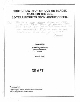
2023.2.2.10.2.5
·
Item
·
1994
Part of Dr. Paul Sanborn fonds
This document is a photocopy of a 1994 draft report prepared by Scagel, Hickling, and Evans for BC Ministry of Forests, Silviculture Branch. The document includes annotations by Lorne Bedford, BC MoF (ret.).
2023.2.2.4.4.126
·
Item
·
2004
Part of Dr. Paul Sanborn fonds
2023.2.2.4.4.137
·
Item
·
2004
Part of Dr. Paul Sanborn fonds
2023.2.2.4.4.138
·
Item
·
2004
Part of Dr. Paul Sanborn fonds
2023.2.2.4.4.139
·
Item
·
2004
Part of Dr. Paul Sanborn fonds
2023.2.2.4.4.127
·
Item
·
2004
Part of Dr. Paul Sanborn fonds
2023.2.2.4.4.128
·
Item
·
2004
Part of Dr. Paul Sanborn fonds
2023.2.2.4.4.129
·
Item
·
2004
Part of Dr. Paul Sanborn fonds
2023.2.2.4.4.130
·
Item
·
2004
Part of Dr. Paul Sanborn fonds
2023.2.2.4.4.131
·
Item
·
2004
Part of Dr. Paul Sanborn fonds
2023.2.2.4.4.132
·
Item
·
2004
Part of Dr. Paul Sanborn fonds
2023.2.2.4.4.133
·
Item
·
2004
Part of Dr. Paul Sanborn fonds
2023.2.2.4.4.134
·
Item
·
2004
Part of Dr. Paul Sanborn fonds
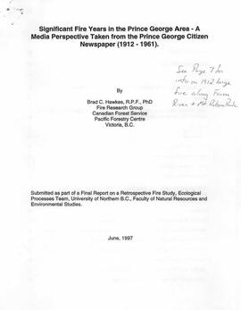
2023.2.1.07.1
·
Item
·
1997
Part of Dr. Paul Sanborn fonds
This paper by Brad Hawkes describes, from a newspaper media's perspective, changes in how fires were fought, reported, and described from 1912-1961 for significant fire years in the Prince George area.
Hawkes, Brad C.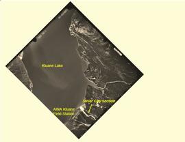
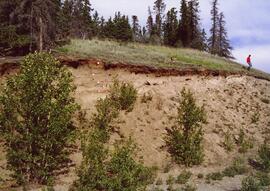
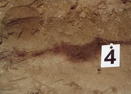
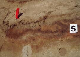
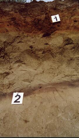
2023.2.2.8.03
·
Item
·
[2004?]
Part of Dr. Paul Sanborn fonds
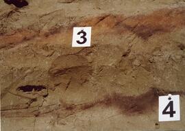
This PDF contains site location data and annotated soil profile photographs for soil charcoal samples at the Silver City section (site Y03-11).
2023.2.2.8.12.26
·
Item
·
2003
Part of Dr. Paul Sanborn fonds
2023.2.2.8.12.28
·
Item
·
2003
Part of Dr. Paul Sanborn fonds
2023.2.2.8.12.27
·
Item
·
2003
Part of Dr. Paul Sanborn fonds
2023.2.2.8.12.30
·
Item
·
2003
Part of Dr. Paul Sanborn fonds
2023.2.2.8.12.29
·
Item
·
2003
Part of Dr. Paul Sanborn fonds
2023.2.2.4.4.039
·
Item
·
2004
Part of Dr. Paul Sanborn fonds
2023.2.2.4.4.040
·
Item
·
2004
Part of Dr. Paul Sanborn fonds
2023.2.2.4.4.041
·
Item
·
2004
Part of Dr. Paul Sanborn fonds
2023.2.2.4.4.042
·
Item
·
2004
Part of Dr. Paul Sanborn fonds
2023.2.2.4.4.043
·
Item
·
2004
Part of Dr. Paul Sanborn fonds
2023.2.2.4.4.044
·
Item
·
2004
Part of Dr. Paul Sanborn fonds