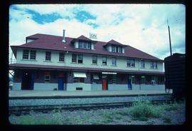
Mostrar 352 resultados

Archival description
352 resultados com objetos digitais Mostrar resultados com objetos digitais
Rail Road Tunnel
2012.13.1.29.13 · Item · 1991
Parte de J. Kent Sedgwick fonds

Image depicts a man and woman standing in the mouth of a tunnel from the old Kettle Valley Rail Road.

Rail Road Tunnel
2012.13.1.29.16 · Item · 1991
Parte de J. Kent Sedgwick fonds

Image depicts an unknown figure standing inside a tunnel from the old Kettle Valley Rail Road.

Rail Road Tunnel
2012.13.1.29.14 · Item · 1991
Parte de J. Kent Sedgwick fonds

Image depicts a woman standing inside a tunnel from the old Kettle Valley Rail Road.

Rail Road Tunnel
2012.13.1.29.15 · Item · 1991
Parte de J. Kent Sedgwick fonds

Image depicts a woman standing inside a tunnel from the old Kettle Valley Rail Road.

Railway - Near Summit
2012.13.1.100.19 · Item · 1999
Parte de J. Kent Sedgwick fonds

Image depicts two merging railway tracks, and what appears to be a frozen river, somewhere near the summit of a mountain.

Railway Bridge
2012.13.1.98.03 · Item · 1999
Parte de J. Kent Sedgwick fonds

Image depicts a railway bridge, possibly in the small town of Fraser, located on the Klondike Highway in B.C.

Railway Tracks and Old Houses
2012.13.1.87.009 · Item · [between 1975 and 1995]
Parte de J. Kent Sedgwick fonds

Image depicts railway tracks on the right side of the image, and several old houses alongside it. The location is uncertain.

Railway Tracks and Rocks
2012.13.1.91.39 · Item · 1979
Parte de J. Kent Sedgwick fonds

Image depicts a group of individuals who appear to be searching through the rocks near a railway track. It is possibly part of an educational trip.

River Ferry
2012.13.1.66.01 · Item · June 1987
Parte de J. Kent Sedgwick fonds

Image depicts a ferry on a river, possibly the Fraser River in the Lillooet area.

River Ferry
2012.13.1.66.02 · Item · June 1987
Parte de J. Kent Sedgwick fonds

Image depicts a ferry on a river, possibly the Fraser River in the Lillooet area.

Road and Junkyard
2012.13.1.82.22 · Item · 1980
Parte de J. Kent Sedgwick fonds

Image depicts a road with what appears to be a junkyard to the right of the image, likely located somewhere in Seton Portage, B.C.

Road to Skagway
2012.13.1.98.01 · Item · 1999
Parte de J. Kent Sedgwick fonds

Image depicts the road to Skagway, Alaska. Possibly located on the Klondike Highway in British Columbia with Tutshi Lake on the left.

Side of the Road
2012.13.1.78.64 · Item · 1982
Parte de J. Kent Sedgwick fonds

Image depicts a vehicled parked on the side of the road, with a view of the coast of Haida Gwaii in the background.

Sinclair Mills Railway Tracks
2012.13.1.87.014 · Item · [between 1975 and 1995]
Parte de J. Kent Sedgwick fonds

Image depicts railway tracks and buildings with a beehive burner on the left. The location is likely Sinclair Mills, B.C. Map coordinates 54°01'17.4"N 121°40'53.0"W

Skidder - Tree Trim Delimber
2012.13.1.122.27 · Item · May 1980
Parte de J. Kent Sedgwick fonds

Image depicts two unidentified individuals examining a tractor meant to delimb trees. It is located in Prince George, B.C.

Skiers and a Car
2012.13.1.129.14 · Item · 1975
Parte de J. Kent Sedgwick fonds

Image depicts a vehicle and a large group of skiers somewhere on Tabor Mountain in Prince George, B.C.

Snow Plow No.1
2012.13.1.100.03 · Item · 1999
Parte de J. Kent Sedgwick fonds

Image depicts the restored White Pass Snow Plow No.1 in Skagway, Alaska.

Snow-Covered Road
2012.13.1.87.100 · Item · [between 1980 and 2000]
Parte de J. Kent Sedgwick fonds

Image depicts a snow-covered road at an uncertain location.

Snowy Road
2012.13.1.87.039 · Item · [between 1975 and 1995]
Parte de J. Kent Sedgwick fonds

Image depicts a road covered in snow running through the woods at an uncertain location.

Snowy Road
2012.13.1.87.103 · Item · [between 1975 and 1995]
Parte de J. Kent Sedgwick fonds

Image depicts a snowy road at an uncertain location.

Snowy Road and Houses
2012.13.1.87.011 · Item · [between 1975 and 1995]
Parte de J. Kent Sedgwick fonds

Image depicts a snow-covered road with vehicle tracks, and several houses. The location is uncertain.

Spirit Fishing Boat
2012.13.1.77.12 · Item · Aug. 1979
Parte de J. Kent Sedgwick fonds

Image depicts a fishing boat on the water somewhere near Prince Rupert, B.C. Only half of its name is visible: "spirit."

Star Capella
2012.13.1.77.14 · Item · Aug. 1979
Parte de J. Kent Sedgwick fonds

Image depicts a large vessel docked in Prince Rupert, B.C. The name on its side is "Star Capella." The slide itself is labelled "superport."

Stewart Access Road
2012.13.1.51.036 · Item · May 1973
Parte de J. Kent Sedgwick fonds

Image depicts a man, possibly Kent Sedgwick, leaning against a sign forbidding public traffic on the Stewart Access Road from between 5 am to 8 pm. Located in Hazelton, B.C.

Stewart Access Road - Warning Sign
2012.13.1.51.037 · Item · May 1973
Parte de J. Kent Sedgwick fonds

Image depicts an unknown individual leaning against a sign at the Stewart Access Road which warns travellers to pack several days of food. Located in Hazelton, B.C.

Strathnaver - BCR
2012.13.1.50.023 · Item · 1975
Parte de J. Kent Sedgwick fonds

Image depicts the BCR, as well as the Dunkley Lumber Mill, in Strathnaver, B.C.