Mostrar 115 resultados

Archival description
112 resultados com objetos digitais Mostrar resultados com objetos digitais
Kitimat - Businesses
2012.13.1.67.08 · Item · 1979
Parte de J. Kent Sedgwick fonds

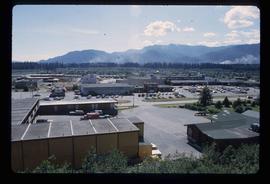
Image depicts numerous businesses, such as the Bay, Overwaitea, and Dairy Queen, somewhere in Kitimat, B.C.

Kitimat - Buildings
2012.13.1.67.09 · Item · 1979
Parte de J. Kent Sedgwick fonds

Image depicts several buildings in Kitimat, with the Bay being the tall one on the left.

Jack O' Clubs Hotel
2012.13.1.37.08 · Item · 1978
Parte de J. Kent Sedgwick fonds

Image depicts the Jack O' Clubs Hotel in Wells, B.C. It burned down on February 14th, 1994

Honey Sales
2012.13.1.91.57 · Item · 1979
Parte de J. Kent Sedgwick fonds

Image depicts several unidentified individuals standing in front of a store selling honey.

Forman's General Store
2012.13.1.37.33 · Item · [1980?]
Parte de J. Kent Sedgwick fonds

Image depicts the abandoned and crumbling Forman's General Store somewhere in or near either Barkerville or Wells, B.C.

Downtown Prince George Businesses and City Hall
2012.13.1.3.110 · Item · 12 Oct. 1989
Parte de J. Kent Sedgwick fonds

Image depicts George St in downtown Prince George with City Hall in the background. Also visible are the Prince George Hotel, Ming's Inn Chinese Restaurant, Fraser Stationers Ltd., Weiner King food cart, and a movie theatre. Map coordinates 53°54'55.0"N 122°44'36.1"W

Downtown Prince George Businesses
2012.13.1.3.107 · Item · 12 Oct. 1989
Parte de J. Kent Sedgwick fonds

Image depicts 4th Ave at Brunswick St. and the following businesses: Hart Drugs, The Yarn Barn, and Saveco. Map coordinates 53°54'59.9"N 122°44'52.9"W

Downtown Prince George Businesses
2012.13.1.3.108 · Item · 12 Oct. 1989
Parte de J. Kent Sedgwick fonds

Image depicts 4th Ave at Quebec St, showing the following businesses: The Yarn Barn, Golden Chalice Jewellers, Dandy Lines, Ultrasport, and Saveco. Map coordinates 53°54'58.6"N 122°44'47.5"W

Downtown P.G.
2012.13.1.5.28 · Item · Mar. 2003
Parte de J. Kent Sedgwick fonds

Image depicts an aerial view of downtown Prince George, B.C.

Chetwynd - Motor Hotel and Esso
2012.13.1.91.40 · Item · 1979
Parte de J. Kent Sedgwick fonds

Image depicts several businesses in a small section of Chetwynd, B.C. There is a motor hotel and a half-visible sign for an Esso gas station.

Central Street West
2012.13.1.3.115 · Item · 12 Oct. 1989
Parte de J. Kent Sedgwick fonds

Image depicts Central Street West, parallel to Highway 97 in Prince George, B.C. looking north. Shown: Prince George Motors and other car dealerships, Burger King, Grama's Inn, and the Spruceland Shopping Mall sign. Map coordinates 53°54'42.1"N 122°46'53.1"W

Central Business District
2012.13.1.3.057 · Item · July 1979
Parte de J. Kent Sedgwick fonds

Image depicts the Central Business District of Prince George looking north from Connaught Hill. Map coordinates 53°54'41.4"N 122°44'58.5"W

Businesses
2012.13.1.7.250 · Item · [2003?]
Parte de J. Kent Sedgwick fonds

Image depicts a street of businesses, possibly 3rd Avenue, in Prince George, B.C.

Buildings in Upper Fraser, BC
2012.13.1.87.067 · Item · [between 1975 and 1995]
Parte de J. Kent Sedgwick fonds

Image depicts a row of buildings in Upper Fraser, B.C. with the store (titled "Paradise") with a Pepsi sign. Map coordinates 54°07'09.1"N 121°56'47.0"W