File contents relate to: Mine Maintenance Issues. Document type(s) include: report. Notes: budget for projects.
File contents relate to: Mine Maintenance Issues. Document type(s) include: report. Notes: budget for projects.
File contents relate to: Mine Maintenance Issues. Document type(s) include: report. Notes: budget for projects.
Typed annotation on caption below photograph: "General Superintendent A.C. Beguin receiving 1965 Safety Award for Open Pits and Quarries in British Columbia from Mr. R.B. Bonar, Dept. of Mines and Petroleum Resources." Photograph depicts A.C. Beguin shaking hands with Mr. Bonar as he accepts a large plaque. Counter bar and curtains in background.
File contents relate to: Engineering, Asbestos. Document type(s) include: proposal, project. Notes: includes Flowsheet development, as built and report, proposal and drawings.
This map depicts a drawn bench plan for the estimated excavated waste for bench 6440 during the first quarter of 1972. Annotated details include the approximate excavated ore tonnages, broken and planned values for the first quarter and revised calculations from previous years values. Planned excavated areas are drawn with different colors.
This map depicts the pit layout and estimated waste extraction areas for 6410 bench. Extraction dates accompanied by its total tonnages are located within each planned area. Certain extraction dates are labeled with bench numbers. Annotated details include extraction dates, approximate total tonnages per area as well as extraction dates, total planned and broken tonnages, total tonnages from December 31, 1970 and numerical bench markers. The hand drawn plan consists of solid lines drawn with green, yellow, orange and lead pencils.
This map depicts the pit layout and estimated waste extraction areas for 6380 bench. Extraction dates accompanied by its total tonnages are located within each planned area. Certain extraction dates are labeled with bench numbers. Annotated details include extraction dates, approximate total tonnages per area as well as extraction dates, total planned and broken tonnages, total tonnages from December 31, 1970 from a survey done in September 1, numerical bench markers as well as a rough colored legend depicting extraction month by color. The hand drawn plan consists of solid lines drawn with green, yellow, red and lead pencils.
This map depicts the pit layout and estimated waste extraction areas for 6350 bench. Extraction dates accompanied by its total tonnages are located within each planned area. Annotated details include extraction dates, approximate total tonnages per area as well as extraction dates, total planned and broken tonnages and total tonnages from December 31, 1970 from a survey done in September 30. The hand drawn plan consists of solid lines drawn with red, green and orange colored pencils.
This map depicts the pit layout and estimated waste extraction areas for 6320 bench for the end of September to October. Extraction dates are included within certain portions of the plan. Annotated details include numerical bench markers, extraction dates, and approximate waste tonnage calculation for October. The hand drawn plan consists of solid and broken lines drawn with red, orange and lead pencils as well as black ink.
This map depicts the pit layout and estimated waste extraction areas for 6320 bench. Extraction dates accompanied by its total tonnages are located within each planned area. Certain extraction dates are labeled with bench numbers. Annotated details include extraction dates, approximate total tonnages per area accompanied by extraction dates, total planned tonnages, total tonnages from December 31, 1971 as well as a rough colored legend depicting extraction month by color. The hand drawn plan consists of solid lines drawn with green, red, orange and lead pencils.
This map depicts the generalized pit layout and estimated waste extraction areas for 6290 bench for the month of October and November. Extraction dates as well as total unbroken tonnages are included within certain portions of the plan. Annotated details include numerical bench markers, extraction dates, total tonnages to be extracted and approximate waste tonnage calculations for October. The hand drawn plan consists of solid and broken lines drawn with red, green, orange and lead pencils as well as black ink.
This map depicts the generalized pit layout and estimated waste extraction areas for 6290 bench for the month of November. Annotated details include numerical bench markers and waste extraction dates. The hand drawn plan consists of solid and dotted lines drawn with green, orange, red, blue and lead pencil.
This map depicts the pit layout and estimated waste extraction areas for 5870 bench for the end of August to November. Extraction dates, approximate extraction tonnages and ore, waste and talus locations are included throughout the plan. Annotated details include numerical bench markers, extraction dates, approximate extraction tonnages, ore, waste and talus locations as well as waste, ore, talus and total tonnage calculations for October. The hand drawn plan consists of solid and broken lines drawn with red, blue, orange and lead pencils as well as black ink.
This map depicts the pit layout and estimated waste extraction areas for 5840 bench for the end of September to November. Extraction dates, approximate extraction tonnages and ore, waste and talus locations are included throughout the plan. Annotated details include numerical bench markers, extraction dates, approximate total tonnages as well as waste and ore tonnage calculations for October. The hand drawn plan consists of solid and broken lines drawn with red, blue, orange and lead pencils as well as black ink.
This map depicts the generalized pit layout and estimated waste extraction areas for benches 5840 and 5870. Annotated details include numerical bench markers as well as extraction dates. The hand drawn plan consists of solid and dotted lines drawn with green and red pencil.
File contents relate to: Engineering. Document type(s) include: blueprint.
This map depicts the generalized pit layout and estimated waste extraction areas for 5810 bench. Annotated details include numerical bench markers, extraction dates and approximate ore extraction amounts. The hand drawn plan consists of solid and dotted lines drawn with green, orange and lead pencil.
File contents relate to: Engineering. Document type(s) include: summary, blueprint.
File contents relate to: Engineering. Document type(s) include: summary, blueprint.
File contents relate to: Engineering. Document type(s) include: summary, blueprint.
File contents relate to: Engineering. Document type(s) include: summary, blueprint.
File contents relate to: Engineering. Document type(s) include: summary, blueprint.
File contents relate to: Engineering. Document type(s) include: blueprint.
File contents relate to: Engineering. Document type(s) include: summary, blueprint.
File contents relate to: Engineering. Document type(s) include: summary, blueprint.
File contents relate to: Engineering. Document type(s) include: summary, blueprint.
File contents relate to: Engineering. Document type(s) include: summary, blueprint.
File contents relate to: Engineering. Document type(s) include: summary, blueprint.
File contents relate to: Engineering. Document type(s) include: summary, blueprint.
File contents relate to: Town Administration of Cassiar Townsite. Document type(s) include: meter records.
File contents relate to: Town Administration of Cassiar Townsite. Document type(s) include: meter records.
File contents relate to: Town Administration of Cassiar Townsite. Document type(s) include: meter records.
The topographic map shows mine and campsite holdings within the proposed mine site. Asbestos deposits, the tramline and water bodies, such as Troutline Creek, are also included.
Annotations include certain lot titles being crossed out as well as as indication of missing survey information.
File contents relate to: Engineering. Document type(s) include: blueprint.
File contents relate to: Engineering. Document type(s) include: blueprint. Notes: by Earls Industries.
File contents relate to: Engineering. Document type(s) include: blueprint. Notes: by Earls Industries.
File contents relate to: Cassiar Mine - operation and administration, Accounting / Payroll. Document type(s) include: correspondence.
This collection is proposed Cassiar development for the operating budget in 1979. The photographs are of poster-size presentation information. Topics covered include: operating graph of cost vs. fibre production, productivity rates, waste removal, ore mining cost vs. ton, primary crushing cost vs. ton, ore delivery cost vs. ton transported, stockpile drying and storage cost vs. ton feed, milling cost vs. ton fibre, establishment of funds allocated to townsite, staff, O&T and P&M, three proposed plans for 1979 and the requirements and costs for these proposals.
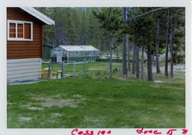
Photograph depicts part of a brown and white building similar to the "Director's Lodge" at Cassiar, B.C. (see items 2000.1.1.3.19.88 and 2000.1.1.3.19.89). Unidentified individuals visible inside greenhouse in fenced back yard. Forest in background. Handwritten annotation on verso of photograph: "Cassiar June 15 71".
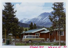
Photograph depicts brown and white building similar to the "Director's Lodge" at Cassiar, B.C. (see items 2000.1.1.3.19.88 and 2000.1.1.3.19.89). Station wagon parked in driveway behind short fence in foreground. Trees in foreground, forest and mountains visible in background. Handwritten annotation on verso of photograph: "Cassiar June 15 71".
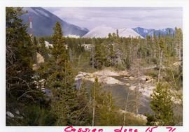
Photograph depicts flowing water believed to be Troutline Creek which ran south of Cassiar, B.C. Tailings pile and plant buildings visible behind forest in midground, northern mountain range in background. Handwritten annotation on verso of photograph: "Cassiar June 15 71".
Photograph depicts flowing water believed to be Troutline Creek which ran south of Cassiar, B.C. Tailings pile and plant buildings visible behind forest in midground, northern mountain range in background. Handwritten annotation on verso of photograph: "Cassiar June 15 71".
Photograph depicts flowing water speculated to be Troutline Creek which ran south of Cassiar, B.C. Forest on opposite shore and mountains in background. Handwritten annotation on verso of photograph: "Cassiar June 15 71".
Photograph depicts flowing water speculated to be Troutline Creek which ran south of Cassiar, B.C. Forest on opposite shore and mountains in background. Handwritten annotation on verso of photograph: "Cassiar June 15 71".
