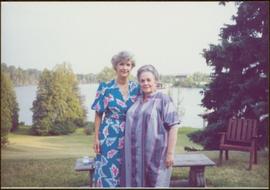
Geographic Features

Elements area

Taxonomy

Code

Scope note(s)

  • Includes both natural and artificial features
  • Physical landscape, built landscape
  • Urban and industrial landscapes
  • Topography
  • Site plans
  • Boundaries, districts, reserves, parks, sanctuaries, towns, etc.
  • NOTE: Mainly but not exclusively pertaining to photographic and cartographic records
  • SEE ALSO: Land, Settlement and Immigration

Source note(s)

  • MemoryBC Subject Groups

Display note(s)

    Hierarchical terms

    Geographic Features

      Equivalent terms

      Geographic Features

        Associated terms

        Geographic Features

          4134 Archival description results for Geographic Features

          4134 results directly related Exclude narrower terms
          Nechako Cutbanks Trail
          2012.13.1.3.091 · Item · 12 Oct. 1989
          Part of J. Kent Sedgwick fonds

          Image depicts the cutbanks on the other side of the Nechako, taken from the nature trail at Island Cache. Map coordinates 53°55'34.6"N 122°45'52.4"W

          Prince George
          2012.13.1.3.134 · Item · 12 Oct. 1989
          Part of J. Kent Sedgwick fonds

          Image depicts Prince George, possibly with the Northwood Pulpmill in the background.

          2012.13.6.51 · File · 1989
          Part of J. Kent Sedgwick fonds

          Item is an original 1989 map depicting Bella Coola in British Columbia, published by the Department of Energy Mines and Resources in Ottawa, Canada. The map also includes Kent Sedgwick's travels in the Bella Coola area highlighted in red.

          Survey of Prince George
          2012.13.2.02.29 · File · 1990
          Part of J. Kent Sedgwick fonds

          File consists of notes and reproductions relating to the survey of Prince George. Includes material on survey plans, lots in Prince George, original town planning, subdivision plans, and Kent Sedgwick's handwritten notes on surveying and town planning in Prince George. File primarily includes photopied maps depicting town lots and planning in Prince George. Includes: "RE: Title Search for Fairgrounds" typescript letter from Kent Sedgwick to Dr. Dick Rowe (26 Apr. 1990) and "Map showing South Fort George, Fort George (Central) and the additions surveyed in 1910 or later" reproduced map from the Fort George Tribune newspaper.

          2012.13.2.02.33 · File · [1990?]
          Part of J. Kent Sedgwick fonds

          File consists of maps and town surveys of early Prince George. Includes various reproduced 1915 maps and surveys depicting Prince George, Central Fort George, and Fort George: "Subdivision of part of Indian Reserve no. 1 lot 343 Cariboo District BC"; "Parcel Z map 1268"; "Plan of Subdivision lot 933"; "First addition to townsite of Central Fort George"; "Subdivision of lot 1511 Cariboo District BC"; "Townsite of Fort George" map originally made by R.H. Holland; "Plan of Subdivision of lot 1426 Fort George Collins Addition"; "Plan of subdivision of lot 932 Cariboo District"; and "Plan of subdivision of part of lot 2507."

          2009.6.1.511 · Item · 1990
          Part of The Honourable Iona Campagnolo fonds

          Trees in foreground, hills in background. Unidentified man stands on far left.

          Photograph is one of 11 images taken during a World Health Organization (WHO) trip, Human Rights of Women and Children, Peru, 1990. Possibly affiliated with World Council of Churches, International Ecumenical Delegation to Lima, Peru, 14-25 October 1990. See also items 2009.6.1.505 - 2009.6.1.515.

          2009.6.1.512 · Item · 1990
          Part of The Honourable Iona Campagnolo fonds

          Rock pile, unknown building, and hills can be seen in background.

          Photograph is one of 11 images taken during a World Health Organization (WHO) trip, Human Rights of Women and Children, Peru, 1990. Possibly affiliated with World Council of Churches, International Ecumenical Delegation to Lima, Peru, 14-25 October 1990. See also items 2009.6.1.505 - 2009.6.1.515.

          Cottonwood House
          2012.13.1.126.49 · Item · [1990?]
          Part of J. Kent Sedgwick fonds

          Image depicts the Cottonwood House Historic Site along Barkerville Highway, east of Quesnel, B.C. A sign posted by the fence reads: "For over half a century the Boyd family operated this haven for man and beast. Here weary travellers found lodging, food, and drink. Here fresh horses were hitched to stage-coaches and miners bought supplies. This historic road-house, built in 1864, stood as an oasis of civilization on the frontier of a rich new land."

          Forest
          2012.13.1.10.09 · Item · 22 Sept. 1991
          Part of J. Kent Sedgwick fonds

          Image depicts a few unknown individuals walking through the forest at Cheslatta.

          Rail Road Tunnel
          2012.13.1.29.13 · Item · 1991
          Part of J. Kent Sedgwick fonds

          Image depicts a man and woman standing in the mouth of a tunnel from the old Kettle Valley Rail Road.

          2012.13.4.05 · File · 1991-2000
          Part of J. Kent Sedgwick fonds

          File consists of notes, clippings, and reproductions relating to urban planning and writing by Kent Sedgwick. Includes: "The Downtown Streets of Prince George: a 'City Beautiful' Plan" typescript document by Kent Sedgwick (7 Oct. 1991); "A Report on the Issues of Downtown Revitalization in Prince George" from the Downtown Revitalization Committee (Nov. 1996); and "Letters to the editor" typescript letter to the Prince George Citizen from Kent Sedgwick (3 Mar. 1985).

          Moore's Meadow
          2012.13.2.14.04 · File · 1991-2000
          Part of J. Kent Sedgwick fonds

          File consists of clippings, notes, and reproductions relating to Moore's Meadow in Prince George. Includes: "Charles W. Moore" handwritten notes by Kent Sedgwick (2000); "The origin of Moore's Meadow" typescript by Kent Sedgwick; and "Moore's Meadow" typescript document by Mary Fallis (Jan. 1991).